
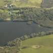
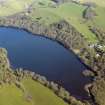
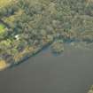
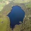
White Loch Of Myrton


Crannog (Period Unassigned)
Site Name White Loch Of Myrton
Classification Crannog (Period Unassigned)
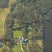
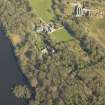
Alternative Name(s) Monreith House Policies
Canmore ID 62814
Site Number NX34SE 8
NGR NX 3585 4328
Datum OSGB36 - NGR
Permalink http://canmore.org.uk/site/62814


- Council Dumfries And Galloway
- Parish Mochrum
- Former Region Dumfries And Galloway
- Former District Wigtown
- Former County Wigtownshire
NX34SE 8 3585 4328
For Monreith House (NX 35577 42864) and associated buildings, see NX34SE 55.00.
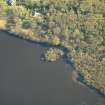
(NX 3585 4328) Lake Dwelling (NR) (Site of)
OS 6" map (1957)
Crannog, White Loch of Myrton: There is an artificial island towards the S end of the White Loch of Myrton. On examination the island was found to be surrounded by piles, and constructed of layers of furze, faggots, brushwood, fern, etc., like those at Dowalton (NX44NW 2, NX44NW 3, NX44NW 6 ).
R Munro 1885; RCAHMS 1912.
This crannog was inaccessable. No further information.
Visited by OS (IA) 31 January 1973
As the underwater component of Phase 2 of the South West Crannog Survey, the state of preservation of 14 crannog sites was evaluated in 12 lochs throughout Dumfries and Galloway as part of the Scottish Wetland Archaeology Programme (SWAP).
NX 3585 4328 White Loch of Myrton (NX34SE 8). Over 100 piles were noted in the loch bed surrounding this site, ranging up to 30m from the shore of the dry, tree-covered stone mound and in water up to c 3m deep. However, due to zero visibility the full extent of the site could not be accurately established. Two ash piles, 0.46m and 0.5m long, and displaying tool facets at the pointed ends, were present.
Sponsors: HS, Scottish Trust for Archaeological Research, AOC Archaeology Group, University of Nottingham
M G Cavers and J C Henderson 2002.
White Loch of Myrton (Bladnoch catchment): location cited as NX 3585 4328.
In 1895, Munro reported the existence of a crannog towards the S end of this loch. It was surrounded by piles, and comprised layers of furze, faggots, brushwood and fern.
The remains of this crannog were surveyed in July 2002 during the 2nd phase of the South-West Scotland Crannog Survey, with the intention of establishing an effective system of monitoring the rate of organic decay. Visibility underwater was nil, all observations being based on touch alone. The degree of prior erosion of the organic component of the crannog (down to the level of the lakebed and/or the crannog mound) has left the remainder well protected. Monitoring was not recommended.
The island itself was tree-covered, and not explored. The underlying crannog comprised a dense concentration of small vertical piles, over 100 of which were identified. These were apparently inserted into the loch bed in a halo around the stone mound; no piles were identified in the mound itself. They varied greatly in diameter (between 0.1 and 0.4m), and appeared to be spaced regularly (about 1m apart). Most of the tops of the piles lay flush with the lakebed, occasional standing about 0.2m proud.
Two examples bearing clear tool facets were sampled and identified as ash. These measure only 0.46m and 0.5m respectively, suggesting that the greater part of their height has been removed by decay. Bivalve tracks around their tops suggest that freshwater molluscs are the cause of their destruction.
The vegetation around the loch was found to be impenetrable. Dense alder carr lines the N shore, while the S, W and E shores are lined with a dense scrub woodland of willow, oak and some pine. This was very wet and boggy underfoot. The loch was fringed by phragmites reeds, which precluded the identification of the crannog.
J C Henderson, B A Crone and M G Cavers 2003.
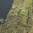
Excavation (4 April 2016 - 6 April 2016)
NX 3585 4328 (NX34SE 8) As part of the Celtic Crannogs Project, a small trial trench was excavated on the surface of White Loch of Myrton Crannog, 4–6 April 2016, to assess the character of surviving archaeological deposits and to provide context for a programme of lake sediment coring undertaken in the loch. The remains of a possible
ruinous wall were encountered in the upper deposits of the trench, beneath which was an ashy, charcoal-rich occupation deposit containing animal bone fragments. A surface of flat slabs, probably paving, was encountered at c1m below the surface of the crannog, approximately at the water table, which prevented further investigation. Environmental samples from the occupation deposit and organic-rich deposits below the paving produced a limited cereal assemblage including hulled barley (Hordeum Vulgare L), barley (Hordeum sp), emmer/spelt (T dicoccum/
Spelta sp) and a wheat (Triticum sp) caryopsis. Animal bone including a cattle molar and a small quantity of daub was recovered from the samples. Coring of the crannog mound identified six layers of non-oak timber interspersed with peaty soils beneath the paved surface identified in the
trench. Radiocarbon dating of wood samples from this core indicated that the lowest timbers were felled in the period 715–455 cal BC, while deposits from above the paving date to the period 393–206 cal BC. Core samples were also taken from lake deposits within the loch for multi-proxy
analysis as part of the Celtic Crannogs Project; this analysis is ongoing.
Archive: NRHE (intended)
Funder: University of Southampton, AHRC
Graeme Cavers, Anne Crone, Maarten van Hardenbroek and Tony Brown – AOC Archaeology Group
(Source: DES, Volume 17)
OASIS ID: aocarcha1-253344
Trial Trench (2 April 2016 - 3 April 2016)
A small trial trench was excavated on the surface of the crannog in White Loch of Myrton, Monreith, in order to assess the character of archaeological deposits relating to its occupation and to provide archaeological context for the analysis of lake sediment cores taken from the loch.
Information from OASIS ID: aocarcha1-253344 (G Cavers) 2016

