
Back Bay


Promontory Fort (Prehistoric), Settlement (Medieval)(Possible)
Site Name Back Bay
Classification Promontory Fort (Prehistoric), Settlement (Medieval)(Possible)
Canmore ID 62667
Site Number NX33NE 2
NGR NX 3696 3932
Datum OSGB36 - NGR
Permalink http://canmore.org.uk/site/62667


- Council Dumfries And Galloway
- Parish Glasserton
- Former Region Dumfries And Galloway
- Former District Wigtown
- Former County Wigtownshire
NX33NE 2 3696 3932.
(NX 3696 3932) Earthwork (NR)
OS 6" map (1957)
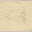
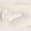
Promontory Fort, Back Bay: A small promontory has been defended by cutting a 28' wide ditch across its neck, 125' broad. On top of the scarp are the foundations, and a few facing stones of an 8' thick wall. A 9' wide causeway crosses the ditch, 23' from the S cliff edge. Behind the entrance, a hollow appears to mark the line of a passage between two walls for 48', c 7' wide for 40' of its length, and then narrowing. Near its end a large slab rises 1' above the turf, facing across it. N of the passage, immediately behind the rampart, there appears to have been a rectangular enclosure 28' x 26', but the surface indications are too vague to be certain, behind this, where the promontory falls away to the sea, there is a small plateau, 22' in diameter, which has apparently been levelled.
Possibly the 8' thick stone wall, and the foundations in the interior represent a secondary occupation of the site, perhaps medieval.
RCAHMS 1912, visited 1911; TS., visited 1955
Generally as described. The promontory measures 56.5m N-S by 23.0m E-W within the bank and ditch. The remains are sited on a seaward sloping promontory, the smallness of which suggests a homestead rather than a fort. The internal features are too slight to positively identify
Revised at 1/2500.
Visited by OS (DWR) 2 February 1973
Site recorded during a coastal erosion assessment of the N shore of the Solway Firth undertaken on behalf of Historic Scotland.Back Bay promontory fort (NMRS NX33NE 2) was studied in order to illustrate the range of coastal erosion processes affecting different sites.
A full report will be lodged with the NMRS.
Sponsor: Historic Scotland
M Cressey and R Toolis 1997
Field Visit (7 July 1911)
Promontory Fort, Back Bay.
On a grass-topped promontory of, small extent, jutting out from the face of the cliffs at the S. end of Back Bay, are the remains of a small stone-built fort. The neck of the promontory, some 125' in breadth, has been traversed by a ditch 28' wide, 8' in depth below the crest of the counterscarp, and 5' below that of the scarp. On the top of the latter there remain on both faces a row of large stones, evidently the foundations of a wall some 8' in thickness. At 23' from the edge of the cliff on the S. side a roadway about 9' wide passes over the ditch. on unexcavated ground into the interior. In rear of the entrance a hollow appears to mark the line of a passage between two walls for a distance of 48', seemingly about 7' wide for a distance of 40', and thereafter contracting. Near its termination a large slab protrudes about 1' above the turf, facing across it. To the right or N. of the passage immediately behind the rampart there appears to have been an enclosure measuring approximately 28' X 26', apparently rectilinear, but the indications on the surface are too vague to admit of a definite statement. In rear of this, where the level of the promontory falls away to seaward, there is a small plateau, which appears to have been levelled, measuring 22' in diameter.
O.S.M., WIGTOWN, xxxiv. NE.
Visited 7th July 1911.
Field Visit (1 September 1951)
This site was included within the RCAHMS Marginal Land Survey (1950-1962), an unpublished rescue project. Site descriptions, organised by county, are available to view online - see the searchable PDF in 'Digital Items'. These vary from short notes, to lengthy and full descriptions. Contemporary plane-table surveys and inked drawings, where available, can be viewed online in most cases - see 'Digital Images'. The original typecripts, notebooks and drawings can also be viewed in the RCAHMS search room.
Information from RCAHMS (GFG) 19 July 2013.
Field Visit (27 June 1955)
PROMONTORY FORT, BACK BAY, (Inventory No.6).
A plan of this fort was made at the date of visit. There is nothing of substance to add to the Inventory description, although it is possible that the 8 ft. thick stone wall, and the foundations of the interior, represent secondary occupation of the site - perhaps in medieval times.
369394 xxxiv NE.
27 June 1955.
Note (20 December 2013 - 23 May 2016)
This promontory work occupies a precipitous position on the cliffs along the SW coast of the Machars and is undercut by sea caves, the mouths of which have probably receded back into the top of the promontory since its construction. The defences, which cut off the approach from the N, comprise a stone wall some 2.4m thick where the faces survive, fronted with a ditch about 8.5m in breadth by up to 2.5m in depth externally. A causeway towards the E side of the promontory corresponds to an entrance 1.5m wide through the wall to provide access into the interior, which measures 56m from N to S by up to 23m transversely (0.1ha); the way the arc of defences meets the cliff-edge on the landward side a cleft above one of the sea caves suggests that the interior was once larger, but probably never more than about 0.13ha. The foundations of several structures can be seen in the immediate rear of the wall, and in 1955 RCAHMS speculated that these and the wall itself might be the result of a secondary occupation.
Information from An Atlas of Hillforts of Great Britain and Ireland – 23 May 2016. Atlas of Hillforts SC0215

