
Chapel Finian Well


Holy Well (Period Unassigned)
Site Name Chapel Finian Well
Classification Holy Well (Period Unassigned)
Canmore ID 62103
Site Number NX24NE 1
NGR NX 2783 4892
Datum OSGB36 - NGR
Permalink http://canmore.org.uk/site/62103


- Council Dumfries And Galloway
- Parish Mochrum
- Former Region Dumfries And Galloway
- Former District Wigtown
- Former County Wigtownshire
NX24NE 1 2783 4892.
(NX 2783 4891) Chapel Finian Well (NR)
OS 6" map (1957)
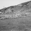
Chapel Finian Well lies within the drystone dyke enclosing Chapel Finian (NX24NE 2) and just inside the gate in the road wall. In 1882 it is described as "a circular, water-filled hollow, edged with stones". A stone on the N side bears a date, said to have been cut by a schoolmaster to give the supposed date of St Finian.
D Conway 1882; E W Mackie 1975
NX 2783 4892. A stone-lined well which is generally as described and measures 1.2m E-W by 1.0m and 1.0m deep. The datestone was not evident.
Surveyed at 1:2500.
Visited by OS (TRG) 27 April 1977

