
Following the launch of trove.scot in February 2025 we are now planning the retiral of some of our webservices. Canmore will be switched off on 24th June 2025. Information about the closure can be found on the HES website: Retiral of HES web services | Historic Environment Scotland
Little Carleton


Motte (Medieval)
Site Name Little Carleton
Classification Motte (Medieval)
Canmore ID 61979
Site Number NX18NW 3
NGR NX 13370 89522
Datum OSGB36 - NGR
Permalink http://canmore.org.uk/site/61979


- Council South Ayrshire
- Parish Colmonell
- Former Region Strathclyde
- Former District Kyle And Carrick
- Former County Ayrshire
NX18NW 3 1336 8952.
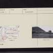
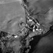
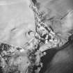
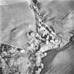
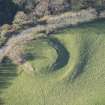
(NX 1336 8952) Carleton Mote (NR)
OS 6" map (1957)
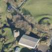
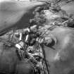
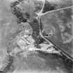
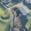
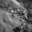
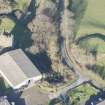
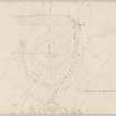
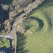
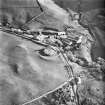
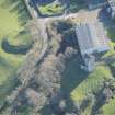
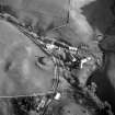
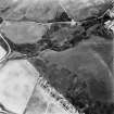
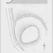
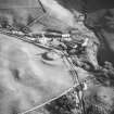
A motte - a nearly circular mound ranging in height from 6ft on the NE to 22ft on the SW, with a 20ft wide ditch round the base. Except on the north quadrant, the ditch has been completely obliterated by road making or cultivation, and the surviving portion, which is nowhere more than 1ft deep, is being rapidly ploughed away. Some slight indications of an upcast bank exist on the outer lip of the ditch on the NE side, but as it swings northwards the bank merges with the general slope of the hill and is lost. The top of the motte is level and void on plan measuring about 76ft in maximum length by 56ft broad. It is turf-covered, and shows no features of interest.
J Smith 1895; RCAHMS TS, 8 September 1955
A motte generally as described by the previous authorities. The top is divided by a slight scarp 0.3m high. The name 'Carleton Mote' is not used locally.
Resurveyed at 1:2500.
Visited by OS (JLD) 11 November 1955 and (RD) 10 December 1970
No change from previous field reports.
Visited by OS (JRL) 22 March 1977
Visible on a CUCAP aerial photograph.
(Undated) information in NMRS.
Field Visit (8 September 1955)
This site was included within the RCAHMS Marginal Land Survey (1950-1962), an unpublished rescue project. Site descriptions, organised by county, are available to view online - see the searchable PDF in 'Digital Items'. These vary from short notes, to lengthy and full descriptions. Contemporary plane-table surveys and inked drawings, where available, can be viewed online in most cases - see 'Digital Images'. The original typecripts, notebooks and drawings can also be viewed in the RCAHMS search room.
Information from RCAHMS (GFG) 19 July 2013.
Reference (1957)
This site is noted in the ‘List of monuments discovered during the survey of marginal land (1951-5)’ (RCAHMS 1957, xiv-xviii).
Information from RCAHMS (GFG), 24 October 2012.
Field Visit (June 1981)
Little Carleton NX 133 895 NX18NW 3
Situated 60m E of Carleton Castle there is a motte standing to a height of 5.5m on the WNW but only 2.3m on the ENE; its level summit measures 23.5m from ENE to WSW by 19m transversely. Around the base, on the N and E, there are the remains of a ditch 7m broad and up to 0.5m deep.
RCAHMS 1981, visited June 1981
(Smith 1895, 217-18; NMRS, AYD/24/1)

