 |
On-line Digital Images |
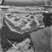
SC 1675787 |
RCAHMS Aerial Photography |
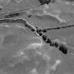
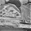
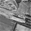
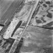
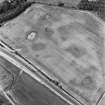
Drumflower, oblique aerial view, taken from the SE, showing the cropmarks of palisaded enclosures, a roman road and quarry pits, and a pit-defined structure and pit-alignment. |
29/6/1995 |
Item Level |
|
 |
On-line Digital Images |
SC 1754862 |
RCAHMS Aerial Photography |
Oblique aerial view |
1992 |
Item Level |
|
 |
On-line Digital Images |
SC 1754863 |
RCAHMS Aerial Photography |
Oblique aerial view |
1992 |
Item Level |
|
 |
On-line Digital Images |
SC 1754870 |
RCAHMS Aerial Photography |
Oblique aerial view. |
1992 |
Item Level |
|
 |
On-line Digital Images |
SC 1754871 |
RCAHMS Aerial Photography |
Oblique aerial view. |
1992 |
Item Level |
|
 |
On-line Digital Images |
SC 1754872 |
RCAHMS Aerial Photography |
Oblique aerial view. |
1992 |
Item Level |
|
 |
On-line Digital Images |
SC 1754873 |
RCAHMS Aerial Photography |
Oblique aerial view. |
1992 |
Item Level |
|
 |
On-line Digital Images |
SC 1754874 |
RCAHMS Aerial Photography |
Oblique aerial view. |
1992 |
Item Level |
|
 |
On-line Digital Images |
SC 1754875 |
RCAHMS Aerial Photography |
Oblique aerial view. |
1992 |
Item Level |
|
 |
On-line Digital Images |
SC 1754876 |
RCAHMS Aerial Photography |
Oblique aerial view. |
1992 |
Item Level |
|
 |
On-line Digital Images |
SC 1754877 |
RCAHMS Aerial Photography |
Oblique aerial view. |
1992 |
Item Level |
|
 |
On-line Digital Images |
SC 1754878 |
RCAHMS Aerial Photography |
Oblique aerial view. |
1992 |
Item Level |
|
 |
On-line Digital Images |
SC 1754879 |
RCAHMS Aerial Photography |
Oblique aerial view. |
1992 |
Item Level |
|
 |
On-line Digital Images |
SC 1754880 |
RCAHMS Aerial Photography |
Oblique aerial view. |
1992 |
Item Level |
|
 |
On-line Digital Images |
SC 1754881 |
RCAHMS Aerial Photography |
Oblique aerial view. |
1992 |
Item Level |
|
 |
On-line Digital Images |
SC 1754882 |
RCAHMS Aerial Photography |
Oblique aerial view. |
1992 |
Item Level |
|
 |
On-line Digital Images |
SC 1754883 |
RCAHMS Aerial Photography |
Oblique aerial view. |
1992 |
Item Level |
|
 |
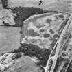
On-line Digital Images |
SC 1755013 |
RCAHMS Aerial Photography |
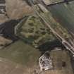
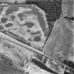
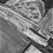
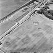
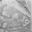
Drumflower, oblique aerial view, taken from the NE, showing the cropmarks of palisaded enclosures, a roman road and quarry pits, and a pit-defined structure and pit-alignment. |
29/6/1995 |
Item Level |
|
 |
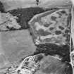
On-line Digital Images |
SC 1755014 |
RCAHMS Aerial Photography |
Drumflower, oblique aerial view, taken from the NE, showing the cropmarks of palisaded enclosures, a roman road and quarry pits, and a pit-defined structure and pit-alignment. |
29/6/1995 |
Item Level |
|
 |
On-line Digital Images |
SC 1755015 |
RCAHMS Aerial Photography |
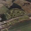
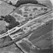
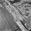
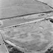
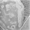
Drumflower, oblique aerial view, taken from the SW, showing the cropmarks of palisaded enclosures, a roman road and quarry pits, and a pit-defined structure and pit-alignment. |
29/6/1995 |
Item Level |
|
 |
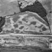
On-line Digital Images |
SC 1755016 |
RCAHMS Aerial Photography |
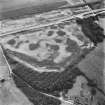
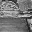
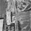
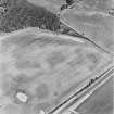
Drumflower, oblique aerial view, taken from the SE, showing the cropmarks of palisaded enclosures, a roman road and quarry pits, and a pit-defined structure and pit-alignment. |
29/6/1995 |
Item Level |
|
 |
On-line Digital Images |
SC 1755094 |
RCAHMS Aerial Photography |
Oblique aerial view. |
1978 |
Item Level |
|
 |
On-line Digital Images |
SC 1755095 |
RCAHMS Aerial Photography |
Oblique aerial view. |
1978 |
Item Level |
|
 |
On-line Digital Images |
SC 2460260 |
Records of the Ordnance Survey, Southampton, Hampshire, England |
Drumflower, NX15NW 26, Ordnance Survey index card, Recto |
1958 |
Item Level |
|


