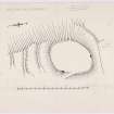
|
Prints and Drawings |
WGD 8/1 |
Records of the Royal Commission on the Ancient and Historical Monuments of Scotland (RCAHMS), Edinbu |
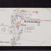
RCAHMS Marginal Land Survey inked drawing, |
c. 1955 |
Item Level |
|
|
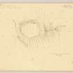
Prints and Drawings |
WGD 8/2 |
Records of the Royal Commission on the Ancient and Historical Monuments of Scotland (RCAHMS), Edinbu |
RCAHMS Marginal Land Survey pencil plane table survey drawing, |
25/6/1955 |
Item Level |
|
|
Manuscripts |
MS 28/457/29 |
Records of the Society of Antiquaries of Scotland, Edinburgh, Scotland |
Dunora fort.
|
1871 |
Item Level |
|
|
Manuscripts |
MS 36/173 |
Records of the Royal Commission on the Ancient and Historical Monuments of Scotland (RCAHMS), Edinbu |
Field notebook of K A Steer (RCAHMS). 'S6 - Kirkcudbright, Wigtown'. |
17/5/1951 |
Item Level |
|
 |
On-line Digital Images |
DP 151603 |
Records of the Royal Commission on the Ancient and Historical Monuments of Scotland (RCAHMS), Edinbu |
RCAHMS Marginal Land Survey inked drawing, |
c. 1955 |
Item Level |
|
 |
On-line Digital Images |
DP 151604 |
Records of the Royal Commission on the Ancient and Historical Monuments of Scotland (RCAHMS), Edinbu |
RCAHMS Marginal Land Survey pencil plane table survey drawing, |
25/6/1955 |
Item Level |
|
 |
Digital Files (Non-image) |
WP 000786 |
Records of the Royal Commission on the Ancient and Historical Monuments of Scotland (RCAHMS), Edinbu |
Scanned copy of RCAHMS Marginal Land Survey unpublished typescripts (Wigtonshire). |
1951 |
Item Level |
|
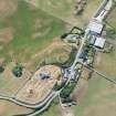 |
On-line Digital Images |
DP 281564 |
Historic Environment Scotland |
Oblique aerial view. |
16/7/2018 |
Item Level |
|
 |
On-line Digital Images |
SC 2459620 |
Records of the Ordnance Survey, Southampton, Hampshire, England |
Core Hill, Kirkmaiden, NX13NW 6, Ordnance Survey index card, page number 1, Recto |
1958 |
Item Level |
|
 |
On-line Digital Images |
SC 2459621 |
Records of the Ordnance Survey, Southampton, Hampshire, England |
Core Hill, Kirkmaiden, NX13NW 6, Ordnance Survey index card, page number 2, Verso |
1958 |
Item Level |
|
 |
On-line Digital Images |
SC 2459622 |
Records of the Ordnance Survey, Southampton, Hampshire, England |
Core Hill, Kirkmaiden, NX13NW 6, Ordnance Survey index card, Recto |
1958 |
Item Level |
|
 |
On-line Digital Images |
SC 2459623 |
Records of the Ordnance Survey, Southampton, Hampshire, England |
Core Hill, Kirkmaiden, NX13NW 6, Ordnance Survey index card, Recto |
1958 |
Item Level |
|
 |
On-line Digital Images |
SC 2459624 |
Records of the Ordnance Survey, Southampton, Hampshire, England |
Core Hill, Kirkmaiden, NX13NW 6, Ordnance Survey index card, Recto |
1958 |
Item Level |
|
 |
On-line Digital Images |
SC 2459625 |
Records of the Ordnance Survey, Southampton, Hampshire, England |
Core Hill, Kirkmaiden, NX13NW 6, Ordnance Survey index card, Recto |
1958 |
Item Level |
|
|
All Other |
551 166/1/1 |
Records of the Ordnance Survey, Southampton, Hampshire, England |
Archaeological site card index ('495' cards) |
1947 |
Sub-Group Level |
|


