
Cairn Pat


Fort (Prehistoric)
Site Name Cairn Pat
Classification Fort (Prehistoric)
Alternative Name(s) Cairn Piot
Canmore ID 60559
Site Number NX05NW 1
NGR NX 04421 56325
NGR Description Centre
Datum OSGB36 - NGR
Permalink http://canmore.org.uk/site/60559


- Council Dumfries And Galloway
- Parish Portpatrick
- Former Region Dumfries And Galloway
- Former District Wigtown
- Former County Wigtownshire
NX05NW 1 0442 5632.
(NX 0442 5632) Camp (NR)
OS 6" map (1957)
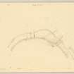
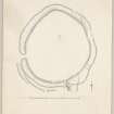
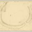
A fort or walled settlement crowning Cairn Pat, a dominant hill, and consisting of an enclosure 450' by 410' within two very ruinous walls, covered on the west by two now very faint ramparts with external ditches. A gap about 4' wide in the WNW arc of the second wall appears to be an entrance, and on the north a roadway some 7' broad passes diagonally through the defences from the NW.
From the SE a natural hollow runs out from the fort, flanked on the west by a face of outcropping rock and at the head of it, within the inner rampart on the west side, are the foundations of a small circular structure measuring internally some 7' and over all 12'.
R W Feachem 1963; 1965; RCAHMS 1912
The much mutilated remains of this fort are generally as described by Feachem, except that the additional ramparts on the west, which extend round to the southside, are now reduced to slight scarps and only very slightly traces remain of their external ditches. The most likely entrance to the fort is in the SE side.
Re-surveyed at 1/2500.
Visited by OS (WDJ) 22 February 1968
Field Visit (3 July 1911)
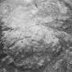
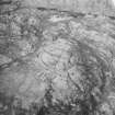
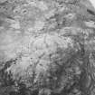
Cairn Pat is a prominent hill which rises to an elevation of 533' over sea-level, some 3m SW of Stranraer. Two ramparts of earth and stone, varying from 30ft to 40ft apart, encircle its summit, enclosing an area measuring approximately 450ft by 410ft. From the SE to W, where the slope of the hill is less steep, these defences are supplemented by a third mound, some 20ft outside, now low and inconspicuous, and at its E termination brought round to rest on the second mound. Its W. termination is less apparent. Facing WNW is a narrow break in the second mound about 4' across, which seems to be an entrance, and at the N a roadway some 7ft in breadth leads up into the interior, passing diagonally through the defences from the NW. From the SE a natural hollow runs out from the fort, flanked on the W by the face of an outcropping rock, and at the head of it, within the inner rampart on the W. side, are the foundations of a small circular structure, measuring interiorly some 7ft and overall 12ft. The ramparts of the fort are of earth and stone. The innermost has been the highest and has nowhere a height exceeding about 5ft on the side of the lower slope, and about 2ft above the interior. Both ramparts have been pillaged for stones to an excessive degree, in some places having been entirely removed, and that at no distant date.
RCAHMS 1911, visited 3 July 1911.
OS 6” map (1896) ‘Fort’
Field Visit (2 June 1955)
Fort, Cairn Pat (Inventory No. 413).
A plan of this fort was made at the date of visit. The defences comprise two parallel walls, both of which are now heavily ruined. The inner one has been about 10ft think, and the outer one 6-8ft thick. The solid stone cores of both walls are visible in a few places, but for the most part they are traceable by a rickle of stones or by a low stony mound. Traces of additional outer works can be seen on the west, namely a segmental rampart, with an outer ditch (now very faint), and a marginal mound and ditch. The rampart is not more than 12 ins. in height. The mound and ditches are practically levelled. There is an original entrance in the west side, where the two main walls return and unite on either side of the passage, but it is impossible to tell whether the gaps in the walls are primary or secondary.
Visited by RCAHMS (KA Steer) 2 June 1955.
Measured Survey (2 June 1955)
RCAHMS undertook a measured survey of the fort at Cairn Pat in 1955. The pencil drawings were combined and redrawn in ink but the plan was not published.
Field Visit (October 1984)
NX05NW 1 0442 5632.
This large fort encloses an area of about 1.2ha on Cairn Pat, a conspicuous hill which dominates the central portion of the Rhins peninsula. It measures 118m from E to W by 102m transversely within twin ramparts set between 5.5m and 9.5m apart; a third rampart provides additional protection on the gentle S approach to the fort, where there are also traces of a low bank immediately outside the defences.
Both of the two inner ramparts have been severely robbed, the first varying from a mound of rubble 4.8m thick by 0.8m high to a stony scarp up to 1.5m high externally, and the second from 3.1m thick and 0.5m high to 0.6m high externally. The third rampart, which springs from the second on SW and probably returns on the SSE (but the junction has now been obliterated) measures 2.1m thick by 0.3m high. The low bank outside the defences on the S continues along an irregular and intermittent course on the W side of the fort, where it is little more than a scatter of stones 1.5m wide, before finally dying out on the N. The position of the entrance is unclear and, although there are numerous gaps in the ramparts, only one on the SSE, where a modern track passes through the defences, penetrates to the interior; an entrance previously recorded on the WSW (RCAHMS Survey of Marginal Lands) appears to be the result of quarrying.
Apart from the remains of a bank reduced to little more than a low scarp and a scatter of stones, which is visible 14m within the inner rampart on the S, the interior of the fort is featureless.
RCAHMS 1985, visited (SH) October 1984.
(Name Book; R Feachem 1965; 1977; RCAHMS 1912)
Watching Brief (2001)
NX 044 564 An archaeological watching brief was undertaken during the excavation of foundations for a cabin and meter cabinet within Cairn Pat radio site. The summit of Cairn Pat is occupied by a Scheduled prehistoric hillfort (NMRS NX05NW 1). No features or deposits of archaeological significance were identified, and it was established that the majority of the fenced compound has been severely disturbed by earlier works.
Full report lodged with the NMRS.
Sponsor: Duncan Smith & Associates.
H Fulford 2001
Note (20 December 2013 - 31 August 2016)
This fort, which with the exception of the promontory enclosure on the Mull of Galloway is the largest of those on the Rhinns of Galloway, is situated on the summit of Cairn Pat, a hill with commanding views in every direction. Slightly oval on plan, it measures 132m from N to S by 118m transversely (1.15ha) within a pair of ramparts set between 5.5m and 9.5m apart. A third rampart springs from the outer on the SW and swings round the S flank of the fort to probably return on the SSE, but this junction has been destroyed; another low bank with an external ditch lies outside the third rampart on the SW and can be traced in intermittent scatters of stones around the W side, finally petering out on the N. All the ramparts have been extensively robbed and in places are difficult to follow on the ground, but the innermost seems to have been the thickest, ranging from a bank of rubble up to 4.8m thick by 0.8m high on the S to a stony scarp some 1.5m high on the N, whereas the outer of this pair is spread up to 3.1m thick by a maximum of 0.6m high externally; around the S quarter, however, it appears to be flanked internally by a shallow quarry ditch. The third rampart forms a bank only 2m thick by 0.3m high. As a result of the robbing it is also difficult to be certain of the position of any entrances, though there are traces of returns linking the concentric inner pair of ramparts on the WSW. Other gaps on the NE appear modern, while on the SSE a plan drawn up in 1955 shows the ramparts crossing the line of the access road up to the telecommunication masts on the summit; this follows a natural hollow that extends up into the interior between a high rock outcrop on the W and a lower natural scarp on the E, but there is no evidence to show that this was originally exploited as an entrance. The interior is featureless and much of the summit area is made up of exposed bedrock.
Information from An Atlas of Hillforts of Great Britain and Ireland – 31 August 2016. Atlas of Hillforts SC0186
Note (8 November 2021)
The location, classification and period of this site have been reviewed and changed from FORT (PERIOD UNASSIGNED).

