
Dunman


Fort (Iron Age)
Site Name Dunman
Classification Fort (Iron Age)
Canmore ID 60438
Site Number NX03SE 2
NGR NX 09761 33498
NGR Description Centre
Datum OSGB36 - NGR
Permalink http://canmore.org.uk/site/60438


- Council Dumfries And Galloway
- Parish Kirkmaiden
- Former Region Dumfries And Galloway
- Former District Wigtown
- Former County Wigtownshire
NX93SE 2 0978 3350
(NX 0978 3350) Camp (NR)
OS 6" map (1957)
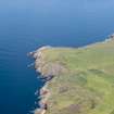
A fort crowning a flat-topped eminence, the SW flank of which falls precipitously to the shore. Similarly, the NW flank is unassailable, while the site is bordered by natural gullies to the NE and SE. The defences along the inner crests of these consist of a now ruinous massive wall originally 8' - 12' thick. No evidence of the date of this structure exists, but it most probably belongs to the Early Iron Age.
RCAHMS 1912; R W Feachem 1963.
The fort measures internally some 110m NW-SE by 100m. Walling is visible on the N, E and S sides and where best preserved in the E, consists of an inner wall face and heather-covered rubble some 3.0m wide. There are four approaches to the fort, but only one, in the NE, is faced as an entrance. The rocky interior is featureless.
Revised at 25".
Visited by OS (DWR) 7 February 1972
This fort is situated on Dunman and measures 100m from N to S by about 78m internally. Its wall has been reduced to a band of rubble up to 1m in height and spread to a maximum thickness of 3.5m, which follows the crest of a scarp over 7m high around the N, E and S sides of the summit; on the N and SSW the wall peters out, and there are no visible defences on the W, where the ground falls away steeply to the sea 150m below. There are entrances on the NNE and S, with a possible third on the N where a natural terrace provides access to the interior immediately beyond the end of the wall. A shallow hollow descends the scarp at the NNE entrance, which is blocked with three large boulders; at the S entrance a natural terrace drops obliquely down the scarp into what is probably an artificial hollow 2.5m broad with a bank up to 3m thick and 0.6m high (bracken-covered at the date of visit) on its outer lip. Although large quantities of stone were removed from 'a dry-stone wall' at the foot of the scarp on the E and S in 1848, there is no evidence that the bank on the S continues round to the E (Wilson Ms notes p.
449; NMRS, SAS 455); a gap in the wall on the ESE was probably made at this date. No structures are visible within the interior, although there are several grassy terraces amongst the rock outcrops.
Name Book 1848; W Todd 1854; G Wilson 1885; RCAHMS Survey of Marginal Lands; R W Feachem 1977; RCAHMS 1985, visited (SH) July 1984.
Field Visit (25 September 1953)
This site was included within the RCAHMS Marginal Land Survey (1950-1962), an unpublished rescue project. Site descriptions, organised by county, are available to view online - see the searchable PDF in 'Digital Items'. These vary from short notes, to lengthy and full descriptions. Contemporary plane-table surveys and inked drawings, where available, can be viewed online in most cases - see 'Digital Images'. The original typecripts, notebooks and drawings can also be viewed in the RCAHMS search room.
Information from RCAHMS (GFG) 19 July 2013.
Note (20 December 2013 - 31 August 2016)
This fort occupies the summit of Dunman, a flat rocky summit on the precipitous western coast of the Rhinns of Galloway. Its defences comprise a single wall, which follows the crest of a natural escarpment some 7m high around the eastern half of the summit from the N round to the SSW. Elsewhere the topography appear to have provided sufficient protection, on the SW falling away into the sea. The wall itself has been reduced to little more than a band of rubble spread 3.5m in maximum thickness and 1m in height, and in addition to a natural terrace that provides access to the interior on the N, there are original entrances on the NNE and S, while a gap on the ESE was probably made when large quantities of stone were removed in 1848 to build a march dyke. The rocky interior, which measures 100m from N to S by a maximum of 78m transversely, is featureless.
Information from An Atlas of Hillforts of Great Britain and Ireland – 31 August 2016. Atlas of Hillforts SC0177
Geophysical Survey (1 October 2020 - 31 July 2021)
NX 0052 7325 to NZ 9725 6795 The Rhins Revealed project forms part of the Rhins of Galloway Coastal Path initiative and aims to provide outreach related to the coastal archaeology of the Rhins area, as well as training for community volunteers and baseline surveys that can assist with future condition monitoring of sites along the coastal path route. As part of this project, several surveys were carried out between 2019 and 2021 including topographic surveys and drone photography and photogrammetry at Dunman (Canmore ID: 60438), Caspin (Canmore ID: 60923) and Kirklauchline (Canmore ID: 60642) forts; hut circles at Cairnmon Fell (Canmore ID: 60485) and at Castle Ban motte (Canmore ID: 65434). A resistivity survey was carried out over the upper surface of Castle Ban; the results suggest the presence of stone structures not visible at ground level.
NX 1417 3101, NX 1438 3074 A gradiometry survey was carried
out at the Mull of Galloway between the western (Canmore ID: 61050) and eastern (Canmore ID: 61051) earthworks, S of the road, using a Sensys MXPDA cart-mounted gradiometry system. The results suggest the presence of circular structures in the northern end of the dataset, and a possible enclosure positioned on a low knoll near the access to East Tarbet. The data is relatively noisy however, and the results have not been confirmed by excavation.
NX 06702 44683 At Doon Castle (Canmore ID: 60487), a promontory fort containing a broch-like stone roundhouse, topographic survey and 3D laser scanning were carried out in advance of conservation works planned for a later stage of the project.
NX 0324 6902 A high-resolution 3D model was produced of the Kilmorie Stone, Kirkcolm (Canmore ID: 60731) using photogrammetry, and the results presented online.
Archive: NRHE (intended)
Funder: Rhins of Galloway Coastal Path Project, Dumfries and Galloway Council, Heritage Lottery Fund, Coastal Communities Fund
Graeme Cavers, Jamie Humble and Marta Pilarska – AOC Archaeology Group
(Source: DES Vol 22)
Note (22 November 2021)
The location, classification and period of this site have been reviewed and changed from FORT (PERIOD UNASSIGNED).

