 |
On-line Digital Images |
SC 993206 |
RCAHMS Aerial Photography |
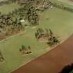
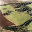
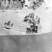
Scanned image of oblique aerial view centred on the deserted medieval village, bastle, church and burial ground, with remains of the rig, possible enclosures, country house and walled garden adjacent, taken from the SW. |
25/1/2001 |
Item Level |
|
 |
On-line Digital Images |
SC 1753292 |
RCAHMS Aerial Photography |
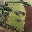
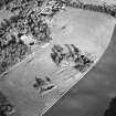
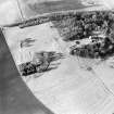
Oblique aerial view centred on the deserted medieval village, bastle, church and burial ground, with remains of the rig, possible enclosures, country house and walled garden adjacent, taken from the WSW. |
25/1/2001 |
Item Level |
|
 |
On-line Digital Images |
SC 1753293 |
RCAHMS Aerial Photography |
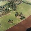
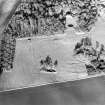
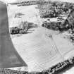
Oblique aerial view centred on the deserted medieval village, bastle, church and burial ground, with remains of the rig, possible enclosures, country house and walled garden adjacent, taken from the SW. |
25/1/2001 |
Item Level |
|
 |
On-line Digital Images |
SC 1753294 |
RCAHMS Aerial Photography |
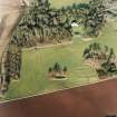
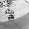
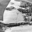
Oblique aerial view centred on the deserted medieval village, bastle, church and burial ground, with remains of the rig, possible enclosures, country house and walled garden adjacent, taken from the SSW. |
25/1/2001 |
Item Level |
|
 |
On-line Digital Images |
SC 1753297 |
RCAHMS Aerial Photography |
Oblique aerial view of the remains of the rig and possible enclosures with remains of the deserted medieval village, bastle, church, burial ground, country house and walled garden adjacent, taken from the SE. |
25/1/2001 |
Item Level |
|
 |
On-line Digital Images |
SC 1753319 |
RCAHMS Aerial Photography |
Oblique aerial view centred on the deserted medieval village, bastle, church and burial ground, with remains of the rig, possible enclosures, country house and walled garden adjacent, taken from the SW. |
25/1/2001 |
Item Level |
|
 |
On-line Digital Images |
SC 1753320 |
RCAHMS Aerial Photography |
Oblique aerial view of the remains of the deserted medieval village and bastle, church and burial ground, with remains of the rig, possible enclosures and country house adjacent, taken from the S. |
25/1/2001 |
Item Level |
|
 |
On-line Digital Images |
SC 1753321 |
RCAHMS Aerial Photography |
Oblique aerial view of the remains of the deserted medieval village and bastle, church and burial ground, with remains of the rig, possible enclosures and country house adjacent, taken from the S. |
25/1/2001 |
Item Level |
|
 |
On-line Digital Images |
SC 1753322 |
RCAHMS Aerial Photography |
Oblique aerial view of the remains of the deserted medieval village, bastle, church and burial ground, with the remains of the rig and possible enclosures adjacent, taken from the S. |
25/1/2001 |
Item Level |
|
 |
On-line Digital Images |
SC 1753324 |
RCAHMS Aerial Photography |
Oblique aerial view of the remains of the deserted medieval village and bastle, church and burial ground, with remains of the rig, possible enclosures and country house adjacent, taken from the ESE. |
25/1/2001 |
Item Level |
|
 |
On-line Digital Images |
SC 1753325 |
RCAHMS Aerial Photography |
Oblique aerial view of the remains of the rig and possible enclosures with remains of the deserted medieval village, bastle, church, burial ground and country house adjacent, taken from the E. |
25/1/2001 |
Item Level |
|
 |
On-line Digital Images |
SC 1753326 |
RCAHMS Aerial Photography |
Oblique aerial view of the remains of the rig and possible enclosures with remains of the deserted medieval village, bastle, church, burial ground, country house and walled garden adjacent, taken from the NE. |
25/1/2001 |
Item Level |
|
 |
On-line Digital Images |
SC 2457720 |
Records of the Ordnance Survey, Southampton, Hampshire, England |
Mordington, NT95NE 10, Ordnance Survey index card, page number 1, Recto |
1958 |
Item Level |
|


