
Marygoldhill Plantation


Settlement (Prehistoric)
Site Name Marygoldhill Plantation
Classification Settlement (Prehistoric)
Alternative Name(s) Marygold Plantation, Bunkle Edge
Canmore ID 59938
Site Number NT86SW 4
NGR NT 80467 60209
NGR Description Centre
Datum OSGB36 - NGR
Permalink http://canmore.org.uk/site/59938


- Council Scottish Borders, The
- Parish Bunkle And Preston
- Former Region Borders
- Former District Berwickshire
- Former County Berwickshire
NT86SW 4 8046 6020
(NT 8046 6020) Earthwork (NR)
OS 1:10,000 map, (1976).
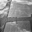
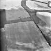
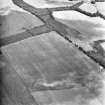
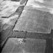
There is an earthwork, in fair condition, except on its E side where it has been mutilated by quarrying, in Marygoldhill Plantation, on ground sloping gently to the SE, at about 750ft OD. It is near rectangular on plan and consists, where best preserved, of two earthen ramparts with a medial ditch. There is an entrance in the SW corner. A number of courts and enclosures are evident within the enclosed area. Though described as a fort by the RCAHMS, this earthwork is almost certainly medieval.
Resurveyed at 1:2500.
Visited by OS (AC) 11 March 1966.
F Lynn 1897; D Christison 1895; RCAHMS 1915.
This earthwork is trapezoidal on plan and measures 80m by 67m within a bank and an external ditch; an outer bank on the SW and SE sides is of later date. The entrance is in the E corner. In the interior there are the remains of a smaller enclosure abutting the SW side, and on the NW side a natural terrace has been levelled to form a roughly rectangular platform.
RCAHMS 1980, visited 1979.
Scheduled [with NT86SW 3] as 'Marygold Plantation, forts 845m W and 730m NW of Marygold...'
Information from Historic Scotland, scheduling document dated 20 February 2009.
Field Visit (17 August 1908)
20. Fort, Marygold Hill Plantation.
About ¼ mile south-west along the plantation from the last, and about ½ mile west of Marygold steading, at an elevation of about 750 feet above the sea, is another fortified site (fig. 6 [DP 225496]). It is situated in a wood, and is rectangular in form, measuring interiorly in diameter some 243 feet and 219 feet. To the north-west and north-east there is a single rampart and ditch, while round the remainder of the enceinte the rampart is double. Towards the south there is an entrance which has a flanking defence on the north-west, extending for a considerable distance into the interior. On the south-west the distance from crest to crest of the double rampart is about 33 feet, while the inner mound is about 7 feet above the bottom of the ditch, and the outer 6 feet. The ramparts are of earth and stone.
RCAHMS 1915, visited 17 August 1908.
See Ber. Nat. Club, 1894-95, p. 367 (plan and secs.); Antiquaries, xxix. p. 167; Christison, p. 354.
OS Map: Ber., x. NE.
Field Visit (30 August 1950)
No details of this fort were visible on the date of visit as it was obscured by tree-felling operations.
Visited by RCAHMS (KAS) 30 August 1950.
Desk Based Assessment (November 2011 - October 2012)
Cultural Heritage assessment for the proposed Monashee Wind Farm identifies all historic environment features within the development area through desk-based assessment and field survey. The nature of effects on these features is discussed.
Funder: RDS Element Power
CFA Arachaeology Ltd.
Note (15 February 2016 - 21 October 2016)
This fort or fortified settlement is situated on the leading edge of Buncle Edge where the ground begins to fall away more steeply. Roughly trapezoidal on plan, it measures up to 80m from NE to SW by 67m transversely (0.5ha) within a rampart some 5.4m in thickness by 1m in height, and an external ditch 5.7m in breadth by 1.2m in depth. On the SE and SW, however, a later bank has been constructed along the outer lip of the ditch and crossing over at the E and W angles to complete the enclosure on the inner rampart; the date and purpose of this work is uncertain, though it may be no more than an early plantation enclosure. The original entrance was probably at the E angle, blocked by the addition of the later bank, while the gap in the SW side has probably been cut through both the enclosure bank and the rampart more recently still. The interior also appears to have been reused for a later farmstead comprising a terrace probably constructed for a rectangular building in the W angle of the interior, with a stone revetment along its leading edge facing into a large enclosure.
Information from An Atlas of Hillforts of Great Britain and Ireland – 21 October 2016. Atlas of Hillforts SC4105
Note (31 January 2020)
The location, classification and period of this site have been reviewed.
Sbc Note
Visibility: This is an upstanding earthwork or monument.
Information from Scottish Borders Council

