 |
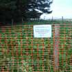
On-line Digital Images |
DP 316550 |
Records of CFA Archaeology Ltd, archaeologists, Musselburgh, East Lothian, Scotland |
Demarcation, Cairn 13, showing netlon fencing and signage in place, Phase 2 and 3, Penmanshiel Wind Farm, Scottish Borders, Scottish Borders |
8/10/2014 |
Item Level |
|
 |
On-line Digital Images |
DP 316551 |
Records of CFA Archaeology Ltd, archaeologists, Musselburgh, East Lothian, Scotland |
Demarcation, Cairn 13, showing netlon fencing and signage in place, Phase 2 and 3, Penmanshiel Wind Farm, Scottish Borders, Scottish Borders |
8/10/2014 |
Item Level |
|
 |
On-line Digital Images |
DP 316558 |
Records of CFA Archaeology Ltd, archaeologists, Musselburgh, East Lothian, Scotland |
Demarcation, Cairn 13, showing netlon fencing and signage in place, Phase 2 and 3, Penmanshiel Wind Farm, Scottish Borders, Scottish Borders |
8/10/2014 |
Item Level |
|
 |
On-line Digital Images |
DP 316559 |
Records of CFA Archaeology Ltd, archaeologists, Musselburgh, East Lothian, Scotland |
Demarcation, Cairn 13, showing netlon fencing and signage in place, Phase 2 and 3, Penmanshiel Wind Farm, Scottish Borders, Scottish Borders |
8/10/2014 |
Item Level |
|
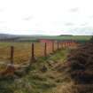 |
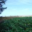
On-line Digital Images |
DP 316562 |
Records of CFA Archaeology Ltd, archaeologists, Musselburgh, East Lothian, Scotland |
Demarcation, Site 31, showing netlon fencing and signage in place, Phase 2 and 3, Penmanshiel Wind Farm, Scottish Borders, Scottish Borders |
8/10/2014 |
Item Level |
|
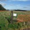 |
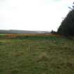
On-line Digital Images |
DP 316567 |
Records of CFA Archaeology Ltd, archaeologists, Musselburgh, East Lothian, Scotland |
Demarcation, Site 31, showing netlon fencing and signage in place, Phase 2 and 3, Penmanshiel Wind Farm, Scottish Borders, Scottish Borders |
8/10/2014 |
Item Level |
|
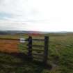 |
On-line Digital Images |
DP 316573 |
Records of CFA Archaeology Ltd, archaeologists, Musselburgh, East Lothian, Scotland |
Demarcation, Site 31, showing netlon fencing and signage in place, Phase 2 and 3, Penmanshiel Wind Farm, Scottish Borders, Scottish Borders |
8/10/2014 |
Item Level |
|
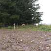 |
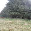
On-line Digital Images |
DP 316574 |
Records of CFA Archaeology Ltd, archaeologists, Musselburgh, East Lothian, Scotland |
Demarcation, Cairn 13, showing alternate fencing and signage, Phase 2 and 3, Penmanshiel Wind Farm, Scottish Borders, Scottish Borders |
28/10/2014 |
Item Level |
|
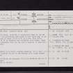 |
On-line Digital Images |
SC 2457379 |
Records of the Ordnance Survey, Southampton, Hampshire, England |
Penmanshiel, Andrew's Cairn, NT86NW 20, Ordnance Survey index card, page number 1, Recto |
1958 |
Item Level |
|
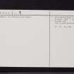 |
On-line Digital Images |
SC 2457380 |
Records of the Ordnance Survey, Southampton, Hampshire, England |
Penmanshiel, Andrew's Cairn, NT86NW 20, Ordnance Survey index card, page number 2, Verso |
1958 |
Item Level |
|


