
Lennel, Old Parish Church


Church (Medieval)
Site Name Lennel, Old Parish Church
Classification Church (Medieval)
Canmore ID 59582
Site Number NT84SE 17
NGR NT 85740 41173
Datum OSGB36 - NGR
Permalink http://canmore.org.uk/site/59582


- Council Scottish Borders, The
- Parish Coldstream
- Former Region Borders
- Former District Berwickshire
- Former County Berwickshire
NT84SE 17.00 85740 41173
NT84SE 17.01 85715 41159 Graveyard
(NT 8573 4117) Lennel Church (NR) (Remains of).
OS 6" map, (19579.
See also NT84SE 21.
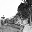
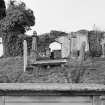
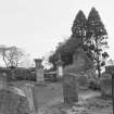
Lennel Old Parish Church, of 12th century date, was ruinous by 1705 and was replaced by a church in Coldstream which became the parish church in 1718. When seen by the RCAHMS, the W gable was almost entire, the side walls stood a few feet high, and in the S wall of the nave was a doorway with a segmental arch. The E gable had disappeared, and the full length of the building could not be accurately measured, though the nave was about 54ft and the existing gable was 26ft wide.
J Ferguson 1892; J Robson 1896; RCAHMS 1915, visited 1908; Fasti Eccles Scot, H Scott et al ed. 1917; I B Cowan 1967; RCAHMS 1980, visited 1979
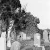
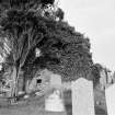
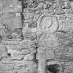
Only the W wall of this church, containing rectilinear windows, remains to any great entent. The church has been encroached upon for burials and gravestones have been inserted in all the walls. It is in poor condition.
Visited by OS(JD) 19 January 1955.
As described by the previous authorities.
Visited by OS (RD) 20 July 1966.
Field Visit (22 October 1908)
101. Lennel Church.
The remains of this church are situated on the north bank of the Tweed, rather more than a mile to the northeast of Coldstream. The west gable is almost entire. The side walls exist to a height of a few feet, and in the south wall of the nave there is a doorway with a segmental arch. The east gable has disappeared. The extreme length of the building is not accurately ascertainable, but that of the nave has been about 54 feet, and the width of the existing west gable is 26 feet.
See Ber. Nat. Club, 1890-91, p. 118.
OS Map: Ber., xxix. NW.
RCAHMS 1915, visited 22nd October 1908.
Photographic Survey (October 1961)
Photographic survey of Lennel Old Parish Church and graveyard, Berwickshire, by the Scottish National Buildings Record in 1961.
Watching Brief (4 March 2011 - 5 April 2011)
NT 85740 41173 A watching brief was undertaken, 4 March–5 April 2011, during emergency stabilisation works to the bank of the River Tweed at Lennel Churchyard. The work recorded five articulated human skeletons, all buried in an extended supine position with the head towards the W, consistent with traditional medieval and post-medieval Christian burial practice. The work also recorded numerous disarticulated bones and associated grave furniture. The most significant find was a well worn Scottish copper farthing, which was found on the forehead of a disarticulated skull. The coin was identified as a copper farthing of James III, issued c1466–1470, an example of the later 15th-century Scottish copper ‘Black Money’ but unfortunately corrosion had left so few visible details that it was not possible to ascribe it to a particular issue (identification by Dr D Bateson of Hunterian Museum). Staining on the skull suggested that the coin had been originally placed during burial and may indicate that the tradition of paying for the afterlife passage of souls was practised in the Scottish Borders at this time. The coin also appears to confirm that the churchyard was used for burial in the late 15th or early 16th century.
Archive: RCAHMS (intended)
Funder: Scottish Borders Council
GUARD Archaeology Ltd, 2011
Information also reported in Oasis (guardarc1-105395) 17 June 2013
Sbc Note
Visibility: Upstanding building, which may not be intact.
Information from Scottish Borders Council

