|
Prints and Drawings |
RXD 168/1 |
Records of the Royal Commission on the Ancient and Historical Monuments of Scotland (RCAHMS), Edinbu |
Plan, ink, 1":40' RCAHMS 47 Inv. 783 |
1947 |
Item Level |
|
|
Prints and Drawings |
RXD 168/2 |
Records of the Royal Commission on the Ancient and Historical Monuments of Scotland (RCAHMS), Edinbu |
PTS, pencil RCAHMS |
1947 |
Item Level |
|
|
Photographs and Off-line Digital Images |
C 94378 S |
|
Horsely Stream/Cove farm, view from W of rig-and-furrow cultivation with indeterminate remains |
|
Item Level |
|
|
Photographs and Off-line Digital Images |
D 89225 S |
|
Horseley Stream/Cove farm, View from SW of rig-and-furrow cultivation and indeterminate remains. |
1998 |
Item Level |
|
|
Manuscripts |
MS 2598 |
Papers of Roger J Mercer, archaeologist, Edinburgh, Scotland |
Edinburgh University, Bowmont Valley Project 1984-88: gazetteer of sites. |
c. 1989 |
Item Level |
|
|
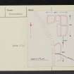
Prints and Drawings |
DC 16206 |
Papers of Roger J Mercer, archaeologist, Edinburgh, Scotland |
Survey drawing: Plan of a farmstead; sheepfolds; rig. |
1/4/1987 |
Item Level |
|
|
Prints and Drawings |
DC 16296 |
Papers of Roger J Mercer, archaeologist, Edinburgh, Scotland |
Survey drawing: Plan of a farmstead and sheepfold.. |
1987 |
Item Level |
|
|
Photographs and Off-line Digital Images |
H 85269 PO |
Papers of Roger J Mercer, archaeologist, Edinburgh, Scotland |
Oblique aerial photograph showing farmstead and cultivation remains. |
c. 1985 |
Item Level |
|
|
Photographs and Off-line Digital Images |
H 85270 PO |
Papers of Roger J Mercer, archaeologist, Edinburgh, Scotland |
Oblique aerial photograph showing farmstead and cultivation remains. |
c. 1985 |
Item Level |
|
|
Photographs and Off-line Digital Images |
H 85271 PO |
Papers of Roger J Mercer, archaeologist, Edinburgh, Scotland |
Oblique aerial photograph showing farmstead and cultivation remains. |
c. 1985 |
Item Level |
|
|
Photographs and Off-line Digital Images |
H 85272 PO |
Papers of Roger J Mercer, archaeologist, Edinburgh, Scotland |
Oblique aerial photograph showing cultivation remains. |
c. 1985 |
Item Level |
|
|
Photographs and Off-line Digital Images |
H 85273 PO |
Papers of Roger J Mercer, archaeologist, Edinburgh, Scotland |
Oblique aerial photograph showing settlement. |
c. 1985 |
Item Level |
|
|
Photographs and Off-line Digital Images |
H 85275 PO |
Papers of Roger J Mercer, archaeologist, Edinburgh, Scotland |
Oblique aerial photograph showing farmstead, sheepfolds and cultivation remains. |
c. 1985 |
Item Level |
|
|
Photographs and Off-line Digital Images |
H 85276 PO |
Papers of Roger J Mercer, archaeologist, Edinburgh, Scotland |
Oblique aerial photograph showing farmstead and cultivation remains. |
c. 1985 |
Item Level |
|
|
Photographs and Off-line Digital Images |
H 85285 PO |
Papers of Roger J Mercer, archaeologist, Edinburgh, Scotland |
Oblique aerial photograph showing farmstead, cultivation remains and boundary bank. |
c. 1985 |
Item Level |
|
 |
On-line Digital Images |
SC 2456657 |
Records of the Ordnance Survey, Southampton, Hampshire, England |
Horsely Stream, NT82SW 24, Ordnance Survey index card, Recto |
1958 |
Item Level |
|
 |
On-line Digital Images |
SC 2456658 |
Records of the Ordnance Survey, Southampton, Hampshire, England |
Horsely Stream, NT82SW 24, Ordnance Survey index card, page number 2, Verso |
1958 |
Item Level |
|
 |
On-line Digital Images |
SC 2456659 |
Records of the Ordnance Survey, Southampton, Hampshire, England |
Horsely Stream, NT82SW 24, Ordnance Survey index card, Recto |
1958 |
Item Level |
|
 |
On-line Digital Images |
SC 2456660 |
Records of the Ordnance Survey, Southampton, Hampshire, England |
Horsely Stream, NT82SW 24, Ordnance Survey index card, Recto |
1958 |
Item Level |
|
|
Manuscripts |
MS 2769/42 |
Papers of Roger J Mercer, archaeologist, Edinburgh, Scotland |
Survey Archive: Monument forms for 1987 season of field survey, Area 4, Monuments 1-36; three monument forms without monument numbers; maps and plans of area; AP traces. |
1987 |
Batch Level |
|
|
All Other |
551 166/1/1 |
Records of the Ordnance Survey, Southampton, Hampshire, England |
Archaeological site card index ('495' cards) |
1947 |
Sub-Group Level |
|


