
Craik Moor


Fort (Iron Age), Palisaded Settlement (Prehistoric), Ring Ditch House(S) (Prehistoric), Ring Groove House(S) (Prehistoric)
Site Name Craik Moor
Classification Fort (Iron Age), Palisaded Settlement (Prehistoric), Ring Ditch House(S) (Prehistoric), Ring Groove House(S) (Prehistoric)
Canmore ID 59085
Site Number NT81NW 6
NGR NT 8110 1907
Datum OSGB36 - NGR
Permalink http://canmore.org.uk/site/59085


- Council Scottish Borders, The
- Parish Morebattle
- Former Region Borders
- Former District Roxburgh
- Former County Roxburghshire
NT81NW 6 8110 1907
(NT 8110 1907) Fort (NR)
OS 6" map, (1962).
See also NT81NW 126.
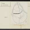
A palisaded settlement and a small stone-walled fort occupy the summit of a wedge-shaped spur, slightly raised above the main plateau of Craik Moor.
Two or possibly three lines of palisading can be distinguished, each line being drawn in a curve across the neck of the spur with the apex of the curve to the S.
The outermost line (IA on RCAHMS 1956 plan - see fig.438) consists of a pair of trenches not more than 18" wide and 6" deep, varying from 2'6" to 6' apart. They unite in a round end on the W side, and it is reasonable to assume that they represent the remains of a double wooden stockade similar to that at Hayhope Knowe (NT81NE 18). No definite end is visible on the E side, the trenches disappearing, due to soil-creep, where the natural slope steepens. Line IB, which is not concentric with IA, mostly consists of a single trench, similar to those of IA, but for a length of 115' the trench is interrupted by two slight banks with a gap between them. There can be little doubt that this trench has also held a wooden stockade, of the single type found at Hownam Rings (NT71NE 1), but the purpose of the banks is obscure: they are not sufficiently substantial to serve as a defence, yet are too large to be merely upcast from a palisade-trench. Line IC, which is roughly concentric with IB, comprises a single row of irregularly spaced earthfast boulders. For a length of 150' in the centre these boulders are embedded in the crest of a low bank up to 15' wide, but at either end they lie on level ground. The purpose of the bank is again not understood, but the boulders may represent either the packing-stones of a substantial palisade, having the uprights set in individual post-holes and not in a trench, or the grounders of a stone dyke similar to that outside the fort of Hownam Rings. Both IB and IC die out on the natural slopes on either side of the spur, leaving their precise limits undefined. No structures are visible in the space between IA and IB, but IC contains an oval hut measuring 27' by 22' within a shallow trench of the same size as the trenches of the huts on Hayhope Knowe. From the analogies quoted above for the various structural features, this phase clearly dates to the Early Iron Age.
An entirely new phase of occupation is represented by the small fort, defended by a single stone wall, at the extreme N end of the spur. On the S side the wall (II) is comparatively well preserved between a modern dyke and the W edge of the spur. It is from 8' to 12' thick and consists of a core of small stones, tightly packed together without earth, and faced on either side by stone blocks. No ditch is apparent. E of the dyke the line of the wall can be traced by debris running on a gentle curve for 70' to the edge of the spur, while its continuation round the margin of the summit area is indicated by tumbled core spread over the shoulder of the spur on the NW side and by a wasted fragment of core at the N apex. The absence of any trace of the wall on the NE side is no doubt due partly to stone-robbing for the modern dyke and partly to the steepness of the slope, which would carry off the material as the wall disintegrated. No entrance can now be seen, but the interior contains two hut circles each 27' in diameter within a ditch 5' wide, which are presumably contemporary with the fort. Huts outlined by similar ditches and dating to the Early Iron Age have been excavated at Braidwood, Midlothian.
RCAHMS 1956, visited 1949; A Ritchie 1970.
As described above.
Visited by OS (WDJ) 24 August 1960.
No change to previous field report.
Visited by OS (DWR) 23 July 1973.
This palisaded settlement and fort is as described in the previous information.
Revised at 1:10 000.
Visited by OS (TRG) 1 September 1976.
The summit of a prominent wedge-shaped spur, lying at the northernmost end of the Craik Moor plateau, is occupied by a succession of palisaded enclosures, an embanked enclosure and a stone-walled fort. The site commands extensive views over both the Calroust valley 1.3km to the E and the Hownam Burn 0.75km to the NW as well as The Street, the major cross-Border trackway (NT81NW 92), which traverses the saddle of Craik Moor between 0.3km and 0.8km to the S.
Moderate to moderately steep slopes from the W through to the N sides of the spur and steep to very steep slopes dropping away to the Stobhope Sike and Gloomy Cleuch on the NE side, provide more than adequate protection for any settlement on the spur. Not surprisingly then, the main sequence of defences lie on the S where the approach is over the gentle slope of the plateau. Commencing from the S, they comprise a single palisade-trench (A) concentric to a double palisade-trench (B) that appear to define an area below the summit knoll, three further single palisade-trenches (C, D and E), followed by a boulder- or rubble-built rampart (F) and a massive wall (G). The only defence recognised around the summit spur is a rubble-built rampart (H) though here the succession is more probably represented by an unseen vertical stratigraphy than the horizontal sequence displayed to the S.
Defensive sequence
Up to six principal components, comprising the eight separate defensive elements outlined above, may be defined from survey evidence.
Component 1 the twin elements of the single palisade-trench (A) and the double palisade-trench (B) are so closely aligned that they may form a single defensive conception enclosing a promontory, focussed to the S of the summit rather than on the knoll itself. The single palisade-trench (A) is 0.3m wide and about 0.15m deep and cuts across the whole promontory. The double palisade-trench (B), its ends conjoined at its W extent, the chord of which measures 98m across, lies from 6m to 7m within the outer line and comprises two slots, each 0.3m wide and averaging 0.15m deep, set approximately 1.3m apart. The terminal of the double palisade possibly marks the position of a gateway although the palisade does not resume to the N of any entrance. Instead, the well-worn hollow-way about 60m N of the double palisade terminus may be a more suitable candidate for an entrance at this stage.
This combination of a double-palisade-trench, forming a substantial c.10m wide barrier with a further single palisade outside, seems to form a single defensive unit. Stratigraphically there is no relationship between this element and any features in the interior or to any other defensive components. Later, however, the focus of settlement appears to move from the base of the summit to the knoll itself with a sequence of palisades and banks being constructed over the occupation area behind this substantial timber defence-work.
Component 2 The mutilated remains of a single palisade-trench (C) shadow the circuit of the double palisade-trench (B) for much of it's circuit often lying within 1m of its line. Towards the W side, from just beyond the modern fence line, the palisade-trench (C) cuts directly across the promontory before returning to the original line just behind the double palisade-trench. The line of this trench becomes faint but appears to extend further N than the return of palisade-trench (B) and is overlain by palisade-trench (E). The three house stances (1, 2 and 3) visible only from aerial photographs (D Harding, University of Edinburgh) may be associated with this component or with component 1.
Component 3 Fragmentary traces of a further single palisade-trench (D) may be observed within palisade-trench (C). Where most clearly defined, on the W side, the palisade-trench lies from 2m to 6m behind palisade (C). Following the circuit round to the E, the palisade gradually diverges from the course of palisade (C) before fading out at house (1) which it appears to overlie.
Component 4 A further single palisade-trench cuts across the whole of the promontory. The trench appears to cut across both the tenuous line of palisade-trench (C) and house (2).
Component 5 Set some 6m to 8m behind palisade-trench (E), there is a heavily robbed boulder-built bank (F) spread to 5m in width which appears concentric except towards the E end where it returns along the crest of the steep scarp falling away to the E. Rampart (H), punctuated by the hollow-way, may possibly form a continuation of the rampart thus forming an enceinte around the knoll, although it may represent a further phase of occupation in its own right. It is tempting to view the juxtaposition of the bank (F) with the palisade-trench (E) as a composite defence of the summit knoll associated with ring-ditch houses (5 and 6)
Component 6 Apparently the latest element on the site is a massive stone wall (G) stretching 78m across the promontory. It is partly built from stone gained from screes on the W side of the site but also from robbing of the rampart (F). Comprising a rubble-core of relatively small stones faced with sandstone blocks, the wall is of uneven thickness ranging from 5m to 2m at its base while at its narrowest point it is penetrated by a 2m wide gateway. The wall has been completely robbed out to the E of the march dyke, probably quarried for its construction. Survey of the site in 1985 saw this wall as no more than a promontory enclosure with no suggestion (pace RCAHMS 1956) that it ever extended (taking in rampart (H)) to form a more enclosive enceinte.
Settlement evidence
Within the complex sequence of palisades and ramparts, there are traces of at least nine house-sites. As described earlier house-stances (1, 2 and 3) are probably associated with palisades of either Components 1 or 2. Visible only from aerial photographs, these house-sites appear to average about 14m in diameter. A fourth possible house-stance (4) of smaller dimensions, lies within rampart F and is itself overlain by a ring-ditch house (5). This ring-ditch house measures 16m in diameter from N to S by 14m transversely overall and comprises a central platform measuring 10m from N to S by 8.6m transversely within a ditch averaging 2m in width (up to 4m on the N side). There is a slight trace of an external groove, but no evidence for an entrance. Two further ring-ditch houses (6 and 7) lie to the N of the massive stone wall (G). That to the W, measures 13m in diameter overall, and comprises a central platform measuring 8m in diameter within a 2m wide ditch. There is a 2.4m wide entrance in the NW angle connecting directly with the hollow-way (J). Immediately E is a third ring-ditch house (7) measuring 12m in diameter, and comprising a 7m diameter central platform within a ditch averaging 2m in width. There is a 1.8m wide entrance on the ENE. It must be doubtful if both these ring-ditch houses were contemporary as the eves would have overlapped. In addition to the houses described above there are a further five irregular platforms set within the circuit of ramparts (G) and (H) though they could relate to any of the main components. Four to the N and E of the hollow-way (J) have a NW aspect, and measure from 6m to 8m in diameter. The fifth, in the angle between the hollow-way and a low bank, measures 5m from N to S by 4m transversely.
Information from RJ Mercer (University of Edinburgh) 1 April 1985
RCAHMS, MS/2598, no. 32/430.
Note (15 September 2015 - 14 December 2016)
The fort on the summit of Craik Moor is not only one of the highest in Scotland, but also has the most complex arrangements of timber built perimeters of any fort yet recorded. Its defences comprise a wall that has probably succeeded a robbed rampart and a series of earlier and more extensive palisaded perimeters, though the precise sequence and the configuration of these timber defences is uncertain. While RCAHMS investigators who first recorded the defences in detail in 1949 believed that the inner wall formed a complete circuit, Roger Mercer in 1985 suggested that this, the latest period of fortification was effectively a promontory fort, with a stone-faced wall from 2.4m to 3.6m thick barring access to the summit from the S. If so, the interior is roughly triangular, measuring 63m in breadth immediately to the rear of the wall, and tapering northwards over a distance of at least 65m to the line of the earlier rampart (0.3ha), and possibly as much as 75m to the very tip of the summit area (0.37ha). In addition to several small scoops, it contains at least four large timber round-houses, two of which have clearly defined ring-ditches with well-formed entrances. Some of these round-houses, however, may belong to earlier phases and traces of another three are visible immediately outside the wall on the S, enclosed behind the next line of defence, a low bank with boulders protruding along its line. The RCAHMS investigators were puzzled by the character of this bank, suggesting that it perhaps supported a substantial palisade, accompanied by a roughly concentric palisade trench lying on the slope 8m outside its line. Mercer more reasonably suggests that this is the footing of a robbed rampart, and it is this rampart that once encircled the whole of the summit area, rather than the inner wall. Thus it forms a roughly oval enclosure measuring about 100m from N to S by 70m transversely (0.5ha), with an entrance on the E, adjacent to where the modern track was driven up onto the crest of the hill in 1987, slicing obliquely along the rampart. While this was possibly a composite defence of a rampart with an external palisade, on the E the palisade trench diverges from its line, possibly indicating that it was a separate enclosure, perhaps enclosing a slightly larger area of about 0.6ha. Apparently springing from a single hairpin terminal immediately outside this palisade on the W is a double palisade, with yet another palisade trench set concentrically some 10m outside it. This again gives the impression of a composite defence, with a timber rampart founded on the double palisade and a pale outside it. As this enclosure survives to us, it gives the impression of an attached annexe, adding a further 0.3ha, but this partly rests on the hairpin terminal, indicative of an entrance, and as Mercer suggests, if this is discounted, these palisades might equally well relate to a free-standing enclosure taking in the whole of the summit knoll and the lower slope to the S, enclosing an overall area of about 0.9ha. Within the 'annexe', Mercer noted traces of two more palisade trenches cutting across this side of the hill on slightly different lines, both almost certainly cut by the innermost of the palisades outside the robbed rampart, while aerial photographs show the footprints of at least four more timber round-houses; these, however, are very difficult to see on the ground on account of the traces of cultivation across this slope that are also revealed by the photographs and has been carried right up to the line of the inner wall.
Information from An Atlas of Hillforts of Great Britain and Ireland – 14 December 2016. Atlas of Hillforts SC3453
Sbc Note
Visibility: This is an upstanding earthwork or monument.
Information from Scottish Borders Council

