
Camp Tops


Linear Earthwork (Period Unassigned)
Site Name Camp Tops
Classification Linear Earthwork (Period Unassigned)
Canmore ID 59027
Site Number NT81NE 9
NGR NT 86269 17781
NGR Description From NT 86238 17797 to NT 86309 17789
Datum OSGB36 - NGR
Permalink http://canmore.org.uk/site/59027


- Council Scottish Borders, The
- Parish Morebattle
- Former Region Borders
- Former District Roxburgh
- Former County Roxburghshire
NT81NE 9 from 238 17797 to 86309 17789
(NT 86238 17797 to NT 86309 17789 Earthwork (NR)
OS 6"map, (1962).
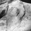
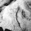
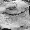
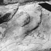
Across the lowest point of the col that extends from White Knowe to Camp Tops there runs a linear earthwork consisting of a mound with a ditch on its S side. The earthwork starts about 20 yds E of the old road which runs below the summit of the col on its W side, and from there bends to the SE and continues for 50 yds to a gap 9 yds wide, beyond which it runs E for 42 yds to end well down the steep slope above the Kingseat Burn. Two old tracks converge on the gap, one from either side of White Knowe.
RCAHMS 1956, visited 1938.
As described above.
Visited by OS(JLD) 24 August 1960.
No change.
Visited by OS(TRG) 9 August 1976.
A linear earthwork crosses a ridge, which stretches S to The Border and separates the valley of the Kelsocleuch Burn from that of the Kingseat Burn, at the lowest point of the saddle between Camp Tops and White Knowe. The earthwork can be traced for some 128m and comprises a bank averaging 3m in width and standing up to 1m in height over a ditch, which measures 1.6m across where best preserved, on the S side. The earthwork commences above a moderately steep slope and runs SE for 14m before being obliterated by the braided courses of a trackway and the old road extending up the W side of the ridge. After some 30m the earthwork resumes beyond the track and continues for a further 42m before being interrupted by another track whose course is tightly confined to an 8m break. The bank resumes to the E on a more easterly alignment, and continues for some 33m before terminating on a steep E-facing slope.
Information from RJ Mercer (University of Edinburgh) 15 March 1986
RCAHMS MS 2598. No. 46/600
Sbc Note
Visibility: This is an upstanding earthwork or monument.
Information from Scottish Borders Council

