
Cockburn East


Settlement (Prehistoric)
Site Name Cockburn East
Classification Settlement (Prehistoric)
Alternative Name(s) Edinshall
Canmore ID 58762
Site Number NT76SE 12
NGR NT 77328 60115
NGR Description Centre
Datum OSGB36 - NGR
Permalink http://canmore.org.uk/site/58762


- Council Scottish Borders, The
- Parish Duns
- Former Region Borders
- Former District Berwickshire
- Former County Berwickshire
NT76SE 12 7732 6011.
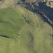
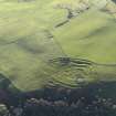
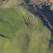
(NT 7732 6011) Settlement (NR)
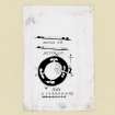
Enclosures, Edinshall (see RCAHMS 1915 plan, fig.66).
RCAHMS 1915, visited 1908.
This settlement is generally as planned by the RCAHMS.
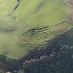
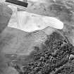
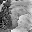
The large depression in the N is generally 1.2m in depth, and the main rectangular enclosure is defined by a bank 0.6m in height. The area is considerably mutilated and covered with stones.
Visited by OS(JD) 7 January 1955 and (RD) 27 April 1966.
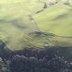
This unenclosed settlement comprises two stone-walled houses (measuring 4.9m and 5.7m in diameter respectively) and an enclosure (19.5m by 11m within a stony bank with an entrance on the E) which buts on to a circular scooped court 17.5m in diameter. The two houses straddle the line of the enclosure wall; the smaller is entered from the enclosure and the larger from outside.
RCAHMS 1980, visited 1979.
Photographed by the RCAHMS in 1980.
RCAHMS 1980 AP Catalogue.
The settlement is visible on vertical air photograph (OS 70/365/240, flown 1970).
Information from RCAHMS (JH) 12 May 1998.
Field Visit (8 August 1908)
120. Enclosures, Edinshall.
On a piece of waste ground in the upper angle of the field in which Edinshall is situated, about 300 feet south of the east entrance to the enclosure, east-north-east of Cockburn Law, and at an elevation of 720 feet above the sea, are a series of foundations (fig. 66 [DP 148105]) with their main axes lying north and south. At the north end is a large saucer-shaped depression with a diameter of 68 feet, its upper edge level with the field on the north and west, but enclosed by a stone bank on the south and eastabout 2 feet high and 12 feet broad at base. The entrance is towards the east. Adjoining it to the south is an enclosure, rectangular towards the north and south-east, but with its south-west angle occupied by about one-half of a circular foundation, the other half of which lies outside it to the west. It is surrounded by a low bank of stones, dilapidated on the west side, but fairly complete on the east, where there is an entrance. Its longest diameter from north to south is 68 feet, and its breadth 46 feet. The circle in the south-west corner has a diameter of 22 feet, and opens into the interior. Adjoining this circle, towards the south, are the remains of another of similar character, and a third adjoins the latter to the east. At 22 feet south-east of the entrance to the oblong enclosure are the remains of an outer stony mound running north and south, and apparently curving slightly towards the west. Cultivation on all sides has been carried close to the foundations.
RCAHMS 1915, visited 8th August 1908.
OS Map: Ber., x. NW. (unnoted).
Note (23 December 2019)
The location, classification and period of this site have been reviewed.
Sbc Note
Visibility: This is an upstanding earthwork or monument.
Information from Scottish Borders Council

