
Grudie


Corn Drying Kiln(S) (Post Medieval), Grain Mill (Post Medieval), Head Dyke (Post Medieval), Township (Post Medieval)
Site Name Grudie
Classification Corn Drying Kiln(S) (Post Medieval), Grain Mill (Post Medieval), Head Dyke (Post Medieval), Township (Post Medieval)
Canmore ID 5867
Site Number NC70NW 3
NGR NC 745 087
NGR Description centred on NC 745 087
Datum OSGB36 - NGR
Permalink http://canmore.org.uk/site/5867


- Council Highland
- Parish Rogart
- Former Region Highland
- Former District Sutherland
- Former County Sutherland
NC70NW 3 745 087.
(Centred: NC 745 087) Grudy
W Roy 1747-55
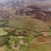
The deserted township of Grudie contains between forty and fifty ruined buildings from 0.3m to 1.8m high, and measuring from 5.8m by 3.1m to 32.3m by 3.0m. Associated with these are numerous dry-stone enclosures, some of which are attached to the ruined buildings, two corn-drying kilns and many old field walls and banks. To the S of the settlement, and on the flat plain N of the River Brora are extensive areas of lazy beds and field clearance.
According to Mr Murray (retired shepherd, 397 Druimanairgeidh, Rogart) Grudie was depopulated in 1822-3 on the orders of Lt-Col Sutherland.
The land was used for sheep farming, and by 1823 only one house remained occupied by the shepherd (a Mr MacKay).
Visited by OS (R B) 22 February 1966.
Grudie deserted township is generally as described. There are the remains of three corn-drying kilns and at NC 7428 0903, the ruins of a corn mill measuring 9.0m by 4.5m and surviving up to 1.4m high on the side where the wheel housing would have been. The lade survives in a broken state, but nothing remains of the mill machinery.
Kilns surveyed at 1:10,000.
Visited by OS (J M) 31 March 1981.
Note (16 November 1995)
A township comprising twenty-five unroofed buildings, numerous enclosures and a head-dyke is depicted on the 1st edition of the OS 6-inch map (Sutherland 1879, sheet xcvi). Eighteen unroofed buildings, some enclosures, some field walls and a head-dyke are shown on the current edition of the OS 1:10,000 map (1970).
Information from RCAHMS (SAH) 16 November 1995

