 |
On-line Digital Images |
SC 2073035 |
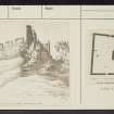
Historic Environment Scotland |
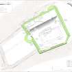
Plan of Hume Castle, showing phase 2 of development, 13th - 14th Centuries |
28/8/2019 |
Item Level |
|
 |
On-line Digital Images |
SC 2073036 |
Historic Environment Scotland |
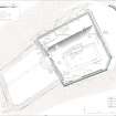
Plan of Hume Castle, showing phase 4 of development, late 18th Century |
28/8/2019 |
Item Level |
|
 |
On-line Digital Images |
SC 2075079 |
Historic Environment Scotland |
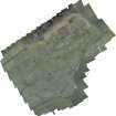
Ortho Aerial Photograph of Hume Castle and the surrounding landscape created from a UAV photography |
27/7/2017 |
Item Level |
|
 |
On-line Digital Images |
SC 2076864 |
Historic Environment Scotland |
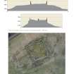
Hume Castle - Profile lines showing the visible wall remains and current ground height and plan showing the position of profile lines |
10/2018 |
Item Level |
|
 |
On-line Digital Images |
SC 2455102 |
Records of the Ordnance Survey, Southampton, Hampshire, England |
Hume Castle, NT74SW 3, Ordnance Survey index card, page number 1, Recto |
1958 |
Item Level |
|
 |
On-line Digital Images |
SC 2455103 |
Records of the Ordnance Survey, Southampton, Hampshire, England |
Hume Castle, NT74SW 3, Ordnance Survey index card, page number 2, Verso |
1958 |
Item Level |
|
 |
On-line Digital Images |
SC 2455104 |
Records of the Ordnance Survey, Southampton, Hampshire, England |
Hume Castle, NT74SW 3, Ordnance Survey index card, Recto |
1958 |
Item Level |
|
 |
On-line Digital Images |
SC 2455105 |
Records of the Ordnance Survey, Southampton, Hampshire, England |
Hume Castle, NT74SW 3, Ordnance Survey index card, Recto |
1958 |
Item Level |
|
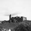 |
On-line Digital Images |
SC 2506149 |
|
General view. |
|
Item Level |
|


