
Cnoc Achadh Na H-uaighe


Archaeological Landscape (Prehistoric) - (Modern)
Site Name Cnoc Achadh Na H-uaighe
Classification Archaeological Landscape (Prehistoric) - (Modern)
Canmore ID 5856
Site Number NC70NW 2
NGR NC 716 075
Datum OSGB36 - NGR
Permalink http://canmore.org.uk/site/5856


- Council Highland
- Parish Rogart
- Former Region Highland
- Former District Sutherland
- Former County Sutherland
NC70NW 2 716 074.
(A: NC 7166 0752) Hut Circle (NR) (B: NC 7165 0740 and C: NC 7167 0737) Hut Circles (NR) (Name NC 7171 0732) Field System (NR)
OS 1:10,000 map, (1970)
Just beyond Achadh na h-Vaighe crofts is a very considerable group of mounds. Near the centre of the group, on the upper side of the two tracks that run to West Langwell, is a hut circle with an entrance from the south-east. It measures internally 39 by 42ft. with a bank about 6ft thick. Just above the upper track and a short distance to the west of the last-mentioned hut are the dilapidated foundations of a more complicated structure. It comprises three compartments; a main oval one measuring 17 by 29 1/2ft into which the entrance opens from the south; and two apsidal compartments opening off it, one at the north and another towards the south-west,each measuring internally 16 by 14ft. The principal entrance is 2ft 8ins wide, through a passage 8ft long.
RCAHMS 1911, visited 1911.
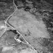
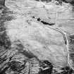
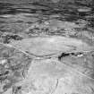
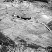
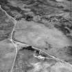
There are three hut circles (A-C) and an extensive field system.
Visited by OS (R B) 1 March 1966
On the W flank of Cnoc Achadh na h-Vaighe is a settlement of three hut circles (A-C) one (A) with a souterrain, and an accompanying well-preserved field system. The hut circle described by the RCAHMS is probably A, the most upstanding of the three huts, and the "complicated structure", is probably that at NC 7160 0755, described later.
Hut A, levelled into a slight change of slope and partially heather and turf-covered, measures 10.5m diameter within walling, 0.8m high and spread to 2.5m expanding to 3.5m in the sides of the entrance in the SE; the walling is distinguished by a fairly well-preserved inner face of large boulders, some up to 1.1m high. The hut interior contains an amount of turf-covered debris and also possible footings of a bothy-type structure 3.0 by 2.5m.
Extending radially from NW exterior of the hut and curving round to the W, is the collapsed line of a souterrain. It shows as a depression, 0.8 to 1.1m deep by 2.5 to 3.0m wide by some 12.0m long, with stone protruding in the turf-covered bottom particularly one lintel-type slab; opposing blocks in the sides of the depression near the hut end are 1.0m apart. The continuity of the depression is broken by two transverse ridges, possibly indicating lintel slabs remaining in situ.
'B' and 'C' are very similar but lack the rubust construction of hut 'A'. They are heather covered, and measure respectively 13.0 by 12.0m and 14.0 by 13.0m within obscure wall spreads; entrances are in the S, the line of the long axis in both cases. A mound abuts the NW interior of hut C.
The field system is denoted in numerous stoned clearance heaps, spaced from 5.0 to 20.0m apart, interspersed with lynchets and occasional banks. There are two distinct field plots evident, one 60.0 by 12.0m the other 20.0 by 10.0m.
The structure at NC 7160 0755 appears to comprise two contiguous enclosures; one, 9.5m across within a bank 2.0m wide and 0.2m high contains a swelling 5.0m in diameter, and the other is more elongated and incomplete. Though this bears little relationship to the RCAHMS description, it is severely reduced and mutilated with stone added, and there is no other feature of any description immediately west of hut A. There is another vague structure at NC 7160 0746 apparently comprising an oblong enclosure, 10.0 by 5.0m with two small enclosures adjoining. The purpose of this structure and that at NC 7160 0755 remains uncertain, but the depth of peat enveloping them suggests considerable antiquity, and they may be broadly contemporary with the hut circles and field system.
Revised at 1:10,000.
Visited by OS (J M) 6 April 1981.
Field Visit (9 March 1995)
NC70NW 2 716 074.
NC70NW 2.01 NC 7166 0751 Hut-circle; Souterrain; Hut (ROG95 42)
NC70NW 2.02 NC 7165 0740 Hut-circles (ROG95 43, 44) and NC 7767 0737
NC70NW 2.03 NC 7160 0754 Hut-circle (ROG95 41)
NC70NW 2.04 NC 7161 0751 Sheepfold (possible)
NC70NW 2.05 NC 716 074 Field-systems; Small cairns (ROG95 571)
On the W flank of Cnoc Achadh na h-Uaighe there are four hut-circles, one of which has an adjoining souterrain, set within a scatter of small cairns amongst which there may have been some small plots. Fragments of a much larger earth-banked pre-improvement field-system impinge on the W side of the earlier cultivation remains, parts of the which have been removed by more recent improvement for grazing.
Visited by RCAHMS (DCC) 9 March 1995

