
Greenlaw, General


Burgh (Medieval), Village (Period Unassigned)
Site Name Greenlaw, General
Classification Burgh (Medieval), Village (Period Unassigned)
Canmore ID 58513
Site Number NT74NW 33
NGR NT 71057 46001
Datum OSGB36 - NGR
Permalink http://canmore.org.uk/site/58513


- Council Scottish Borders, The
- Parish Greenlaw
- Former Region Borders
- Former District Berwickshire
- Former County Berwickshire
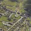
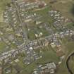
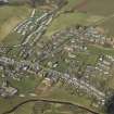
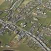
The town of Greenlaw is the second settlement of that name. Old Greenlaw was situated further south, near Old Greenlaw House. In the later part of the sixteenth century, the village of New Greenlaw began to expand, and soon became the larger of the two settlements. It was accorded burgh status in 1600.
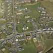
In 1698, Greenlaw became county town of Berwickshire, replacing Berwick, which had been in English hands since the late fifteenth century. Its new status heralded a programme of building work, the results of which can still be seen today, and which include the County Hall and the old jail. Some of the construction work was carried out at the expense of the Earls of Marchmont, who had been instrumental in erecting Greenlaw to the county status. Greenlaw finally lost its county town status to Duns in 1903.
Greenlaw is arranged around two streets and a square. The two streets, Duns Road and the High Street, intersect to form a T-junction, and The Square is situated to the east of this, surrounding a green.
Text prepared by RCAHMS as part of the Accessing Scotland's Past project
EXTERNAL REFERENCE:
Scottish Record Office:
RHP/9411
Capt. Armstrong and Son, surveyor - engraved map of Berwickshire with inset plan of Greenlaw.

