
Roxburgh, Teviot Viaduct


Footbridge (20th Century), Railway Viaduct (19th Century)
Site Name Roxburgh, Teviot Viaduct
Classification Footbridge (20th Century), Railway Viaduct (19th Century)
Alternative Name(s) River Teviot; Roxburgh Viaduct; Roxburgh, Railway Viaduct And Footbridge; Ashtree Cast; Boat Pool; Heiton
Canmore ID 58469
Site Number NT73SW 63
NGR NT 70200 30413
Datum OSGB36 - NGR
Permalink http://canmore.org.uk/site/58469


- Council Scottish Borders, The
- Parish Roxburgh
- Former Region Borders
- Former District Roxburgh
- Former County Roxburghshire
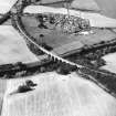
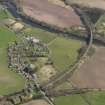
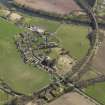
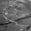
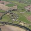
The Roxburgh viaduct carried the Kelso branch line over the River Teviot. The line ran from Tweedsmouth on the Edinburgh to Newcastle line to St Boswells on the Edinburgh to Hawick line.
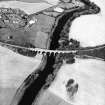
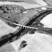
The gently curving viaduct has 13 arches, the largest six spanning the River Teviot. A footbridge still exists at the base of the piers on the downstream side.
Text prepared by RCAHMS as part of the Accessing Scotland's Past project
NT73SW 63 70200 30413
See also NT63SE 23 and NT63SE 40.
For Bridgend Cottages (also known as Railway Cottage and adjacent to ESE), see NT73SW 96.
FB [NAT]
Roxburgh Viaduct [NAT]
OS 1:10,000 map, 1993.
(Location cited as NT 702 304). Roxburgh Viaduct, opened 1850 by the North British Rly. A very fine curved viaduct. There are 6 main segemental arch spans of ashlar construction, flanked on each side by 4 shorter coursed-rubble semi-circular arches. The 3 river piers of the largerspans on the downstream side are extended at a low level to carry a footbridge, with wrought-iron lenticular trusses with cast-iron compression members and a wooden deck.
J R Hume 1976.
Roxburgh Viaduct, 1847, John Miller; this crosses the Teviot just upstream of the old ferry station and Wallace's Tower (NT73SW 31). The curved plan of the viaduct would be impressive enough; the wrought-iron lenticular truss footbridge incorporated into the design at bank level makes this structure more exciting and sophisticated than any provincial railway line has any right to expect. Unfortunately, the railway closed in 1964, and the approich bridge (NT63SE 40) which linked the station (NT63SE 23: now a house) to the viaduct has been demolished.
C A Strang 1994.
This viaduct formerly carried the St Boswells - Sprouston Junction line of the North British Rly over the River Teviot to the E of Roxburgh Station (NT63SE 23). It closed to regular passenger traffic (with the St Boswells - Sprouston Junction - Tweedmouth line) on 15 June 1964.
The location assigned to this record defines the centre of the span. The available map evidence indicates that it extended from NT c. 70105 30401 to NT c. 70304 30429.
Information from RCHAMS (RJCM), 31 January 2006.
G Daniels and L Dench 1980.
Construction (1849 - 1850)
Built to connect the Edinburgh Waverley Line at St Boswells with Kelso.
Project (2007)
This project was undertaken to input site information listed in 'Civil engineering heritage: Scotland - Lowlands and Borders' by R Paxton and J Shipway, 2007.
Publication Account (2007)
This structure is fine example of a large masonry viaduct constructed on a curve with skewed spans. It crosses the Teviot at a height of about 70 ft and was built in 1849–50 by the North British Railway to connect the Edinburgh Waverley line at St Boswells with Kelso. The viaduct’s 14 segmental arches include six skewed
spans of about 46 ft 9 in. (measured on the square) built in coursed rusticated stonework with framed ashlar
pilasters. These skew arches are flanked by four 30 ft straight approach spans built of coursed rubble. The engineer was John Miller and the resident engineer, G. Glennie.
On the north side of the viaduct four piers are extended at a low level above the river to support an iron truss footbridge with three clear spans varying from 49 ft to 52 ft. Each span is simply supported by 4 ft deep bowstring trusses at each side of the deck. The upper chord of the truss is a 5 in. by 1 in. thick flat bar and the tension member is a 112 in. diameter wrought-iron rod. The rod was tensioned by tightening its end nut against the bulbous flat bar end through which it passes. This footbridge also dates from ca.1850 and was almost certainly made and erected by C. D. Young & Co. The railway began operation on 17 June 1850 and was closed in 1968. The viaduct has been recently refurbished and now forms part of The Borders Abbeys Pedestrian Way from Kelso to Jedburgh.
R Paxton and J Shipway 2007
Reproduced from 'Civil Engineering Heritage: Scotland - Lowlands and Borders' with kind permission from Thomas Telford Publishers.
Sbc Note (15 April 2016)
Visibility: Standing structure or monument.
Information from Scottish Borders Council

