
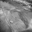
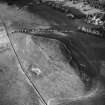
Corbet Tower


Fortified House (Period Unassigned)
Site Name Corbet Tower
Classification Fortified House (Period Unassigned)
Alternative Name(s) Corbet House
Canmore ID 58297
Site Number NT72SE 7
NGR NT 77663 23887
Datum OSGB36 - NGR
Permalink http://canmore.org.uk/site/58297


- Council Scottish Borders, The
- Parish Morebattle
- Former Region Borders
- Former District Roxburgh
- Former County Roxburghshire
NT72SE 7 77663 23887
See also NT72SE 32 Corbet Tower, Country House.
NMRS REFERENCE
Corbet Tower.
This oblong free-standing structure, which stands on the left bank of Corbet Burn within 50ft of the modern mansion, covers so small an area as to suggest that what remains is only part of a larger building; yet the site is restricted except to the W, where at one time there stood an addition, and it is therefore possible that in the first instance the tower was no larger than at present. Measuring externally only 16ft 3in from E to W by 22ft 3in from N to S, it contains three storeys and a garret, all of them modernised internally.
Externally too there has been much alteration, most of the N gable, the whole of the wall-head, the gable crow-steps and the roof all being modern. The restoration was effected by Sir Charles Ker about 1820. (New Statistical Account [NSA] 1845). A plan is given in RCAHMS 1956, fig.433 and an illustration in RCAHMS 1956, fig.50.
The masonry is random rubble with freestone dressings. The entrance, opening to the W, has a moulded architrave and an inscribed lintel, the latter a member of the series mentioned on p.47 (supra); it bears in the centre the sacred monogram IHS flanked by two sets of initials, I B and B K, the last letter mutilated, while the date 1575 appears within a pelta-shaped panel in the upper dexter corner. Above the lintel springs a relieving arch. The only window on the gound floor is a modern one opening to the N, but there are two original oval gun-loops at this level in the E wall, the N one being unpierced and evidently introduced for symmetry. On the first floor an original chamfered window facing W has been built up, while a modern one has been broken out to the N. The built-up doorway in the W. wall was evidently broken out to give access to the upper floor of an addition which no longer exists. Above these openings there are two oval gun-loops; two similar gun-loops face E, and two more, with a small window between and slightly above them, face S. Another gun-loop also appears, at a lower level, on the S side.
At second-floor level a continuous moulded en- corbelment, on which the superstructure is over-sailed, runs along each wall. Above it there are two small windows with moulded margins facing W., while another one, with chamfered margins, faces S and a fourth, which is quite modern, faces E. The inside of the tower is now featureless. Its S half has been filled up by a newel-staircase, probably formed when the W addition was made; but this has been replaced by a modern stair.
By the early 13th century the family of Corbet was already established in the neighbouring estate of Clifton. In 1544 'Corbet House' was burnt by the English under Sir George Bowes, (Letters and Papers, Henry VIII 1544), and The Statistical Account of Scotland (1795) mentions (Letters and Papers, Henry VIII 1544), that "the ruins of Whitton-castle and Corbet-house are the only remains of large buildings or places of strength in the parish" of Morebattle. Towards the close of the 16th century the Kers were lairds of Corbet; Whitton, on the other hand, belonged to the Bennets, as did the neighbouring estate of Grubet. It looks therefore as though the inscribed lintel at Corbet Tower (supra) had strayed thither either from Whitton or from Grubet, as the husband's initials, I B, suggest a Bennet while the wife, B K, may have been a Ker. Blaeu's Atlas marks "Grubethous" immediately N of "Corbetthous".
RCAHMS 1956, visited 5 July 1933.
EXTERNAL REFERENCE:
ORDNANCE SURVEY
Corbet Tower is as described and illustrated.
Visited by OS (EGC) 12 June 1968.
Sbc Note (15 April 2016)
Visibility: Standing structure or monument.
Information from Scottish Borders Council

