
Buchtrig


Scooped Settlement (Middle Iron Age), Settlement (Period Unassigned)
Site Name Buchtrig
Classification Scooped Settlement (Middle Iron Age), Settlement (Period Unassigned)
Canmore ID 58094
Site Number NT71SE 39
NGR NT 7781 1376
Datum OSGB36 - NGR
Permalink http://canmore.org.uk/site/58094


- Council Scottish Borders, The
- Parish Hownam
- Former Region Borders
- Former District Roxburgh
- Former County Roxburghshire
NT71SE 39 7781 1376.
(NT 7781 1376) Enclosure (NR)
OS 6"map, (1962).
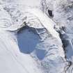
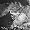
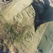
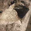
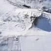
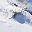
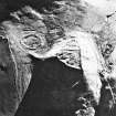
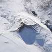
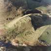
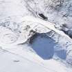
Scooped Enclosure, Buchtrig: At the foot of the N flank of Moat Knowe, there are the remains of a stone- walled enclosure, D-shaped on plan and measuring internally 155' NE-SW by 120'. The wall, which consisted of a rubble core faced on either side with boulders, has totally disappeared on the NE side, and is in a ruinous condition elsewhere. There are two entrances, one at the SW apex and the other on the opposite side; the latter leads into one of two scooped courts, similar in size, which together occupy the greater part of the lower (S) half of the interior. A rectangular building in the E court, now reduced to its foundations, appears to be intrusive since the debris of its E wall overlies the site of the enclosure wall. The upper half of the interior has been terraced, but contains no sign of structures.
Immediately outside the enclosure on the S there is another scooped and walled court, and to the W of this, a curved bank at the S end of which are the remains of a small oval structure, possibly a hut, with an entrance on the NE.
RCAHMS 1956, visited 1947.
As described above.
Visited by OS(WDJ) 7 September 1960.
This "enclosure" is comparable with the scooped settlements of Peeblesshire. Though previously "scooped enclosures" were considered to be of late medieval date, this dating can no longer be sustained, and they have been shown to be of Early Iron Age date.
The designation "scooped enclosure" is itself unsatisfactory. (RCAHMS 1967).
Information from OS recorder (IF) 18 February 1976.
A scooped settlement; no change.
Visited by OS(BS) 1 September 1976.
Field Visit (5 October 1999)
NT71SE 39
Moat Knowe
Scooped Settlement
NT 77805 13780
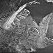
This site was recorded as part of the Kale Water Survey project and is largely as described previously on the date of visit. Additionally, it may be noted that there are three phases of enclosure. Within the NE sector there are the stone footings of a rectangular building (NT 77822 13775) measuring 12.5m from NE to SW by 3.5m in breadth within faced rubble walls 0.4m high and 0.7m thick. The NE end of the building is slightly dished suggesting the possibility of a kiln. The most southerly building (NT 77786 13731) overlies the SW end of the enclosure and is levelled into the slope. It measures 7.8m from NE to SW by 4m transversely within stone and turf banks which measure up to 0.4m in height and 1m in thickness. About 17m E of this, within the enclosure, there is a third subrectangular building (NT 77803 13734) measuring 5m from NW to SE by 3.1m transversely within stone and turf banks up to 0.3m in height.
(KALE99 412-414)
Visited by RCAHMS (DCC) 5 October 1999, with additional information from RCAHMS (BM) 12 June 2012
Sbc Note
Visibility: This is an upstanding earthwork or monument.
Information from Scottish Borders Council

