
Buchtrig


Enclosure (Period Unassigned), Settlement (Period Unassigned)
Site Name Buchtrig
Classification Enclosure (Period Unassigned), Settlement (Period Unassigned)
Alternative Name(s) Moat Knowe
Canmore ID 58079
Site Number NT71SE 25
NGR NT 7795 1360
Datum OSGB36 - NGR
Permalink http://canmore.org.uk/site/58079


- Council Scottish Borders, The
- Parish Hownam
- Former Region Borders
- Former District Roxburgh
- Former County Roxburghshire
NT71SE 25 7795 1360.
(NT 7795 1360) Enclosure (NR)
OS 6"map, (1962).
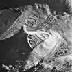
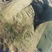
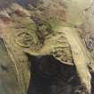
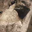
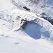
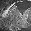
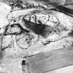
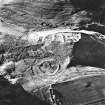
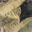
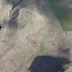
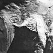
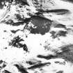
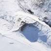
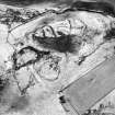
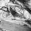
This enclosure, which lies partly on low boggy ground and partly on the foot of Stanshiel Hill, is nearly circular, 150' in diameter, bounded by a massive wall, 7' thick, faced on each side with large boulders, some of which are set on edge and some on bed; the core is composed of rubble. The outer face is well-preserved from place to place for a distance of 150' northwards from the entrance gap on the S. Another, probably later, gap leads through the N arc into a low court which occupies 1/3 of the enclosure. Across the middle of the enclosure, above this court, there stretches a level terrace of uneven width on to which the main entrance gap opens, and above it the highest part of the enclosure merges into the scarped hill-slope. A later field bank runs SW from a point on the SE arc. There is a faint trace of a shallow ditch running round outside the E and S arcs of the enclosure about 20' out from it.
RCAHMS 1956, visited 1947.
Although no definite house platforms were located within this enclosure, which is as described, its situation and construction indicate a settlement.
Visited by OS(WDJ) 7 September 1960 and (DWR) 25 July 1973.
No change to previous information.
Visited by OS(BS) 1 September 1976.
Field Visit (5 October 1999)
NT71SE 25
Moat Knowe
Scooped Settlement; Enclosure
NT 77950 13590
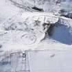
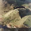
This site was recorded as part of the Kale Water Survey project and is largely as described previously on the date of visit. Measuring 46m in diameter, this scooped settlement is situated on low sloping ground, within an enclosure, between the NW foot of Stanshiel Hill and the SE foot of the fort on Moat Knowe (NT71SE 24). The settlement lies at the E corner of a subrectangular enclosure measuring about 100m from NE to SW by 80m transversely within turf banks. The bank to the SW curves round to the SE in an arc with a diameter of about 55m (from NT 77870 13565 to NT 77910 13527). There is a gap of about 60m at the S corner of the enclosure, where a modern fence runs from WSW to ENE. At the W corner there is another opening about 10m wide; immediately inside this opening an internal bank runs NE for about 25m, parallel to the NW enclosure bank (NT 77880 13572 to NT 77894 13594). Immediately to the W of the entrance a further length of bank partially blocks the entrance and runs intermittently from NE to SW for a distance of about 30m (NT 77867 13568 to NT 77853 13544). A smaller enclosure (NT 77917 13630) extends to the NE from the NE bank of the large enclosure and measures about 21m from NW to SE by 14m transversely; about 6m to the NE of this smaller enclosure, a 40m length of bank runs from WNW to ESE.
Visited by RCAHMS (DCC) 5 October 1999, with additional information from RCAHMS (BM) 12 June 2012
Sbc Note
Visibility: This is an upstanding earthwork or monument.
Information from Scottish Borders Council

