
Blackhall Hill


Cairn(S) (Prehistoric)
Site Name Blackhall Hill
Classification Cairn(S) (Prehistoric)
Canmore ID 58070
Site Number NT71SE 17
NGR NT 7805 1177
NGR Description NT 7805 1177 and NT 7804 1176
Datum OSGB36 - NGR
Permalink http://canmore.org.uk/site/58070


- Council Scottish Borders, The
- Parish Hownam
- Former Region Borders
- Former District Roxburgh
- Former County Roxburghshire
NT71SE 17 7805 1177 and 7804 1176.
(A: NT 7805 1177; B: NT 7804 1176) Cairns (NR)
OS 6"map, (1962).
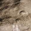
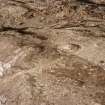
There are two round cairns on the summit of Blackhall Hill. Both are made up of small stones, hardly larger than coarse gravel, and each is encircled by a shallow ditch.
Cairn 'A', the better preserved, has a maximum height of 4'3" above the bottom of the ditch and measures 43'7" in diameter at the base N-S by 42'2". The ditch is from 5' to 6'6" wide and about 1' deep. The top of the cairn, which is flat, has been dug into.
Cairn 'B' is situated on the edge of a precipitous slope, 67' W of 'A'. So much material from its SW side has been thrown down the slope that its diameter cannot be measured from N-S; it is 36' E-W. The cairn stands to a maximum height of 3'3" above the bottom of the ditch, but it has been extensively dug into and is very much dilapidated. The ditch is 5' wide and less than 1' deep.
Crawford, noting the above cairns, suggests that 'B' is a possible Roman signal station.
RCAHMS 1956, visited 1938; OS 6"map, annotated by O G S Crawford 23 June 1934.
These cairns are as described by the RCAHMS. There is no real evidence for 'B' being a Roman signal station.
Visited by OS (WDJ) 13 September 1960.
No change.
Visited by OS (BS) 16 September 1976.
Field Visit (21 September 1999)
NT71SE 17
Blackhall Hill
Cairn
NT 78049 11772
These two cairns are situated on the summit of Blackhall Hill. The larger of the two cairns (NT 78062 11783) measures 12.6m in diameter and stands to a height of 1.5m. It is encircled by a shallow ditch up to 2m in width and a slight counterscarp bank 1m thick. The smaller cairn (NT 78046 11771) sits about 10m to the SW and measures 11.5m in diameter and stands to a height of 1.2m, within a shallow ditch 1.5m in width. The centre of the cairn has been dug into exposing cairn material.
(KALE99 204-205)
Visited by RCAHMS (PJD) 21 September 1999
Sbc Note
Visibility: This is an upstanding earthwork or monument.
Information from Scottish Borders Council

