
Whitberry Point


Enclosure (Period Unassigned)(Possible), Trench(S) (20th Century)
Site Name Whitberry Point
Classification Enclosure (Period Unassigned)(Possible), Trench(S) (20th Century)
Alternative Name(s) World War Ii Defences
Canmore ID 57860
Site Number NT68SW 22
NGR NT 636 813
Datum OSGB36 - NGR
Permalink http://canmore.org.uk/site/57860


- Council East Lothian
- Parish Whitekirk And Tyninghame
- Former Region Lothian
- Former District East Lothian
- Former County East Lothian
NT68SW 22 636 813.
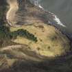
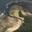
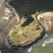
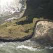
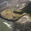
Trapezoidal platform-like feature to the north of cairn NT68SW 4, approximately 150m by 150m. Apparently formed from banked sand, it is only slightly damaged by wartime trenches. The only visible features on the surface are some possibly rigs following the alignment of the platform, NE-SW.
C J Aliaga-Kelly 1985.
A possible enclosure, on a promontory, formed of banked sand with rig on its surface, was identified in 1985. The area was located on the promontory, however no rigs as described could be seen. The area had the appearance of a natural feature. This area has been disturbed by three WW2 slit trenching observed on 1946 AP's, and it is possible that the remains of these were mistaken for earlier features. Two of the three trenches are still extant (see below). No features resembling the enclosure or rig were located on the 1946, 1973, or 1988 AP's. B108 7196-7 15/4/46; B739 009-013; C279 055-7 7/6/88.
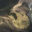
An L-shaped trench around a concrete and rubble mound 25m east of NT 6358 8127. The trench is 0.40m wide at the bottom stepping out to 1.20m at the top. The trench edges are revetted at the bottom by corrugated iron sheeting and by a wire and stake fence at the top. Both trenches are 8m long. This trench visible on 1946 AP's. B108 7196-7 15/4/46.
Site recorded by GUARD during the Coastal Assessment Survey for Historic Scotland, 'The Firth of Forth from Dunbar to the Coast of Fife' 17th February 1996.

