
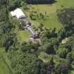
Whittingehame Tower, Burial Ground Of The Balfour Family


Burial Ground (Period Unassigned), Church (Period Unassigned)(Possible)
Site Name Whittingehame Tower, Burial Ground Of The Balfour Family
Classification Burial Ground (Period Unassigned), Church (Period Unassigned)(Possible)
Alternative Name(s) Whittingehame House; Balfour Burial Ground
Canmore ID 57825
Site Number NT67SW 3
NGR NT 6020 7330
Datum OSGB36 - NGR
Permalink http://canmore.org.uk/site/57825


- Council East Lothian
- Parish Whittingehame
- Former Region Lothian
- Former District East Lothian
- Former County East Lothian
NT67SW 3 6020 7330.
(Name centred: NT 6014 7336) Burial Ground (NR) (Site of)
OS 6" map (1957)
Previous to the Reformation, at a date unknown, a church was built on the site of what was (in the 1920's) the Balfour burial ground. It stood for at least 250 years in close proximity to the castle of Whittinghame (NT67SW 2).
Trans E Lothian Antiq Fld Natur Soc 1929
On 7th May 1245 David de Berneham (Birman), Bishop of St Andrews, dedicated a stone church at Whittingehame, the site of which was close to the Tower.
M B Lang 1939
The burial ground of the families of Douglas and Seaton of Whittingham and Hay of Drummellzier was in use from 1300 to 1817. A pillar marks the site of the sepulchre.
Name Book 1853
The Burial Ground of the Balfour family is situated at NT 6020 7330. No trace of the pre-Reformation church remains.
Visited by OS (RD) 31 March 1966
Project (1996 - 2006)
A project recording graveyard monuments within the parish of Traprain.

