|
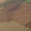
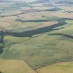
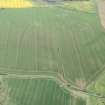
Photographs and Off-line Digital Images |
D 70219 |
RCAHMS Aerial Photography |
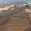
Oblique aerial view centred on the cropmarks of the fort, taken from the N. |
14/6/2000 |
Item Level |
|
|
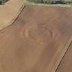
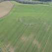
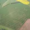
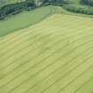
Photographs and Off-line Digital Images |
D 57709 |
RCAHMS Aerial Photography |
Oblique aerial view centred on the cropmarks of the fort, taken from the SSW. |
12/8/1999 |
Item Level |
|
|
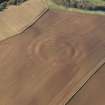
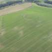
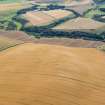
Photographs and Off-line Digital Images |
D 57710 |
RCAHMS Aerial Photography |
Oblique aerial view centred on the cropmarks of the fort, taken from the E. |
12/8/1999 |
Item Level |
|
 |
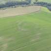
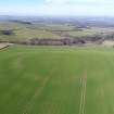
On-line Digital Images |
DP 049837 |
RCAHMS Aerial Photography Digital |
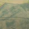
General oblique aerial view of the soilmarks of the fort of The Chesters, Spott, taken from the SW. |
2/11/2008 |
Item Level |
|
 |
On-line Digital Images |
DP 049838 |
RCAHMS Aerial Photography Digital |
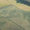
Oblique aerial view of the soilmarks of the fort of The Chesters, Spott, taken from the SE. |
2/11/2008 |
Item Level |
|
 |
On-line Digital Images |
DP 049839 |
RCAHMS Aerial Photography Digital |
General oblique aerial view of the soilmarks of the fort of The Chesters, Spott, taken from the ESE. |
2/11/2008 |
Item Level |
|
 |
On-line Digital Images |
DP 049840 |
RCAHMS Aerial Photography Digital |
General oblique aerial view of the soilmarks of the fort of The Chesters, Spott, with the coast in the distance, taken from the SW. |
2/11/2008 |
Item Level |
|
 |
On-line Digital Images |
DP 049841 |
RCAHMS Aerial Photography Digital |
General oblique aerial view of the soilmarks of the fort of The Chesters, Spott, with the coast in the distance, taken from the SW. |
2/11/2008 |
Item Level |
|
 |
Digital Files (Non-image) |
WP 000773 |
Records of the Royal Commission on the Ancient and Historical Monuments of Scotland (RCAHMS), Edinbu |
Scanned copy of RCAHMS Marginal Land Survey unpublished typescripts (East Lothian). |
1954 |
Item Level |
|
 |
On-line Digital Images |
DP 163230 |
RCAHMS Aerial Photography Digital |
Oblique aerial view of the cropmarks of the fort at The Chesters, Spott, looking SW. |
27/7/2013 |
Item Level |
|
 |
On-line Digital Images |
DP 163231 |
RCAHMS Aerial Photography Digital |
Oblique aerial view of the cropmarks of the fort at The Chesters, Spott, looking S. |
27/7/2013 |
Item Level |
|
 |
On-line Digital Images |
DP 163248 |
RCAHMS Aerial Photography Digital |
General oblique aerial view of the cropmarks of the fort at The Chesters, Spott, looking NNE. |
27/7/2013 |
Item Level |
|
 |
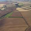
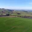
On-line Digital Images |
DP 210885 |
RCAHMS Aerial Photography Digital |
Oblique aerial view of the cropmarks of the fort, looking NW. |
4/5/2015 |
Item Level |
|
 |
On-line Digital Images |
DP 210886 |
RCAHMS Aerial Photography Digital |
Oblique aerial view of the cropmarks of the fort, looking W. |
4/5/2015 |
Item Level |
|
 |
On-line Digital Images |
DP 210887 |
RCAHMS Aerial Photography Digital |
Oblique aerial view of the cropmarks of the fort, looking W. |
4/5/2015 |
Item Level |
|
 |
On-line Digital Images |
DP 210888 |
RCAHMS Aerial Photography Digital |
Oblique aerial view of the cropmarks of the fort and field boundaries, looking SE. |
4/5/2015 |
Item Level |
|
 |
On-line Digital Images |
DP 210889 |
RCAHMS Aerial Photography Digital |
Oblique aerial view of the cropmarks of the fort and field boundaries, looking E. |
4/5/2015 |
Item Level |
|
|
Manuscripts |
MS 36/52 |
Records of the Royal Commission on the Ancient and Historical Monuments of Scotland (RCAHMS), Edinbu |
Field notebook of James Graham Callander (RCAHMS). Title 'East Lothian No. 2'. |
17/6/1913 |
Item Level |
|
 |
On-line Digital Images |
DP 242068 |
Historic Environment Scotland |
Oblique aerial view. |
15/8/2016 |
Item Level |
|
 |
On-line Digital Images |
DP 249956 |
Papers of Dr George F Geddes, archaeologist, Edinburgh, Scotland |
Oblique aerial view |
26/3/2017 |
Item Level |
|
 |
On-line Digital Images |
DP 249957 |
Papers of Dr George F Geddes, archaeologist, Edinburgh, Scotland |
Oblique aerial view |
26/3/2017 |
Item Level |
|
 |
On-line Digital Images |
DP 255976 |
Historic Environment Scotland |
Oblique aerial view. |
14/6/2017 |
Item Level |
|
 |
On-line Digital Images |
SC 1748143 |
RCAHMS Aerial Photography |
Oblique aerial view. |
1988 |
Item Level |
|
 |
On-line Digital Images |
SC 1748144 |
RCAHMS Aerial Photography |
Oblique aerial view. |
1988 |
Item Level |
|


