 |
Digital Files (Non-image) |
WP 004822 |
Records of AOC Archaeology Group, archaeologists, Loanhead, Midlothian, Scotland
|
Digital report associated with archaeological laser scan of Cracknie Souterrain, Tongue |
20/2/2012 |
Item Level |
|
|
Digital Files (Non-image) |
TM 000225 |
Records of AOC Archaeology Group, archaeologists, Loanhead, Midlothian, Scotland
|
Raw survey data associated with archaeological laser survey at Cracknie souterrain, Tongue |
20/2/2012 |
Item Level |
|
|
Digital Files (Non-image) |
TM 000226 |
Records of AOC Archaeology Group, archaeologists, Loanhead, Midlothian, Scotland
|
Raw survey data associated with archaeological laser survey at Cracknie souterrain, Tongue |
20/2/2012 |
Item Level |
|
|
Digital Files (Non-image) |
MV 000788 |
Records of AOC Archaeology Group, archaeologists, Loanhead, Midlothian, Scotland
|
Video footage created from laser scan survey data showing 360 degree rotation inside Cracknie Souterrain, Tongue |
20/2/2012 |
Item Level |
|
|
Digital Files (Non-image) |
MV 000789 |
Records of AOC Archaeology Group, archaeologists, Loanhead, Midlothian, Scotland
|
Video created from laser scan survey at Cracknie Souterrain, Tongue; the camera enters and moves along the passage whilst text provides information about the site and survey. |
20/2/2012 |
Item Level |
|
 |
Digital Files (Non-image) |
WP 004823 |
Records of AOC Archaeology Group, archaeologists, Loanhead, Midlothian, Scotland
|
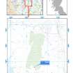
Location map of Cracknie Souterrain, shown in context of wider geographical area in N of Scotland |
20/2/2012 |
Item Level |
|
 |
Digital Files (Non-image) |
WP 004824 |
Records of AOC Archaeology Group, archaeologists, Loanhead, Midlothian, Scotland
|
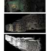
Perspective views of Cracknie souterrain |
20/2/2012 |
Item Level |
|
 |
Digital Files (Non-image) |
WP 004825 |
Records of AOC Archaeology Group, archaeologists, Loanhead, Midlothian, Scotland
|
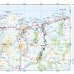
Cracknie heritage context map |
20/2/2012 |
Item Level |
|
|
Digital Files (Non-image) |
GV 006555 |
Records of AOC Archaeology Group, archaeologists, Loanhead, Midlothian, Scotland
|
Ground and reflected ceiling plans and sections of Cracknie Soutterain |
20/2/2012 |
Item Level |
|
|
Digital Files (Non-image) |
GV 006556 |
Records of AOC Archaeology Group, archaeologists, Loanhead, Midlothian, Scotland
|
Internal East, West and Buttress Elevations at Cracknie Souterrain |
20/2/2012 |
Item Level |
|
|
Digital Files (Non-image) |
GV 006557 |
Records of AOC Archaeology Group, archaeologists, Loanhead, Midlothian, Scotland
|
Plans and elevations of Rosal souterrain |
20/2/2012 |
Item Level |
|
 |
Digital Files (Non-image) |
WP 005119 |
Historic Environment Scotland |
Digital copy of Archaeology InSites feature regarding Cracknie Souterrain - Sutherland, Highland |
1/1/2017 |
Item Level |
|


