
Gilliestongues


Fort (Period Unassigned)
Site Name Gilliestongues
Classification Fort (Period Unassigned)
Canmore ID 56883
Site Number NT61NW 17
NGR NT 6372 1659
Datum OSGB36 - NGR
Permalink http://canmore.org.uk/site/56883


- Council Scottish Borders, The
- Parish Jedburgh
- Former Region Borders
- Former District Roxburgh
- Former County Roxburghshire
NT61NW 17 6372 1659
(Centred: NT 63721689) Fort (NR)
OS 6" map, Roxburghshire, (1917-38).
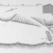
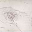
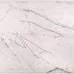
Earthwork, Gilliestongues. This earth-work (Plan, RCAHMS 1956, fig.296), situated 100 yds NW of Gilliestongues farm, occupies the end of a narrow elongated promontory formed by the confluence of the Kye and Swinnie Burns. The site is a strong one since the plateau is raised some 50 ft above the beds of the enclosing burns and is bounded by a precipitous cliff on the greater part of the ESE side, and by steep and occasionally precipitous slopes on the NNE and WNW. The only easy approach to the site is thus along the spur from the SSW.
The earthwork, which is designed to take full advantage of the natural defences, measures 370 ft in length internally along its major axis; its width is not now determinable owing to the total destruction, by cultivation and landslips, of the ramparts on the two longer sides, but this unlikely to have exceeded 150 ft. At the SSW end there can be seen the wasted remains of double, concentric ramparts, bow-shaped on plan and separated by a ditch; these are pierced by a central causeway which probably represents an original entrance. The outer rampart, which now survives only as a truncated fragment on the W side of the causeway, is up to 20 ft thick at the base by 2 ft in height; the ditch, on the same side, is from 12 ft to 15 ft wide at the bottom and 11 ft deep; while the inner rampart has been ploughed down practically to ground level. Tactical considerations demand that the inner rampart should have continued along each of the long sides, and the curve of the ramaining segments is sufficient to allow this. The outer rampart also may have been extended along the edge of the scarp on the WNW; but there is no room for it on the ESE where, as already stated, the cliff forms a formidable obstacle. Both ramparts reappear in a better state of preservation in the wood at the NNE apex of the plateau, the outer mound measuring up to 35 ft in thickness at the base and 10 ft in height and the inner rampart up to 38 ft in thickness and 14 ft in height above the filling at the bottom of the medial ditch. At the foot of the outer rampart there are slight traces of a second ditch, and immediately beyond this two crescentic terraces have been scarped out of the hillside. The ramparts show no trace of built walling, and appear to be constructed simply of heaped earth and stones quarried from the ditches. Former cultivation has destroyed all trace of any structures within the interior, but the terraced track that leads up to the plateau from the Swinnie Burn may possibly be original since there is a similar feature at the comparable site on Worm Rig (RCAHMS 1956, no.34). The earthwork lacks Iron Age characteristics and several features, notably the absence of an external ditch at the SSW end and the resemblance of the ramparts to those at Lintalee (RCAHMS 1956, no.438), suggest a mediaeval date.
RCAHMS 1956.
This feature, generally as described by the RCAHMS, is almost certainly a fort. There seems little doubt that this is an Iron- Age promontory fort.
Resurveyed at 1/2500
Visited by OS (RD) 6 February 1967.
Note (31 August 2015 - 4 August 2016)
This fort is situated on a promontory with steep and precipitous flanks dropping down into the gullies of the Swinnie and Kye Burns on the WNW and ESE respectively, a short distance above their confluence N of Gilliestongues. The defences are drawn in two arcs across both ends of the promontory, but while in 1939 RCAHMS investigators considered that for tactical reasons the inner rampart had probably been carried along the flanks of the promontory (1956, 234-5, no.469), there is no evidence to indicate that this was the case. By then the interior and the SSW end had already been ploughed down, but the central sector of the arc of defences survived, comprising twin ramparts flanking a medial ditch at least 6m in breadth by 3m in depth to either side of a central entrance causeway. At the NNE end there were also traces of an outer ditch, while two terraces cut into the slope below it may indicate others. The interior measures at least 113m from NNE to SSW by up to 45m transversely (0.42ha), but having been heavily ploughed since at least the mid 19th century, more recently it has been subjected to drainage works and planted with trees. In addition to the entrance on the SSW, a terraced trackway drops obliquely SW down the slope to a ford from a point close to the W terminal of the northern defences, leading the RCAHMS investigators to speculate that this possibly marked the position of another original entrance.
Information from An Atlas of Hillforts of Great Britain and Ireland – 04 August 2016. Atlas of Hillforts SC3369
Sbc Note
Visibility: This is an upstanding earthwork or monument.
Information from Scottish Borders Council

