|
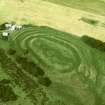
Photographs and Off-line Digital Images |
E 21518 |
Aerial photographs by Wing Commander G S M Insall |
Vertical aerial view of The Chesters, Drem showing the fort and a pit-alignment. |
c. 1930 |
Item Level |
|
|
Photographs and Off-line Digital Images |
E 21519 |
Aerial photographs by Wing Commander G S M Insall |
Vertical aerial view of The Chesters, Drem showing the fort, a circular palisaded settlement, a pit-alignment and the W end of a settlement. |
c. 1930 |
Item Level |
|
 |
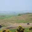
On-line Digital Images |
SC 743508 |
Papers of Helen Cameron Nisbet, geologist and archaeologist, Lasswade, Midlothian, Scotland |
Copy of colour slide showing view of The Chesters fort, Drem East Lothian - defences at west end
NMRS Survey of Private Collection
Digital Image only |
c. 2/1974 |
Item Level |
|
 |
On-line Digital Images |
SC 743512 |
Papers of Helen Cameron Nisbet, geologist and archaeologist, Lasswade, Midlothian, Scotland |
Copy of colour slide showing view of The Chesters fort, Drem East Lothian - defences at west end
NMRS Survey of Private Collection
Digital Image only |
c. 2/1974 |
Item Level |
|
|
Photographs and Off-line Digital Images |
ELD 8/1 P |
Records of the Royal Commission on the Ancient and Historical Monuments of Scotland (RCAHMS), Edinbu |
Publication drawing; plan of fort, Chesters Drem. Photographic copy. |
c. 1920 |
Item Level |
|
 |
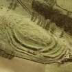
On-line Digital Images |
SC 817813 |
RCAHMS Aerial Photography |
Digital image of an oblique aerial photograph. |
1979 |
Item Level |
|
|
Photographs and Off-line Digital Images |
EL 4058 CS |
RCAHMS Aerial Photography |
Oblique aerial view. |
|
Item Level |
|
 |
On-line Digital Images |
SC 817863 |
RCAHMS Aerial Photography |
Oblique aerial view. |
c. 1979 |
Item Level |
|
|
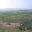
Photographs and Off-line Digital Images |
D 76368 |
RCAHMS Aerial Photography |
Oblique aerial view centred on the remains of the fort with farmsteading adjacent, taken from the SW. |
21/11/2000 |
Item Level |
|
|
Photographs and Off-line Digital Images |
D 76369 |
RCAHMS Aerial Photography |
Oblique aerial view centred on the remains of the fort with farmsteading adjacent, taken from the ESE. |
21/11/2000 |
Item Level |
|
|
Photographs and Off-line Digital Images |
D 76370 |
RCAHMS Aerial Photography |
Oblique aerial view centred on the remains of the fort with farmsteading adjacent, taken from the ENE. |
21/11/2000 |
Item Level |
|
|
Photographs and Off-line Digital Images |
D 76371 |
RCAHMS Aerial Photography |
Oblique aerial view centred on the remains of the fort with farmsteading adjacent, taken from the NE. |
21/11/2000 |
Item Level |
|
|
Photographs and Off-line Digital Images |
D 76372 |
RCAHMS Aerial Photography |
Oblique aerial view centred on the remains of the fort with farmsteading adjacent, taken from the WNW. |
21/11/2000 |
Item Level |
|
|
Photographs and Off-line Digital Images |
D 76373 |
RCAHMS Aerial Photography |
Oblique aerial view centred on the remains of the fort with farmsteading adjacent, taken from the WSW. |
21/11/2000 |
Item Level |
|
|
Photographs and Off-line Digital Images |
D 76374 |
RCAHMS Aerial Photography |
Oblique aerial view centred on the remains of the fort with farmsteading adjacent, taken from the SW. |
21/11/2000 |
Item Level |
|
|
Photographs and Off-line Digital Images |
D 76375 |
RCAHMS Aerial Photography |
Oblique aerial view centred on the remains of the fort with farmsteading adjacent, taken from the SSW. |
21/11/2000 |
Item Level |
|
|
Photographs and Off-line Digital Images |
D 69723 CN |
RCAHMS Aerial Photography |
Oblique aerial view centred on the remains of the fort with farmsteading adjacent, taken from the WNW. |
21/11/2000 |
Item Level |
|
|
Photographs and Off-line Digital Images |
D 69724 CN |
RCAHMS Aerial Photography |
Oblique aerial view centred on the remains of the fort with farmsteading adjacent, taken from the WSW. |
21/11/2000 |
Item Level |
|
|
Photographs and Off-line Digital Images |
D 69725 CN |
RCAHMS Aerial Photography |
Oblique aerial view centred on the remains of the fort with farmsteading adjacent, taken from the SW. |
21/11/2000 |
Item Level |
|
|
Photographs and Off-line Digital Images |
D 69727 CN |
RCAHMS Aerial Photography |
Oblique aerial view centred on the remains of the fort with farmsteading adjacent, taken from the SE. |
21/11/2000 |
Item Level |
|
|
Photographs and Off-line Digital Images |
D 69728 CN |
RCAHMS Aerial Photography |
Oblique aerial view centred on the remains of the fort with farmsteading adjacent, taken from the ESE. |
21/11/2000 |
Item Level |
|
|
Photographs and Off-line Digital Images |
D 69729 CN |
RCAHMS Aerial Photography |
Oblique aerial view centred on the remains of the fort with farmsteading adjacent, taken from the E. |
21/11/2000 |
Item Level |
|
|
Photographs and Off-line Digital Images |
D 69730 CN |
RCAHMS Aerial Photography |
Oblique aerial view centred on the remains of the fort with farmsteading adjacent, taken from the NE. |
21/11/2000 |
Item Level |
|
|
Photographs and Off-line Digital Images |
E 98763 CS |
RCAHMS Aerial Photography |
Oblique aerial view centred on the remains of the fort with farmsteading adjacent, taken from the SE. |
21/11/2000 |
Item Level |
|


