 |
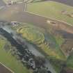
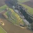
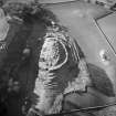
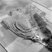
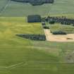
On-line Digital Images |
DP 054913 |
RCAHMS Aerial Photography Digital |
Oblique aerial view centred on the remains of the fort with the farmstead adjacent, taken from the SE. |
4/2/2009 |
Item Level |
|
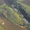 |
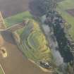
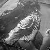
On-line Digital Images |
DP 054914 |
RCAHMS Aerial Photography Digital |
Oblique aerial view centred on the remains of the fort with the farmstead adjacent, taken from the NW. |
4/2/2009 |
Item Level |
|
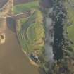 |
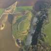
On-line Digital Images |
DP 054915 |
RCAHMS Aerial Photography Digital |
Oblique aerial view centred on the remains of the fort with the farmstead adjacent, taken from the WSW. |
4/2/2009 |
Item Level |
|
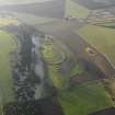 |
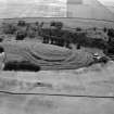
On-line Digital Images |
DP 054916 |
RCAHMS Aerial Photography Digital |
General oblique aerial view centred on the remains of the fort with the farmstead adjacent, taken from the E. |
4/2/2009 |
Item Level |
|
 |
On-line Digital Images |
DP 054917 |
RCAHMS Aerial Photography Digital |
Oblique aerial view centred on the remains of the fort with the farmstead adjacent, taken from the WNW. |
4/2/2009 |
Item Level |
|
 |
On-line Digital Images |
DP 054918 |
RCAHMS Aerial Photography Digital |
Oblique aerial view centred on the remains of the fort with the farmstead adjacent, taken from the W. |
4/2/2009 |
Item Level |
|
 |
On-line Digital Images |
DP 054919 |
RCAHMS Aerial Photography Digital |
Oblique aerial view centred on the remains of the fort with the farmstead adjacent, taken from the WSW. |
4/2/2009 |
Item Level |
|
|
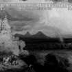
Prints and Drawings |
DC 52966 |
Records of the Society of Antiquaries of Scotland, Edinburgh, Scotland |
Watercolour view of fort at Drem. |
c. 1850 |
Item Level |
|
|
Prints and Drawings |
DC 52965 |
Records of the Society of Antiquaries of Scotland, Edinburgh, Scotland |
Profiles of Drem Hill. |
c. 1850 |
Item Level |
|
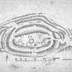 |
On-line Digital Images |
SC 1250787 |
Records of the Royal Commission on the Ancient and Historical Monuments of Scotland (RCAHMS), Edinbu |
Publication drawing; plan of fort, Chesters, Drem. |
c. 1920 |
Item Level |
|
 |
On-line Digital Images |
SC 1250805 |
RCAHMS Aerial Photography |
Oblique aerial view |
1978 |
Item Level |
|
 |
On-line Digital Images |
SC 1250808 |
RCAHMS Aerial Photography |
Oblique aerial view centred on the remains of The Chesters fort, Drem, with Dalvreck farmsteading adjacent, taken from the ENE. |
21/11/2000 |
Item Level |
|
 |
On-line Digital Images |
SC 1250809 |
RCAHMS Aerial Photography |
Oblique aerial view. |
1978 |
Item Level |
|
 |
On-line Digital Images |
SC 1305003 |
RCAHMS Aerial Photography |
Oblique aerial view centred on the remains of The Chesters fort, Drem, with farmsteading adjacent, taken from the NE. |
21/11/2000 |
Item Level |
|
 |
On-line Digital Images |
SC 1305012 |
John Dewar |
Oblique aerial view of the remains of the fort at The Chesters, Drem. |
1973 |
Item Level |
|
 |
Digital Files (Non-image) |
WP 000773 |
Records of the Royal Commission on the Ancient and Historical Monuments of Scotland (RCAHMS), Edinbu |
Scanned copy of RCAHMS Marginal Land Survey unpublished typescripts (East Lothian). |
1954 |
Item Level |
|
|
Manuscripts |
MS 7212 |
Edinburgh Archaeological Field Society (EAFS) |
Report: 'Geophysical survey of two sites adjacent to Chesters Hill Fort, Drem, East Lothian'. |
8/2011 |
Item Level |
|
|
Photographs and Off-line Digital Images |
SC 1386490 |
Aerial photographs by Wing Commander G S M Insall |
Vertical aerial view of The Chesters, Drem showing the fort, a circular palisaded settlement and the W end of a settlement. |
1930 |
Item Level |
|
|
Photographs and Off-line Digital Images |
SC 1386491 |
Aerial photographs by Wing Commander G S M Insall |
Vertical aerial view of The Chesters, Drem showing the fort and a pit-alignment. |
1930 |
Item Level |
|
|
Photographs and Off-line Digital Images |
SC 1386492 |
Aerial photographs by Wing Commander G S M Insall |
Vertical aerial view of The Chesters, Drem showing the fort, a circular palisaded settlement, a pit-alignment and the W end of a settlement. |
1930 |
Item Level |
|
|
Photographs and Off-line Digital Images |
SC 1386495 |
Aerial photographs by Wing Commander G S M Insall |
Vertical aerial view of The Chesters, Drem showing the fort, a circular palisaded settlement and a pit-alignment. |
1930 |
Item Level |
|
 |
Digital Files (Non-image) |
WP 003891 |
Publications by the Royal Commission on the Ancient and Historical Monuments of Scotland |
Exploring Scotland's Heritage: Lothian and the Borders |
1985 |
Item Level |
|
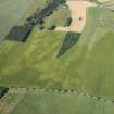 |
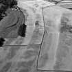
On-line Digital Images |
DP 216699 |
RCAHMS Aerial Photography Digital |
Oblique aerial view of the cropmarks of the ring ditch houses and the pit-defined boundary with The Chesters fort beyond, looking WSW. |
9/7/2015 |
Item Level |
|
 |
On-line Digital Images |
DP 216702 |
RCAHMS Aerial Photography Digital |
Oblique aerial view of the cropmarks of the ring ditch houses and the pit-defined boundary with The Chesters fort beyond, looking S. |
9/7/2015 |
Item Level |
|


