
Drylawhill


Cursus (Neolithic)
Site Name Drylawhill
Classification Cursus (Neolithic)
Canmore ID 56270
Site Number NT57NE 67
NGR NT 59001 77884
NGR Description Centre
Datum OSGB36 - NGR
Permalink http://canmore.org.uk/site/56270


- Council East Lothian
- Parish Prestonkirk
- Former Region Lothian
- Former District East Lothian
- Former County East Lothian
NT57NE 67 5892 7790 to 5925 7798
See also NT57NE 29.
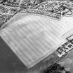
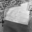
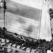
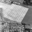
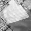
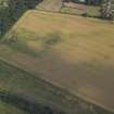
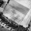
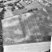
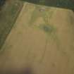
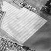
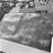
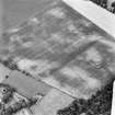
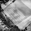
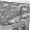
There are two linear cropmarks running parallel, about 90m apart, WSW - ENE across the field to the N of Prestonkirk Parish Church. The first runs from 5892 7790 to 5925 7798 and the second from 5895 7781 to 5916 7787. These may be part of a cursus.
Information from RCAHMS (MMB, RHM) 1 September 1993.
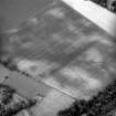
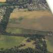
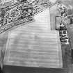
During the re-examination of aerial photographs taken by the RCAHMS in 1981 a series of cropmarks recorded as linear features were identified as the remains of a cursus and associated features (NT57NE 27 and NT57NE 67 -9). The remains lie in an arable field immediately N of Prestonkirk parish church in East Linton.
The principal identifiable features are two parallel ditches running approximately E to W some 60m apart. The ditches vary in width from 2m to 3m and follow a somewhat erratic course, giving the impression of having been constructed in discrete lengths rather than as a single unitary construction. This variability of width and segmented construction are characteristic of cursus monuments. The ditches can be traced for a length of almost 300m, and undoubtedly extend into the field to the E, although no cropmarks are visible there to enable their full extent to be assessed.
N of the W part of the cursus is a series of ditches of uncertain purpose which appear to represent parts of the same complex. These may represent parts of a rectilinear enclosure some 50m N to S by 60m with an internal annular enclosure.
The cursus is the first to be recognised in SE Scotland and the presence of associated features suggest a possible complexity rarely paralleled on cursus monuments elsewhere.
Sponsor: Historic Scotland
I Armit 1993.
This cursus is plotted on a distribution map of Neolithic monuments covering southern Scotland (RCAHMS 1997, 115, fig. 110).
Information from RCAHMS (ARG), 7 April 1998
This cursus monument has a similar character to the cropmark of a possible cursus on the same alignment 470m to the ENE (NT57NE 29), and they may form parts of the same cursus.
Information from RCAHMS (KB) 6 April 1999
Aerial Photographic Transcription (12 August 1993)
An aerial transcription was produced from oblique aerial photographs. Information from Historic Environment Scotland (BM) 31 March 2017.
Desk Based Assessment (8 February 2002)
Headland Archaeology undertook an assessment of archaeological issues affecting a proposed area of development at Drylawhill, East Linton.
This 24 ha site on the north side of the village has been identified by East Lothian Council as a potential site for approximately 350 houses.
None of the archaeological features have been subject to field evaluation so the level of knowledge about specific features is low. However, the majority of the development site lies within the limits of a scheduled ancient monument and therefore the archaeological features are, de facto, of national importance.
Headland Archaeology 2002
Note (7 June 2023)
The location, classification and period of this site have been reviewed and changed from CURSUS (NEOLITHIC), LINEAR FEATURE(S) (PERIOD UNASSIGNED).

