
West Morriston


Fort (Prehistoric)
Site Name West Morriston
Classification Fort (Prehistoric)
Canmore ID 55942
Site Number NT54SE 5
NGR NT 5990 4080
Datum OSGB36 - NGR
Permalink http://canmore.org.uk/site/55942


- Council Scottish Borders, The
- Parish Legerwood
- Former Region Borders
- Former District Ettrick And Lauderdale
- Former County Berwickshire
NT54SE 5 5990 4080.
(NT 5990 4078) Earthwork (NR) (site of)
OS 6" map (1968)
This 'fort' is situated in arable land at an elevation of some 530ft OD. It has been oval, measuring some 414ft by 366ft within two parallel earthen ramparts now greatly effaced. Two ditches are clearly traceable. RCAHMS 1915, visited 1910; J H Craw 1925
This earthwork, formerly situated on the E edge of a low-lying ridge, is now ploughed out, only a slight scarp remaining, on the N, S and E sides. It does not appear to have been defensive.
Visited by OS (JD) 20 May 1955
Previous field report confirmed. Only traces of a slight scarp remain, most noticeable on the E side.
Visited by OS (WDJ) 4 October 1962
Photographed by the RCAHMS in 1983, 1986, 1989, 1991, 1993, 1994, 1996, 1998 and 1999.
Field Visit (May 1910)
243. Fort, West Morriston.
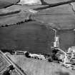
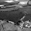
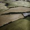
This fort (fig. 119 [DP 228315]), situated on arable land some 250 yards west of West Morriston cottages, at an elevation of some 530 feet above sea-level, has been oval, measuring interiorly some 414 feet by 366 feet, and has been surrounded by two parallel ramparts of earth now greatly effaced.
RCAHMS 1915, visited May 1910.
OS Map: Ber., xxvi. NE.
Note (16 January 2016 - 18 October 2016)
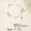
This fort, which lies on a low ridge WSW of West Morriston, was ploughed down before the middle of the 19th century, but fragments of its defences were planned on the ground by James Hewat Craw about 1910 (RCAHMS 1915, 127, No.243, fig 119), and traces of the entire circuit of a single rampart have been revealed by aerial photography in oblique evening sunlight. Still under cultivation, however, the overall plan has been recovered by cropmarks, which reveal that the visible circuit of rampart accompanies the outer, and broader, of two ditches, all trace of the inner and its rampart having been entirely levelled. This inner enclosure measures about 100m from E to W by about 90m transversely within a ditch between 4m and 5m in breadth (0.7ha); allowing for the presence of an inner rampart, its interior extended to about 0.59ha. Entrance gaps are visible on the ESE, SSW and W, though that on the SSW is spanned by a narrower ditch and appears to have been blocked. The entrances broadly coincide with those in the outer circuit, which was clearly much more substantial, not only in the sense that traces of its rampart have survived prolonged cultivation, but its ditch is consistently 6m or more in breadth and its thick internal rampart encloses an area measuring about 130m from E to W by 105m transversely (1ha). It too has three entrances, broadly matching those of the inner circuit. The one on the ESE appears relatively simple, a wide gap directly outside the causeway through the inner ditch, but Craw's plan reveals that fragments of a counterscarp rampart formerly survived here, and the very width of the gap may be an indication that the ramparts returned and united around the terminals of the ditch. In contrast, the terminals of ditch at the SSW entrance are staggered so that the end of the rampart on the W side opposes the terminal of the ditch on the E, effectively creating an overlap that exposes the visitor's right side. Arcs of ditch creating an external lobe on the E side of this gap may represent an attempt to further elaborate the entrance, though not to the extent of the W entrance, Here, what is either a hornwork or a forework is set out in front of a very wide gap in the ditch, though the shadow pictures suggest that main rampart continued without deviating beyond the point where the cropmark of the ditch peters out. The outwork springs from the S side of this gap, swinging round in an L-shaped arrangement to oppose the out-turned N terminal of the main ditch; if continuous, this spur of ditch is a hornwork, but there is a possible causeway across its southern end, which would have created a second approach to the gap in the main rampart. The arrangement is evidently complex and cannot be fully understood without excavation, but the stubs of two ditches can be seen on the inner side of the possible causeway, and the southern also marks a major contraction in the breadth of the main ditch; these features almost certainly reflect several phases of construction and re-cutting of the ditches. Within the interior at least five separate maculae can be detected, the more circular of them representing the stances of round-houses, but it is noticeable that several impinge on the line of the inner circuit, raising the question of when it was demolished. Examined in detail, the two circuits are not strictly concentric, and nor are the entrances on the SSW and W directly aligned, access to the latter at the very least hampered by the presence of the outer rampart. These features and the way that the shadow pictures only reveal traces of the outer circuit suggest that the inner was demolished in antiquity to make way for the larger outer circuit.
Information from An Atlas of Hillforts of Great Britain and Ireland – 18 October 2016. Atlas of Hillforts SC4004
Sbc Note (21 March 2016)
Visibility: This was the site of an archaeological monument, which may no longer be visible.
Information from Scottish Borders Council

