 |
On-line Digital Images |
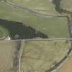
DP 013630 |
RCAHMS Aerial Photography Digital |
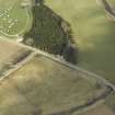
Oblique aerial view centred on the gates with the caravan site and road bridge adjacent, taken from the SSE. |
10/4/2006 |
Item Level |
|
 |
On-line Digital Images |
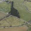
DP 013631 |
RCAHMS Aerial Photography Digital |
Oblique aerial view centred on the gates with the caravan site, road bridge and stable adjacent, taken from the ESE. |
10/4/2006 |
Item Level |
|
 |
On-line Digital Images |
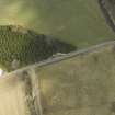
DP 013632 |
RCAHMS Aerial Photography Digital |
Oblique aerial view centred on the gates with the caravan site and road bridge adjacent, taken from the SSE. |
10/4/2006 |
Item Level |
|
 |
On-line Digital Images |
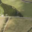
DP 013633 |
RCAHMS Aerial Photography Digital |
Oblique aerial view centred on the gates with the caravan site and road bridge adjacent, taken from the SE. |
10/4/2006 |
Item Level |
|
 |
On-line Digital Images |
DP 013634 |
RCAHMS Aerial Photography Digital |
Oblique aerial view centred on the gates with the caravan site and road bridge adjacent, taken from the ESE. |
10/4/2006 |
Item Level |
|
 |
On-line Digital Images |
SC 2450177 |
Records of the Ordnance Survey, Southampton, Hampshire, England |
Lauder Bridge, NT54NW 70, Ordnance Survey index card, Recto |
1958 |
Item Level |
|


