
Old Thirlestane Castle


Castle (Medieval)
Site Name Old Thirlestane Castle
Classification Castle (Medieval)
Canmore ID 55792
Site Number NT54NE 11
NGR NT 56493 47382
Datum OSGB36 - NGR
Permalink http://canmore.org.uk/site/55792


- Council Scottish Borders, The
- Parish Lauder
- Former Region Borders
- Former District Ettrick And Lauderdale
- Former County Berwickshire
Field Visit (12 August 1908)
210. Old Thirlestane Castle.
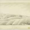
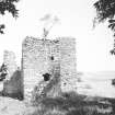
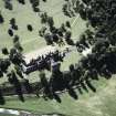
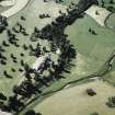
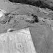
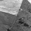
Old Thirlestane Castle, which is situated on the Boondreigh Water, to the south of Thirlestane farm and about 2 miles east of Lauder, has been a rectangular keep, measuring 33 feet by 24 feet, with a wing projecting westwards containing the staircase, 11 feet 6 inches long by 14 feet 5 inches broad. The walls are 3 feet 6 inches in thickness, and the masonry of rough undressed channel stones. It is now much ruined. Only the south wall of the keep and a portion of the wing remain standing. The circular depression noted (op. cit.) at the top of the bank 170 yards to the north-east has probably been a lime kiln.
See Ber. Nat. Club, 1901-2, p. 288 (plan and illus.); ibid., p. 267.
RCAHMS 1915, visited 12th August 1908.
OS Map: Ber., xx. NW.
Field Visit (15 February 1955)
As stated by the RCAHMS, only the S wall of the keep and a portion of the wing remain standing to a height of some 8m. Although it is stated that the tower existed in the 13th century, it resembles more the normal rectangular keep erected in the 15th - 16th century. Owing to deeply drifting snow the enclosures mentioned above were not traceable.
Visited by OS (JFC) 15 February 1955
Desk Based Assessment (1955)
NT54NE 11 56493 47382
For Thirlestane Castle at NT 5338 4790 see NT54NW 7
(NT 5649 4738) Thirlstane Castle (NR) (remains of)
OS 6" map (1968)
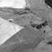
Old Thirlestane Castle was an ordinary border keep, rectangular on plan, measuring 33ft by 24ft, with a wing projecting westwards containing the staircase, 11ft 6ins long by 14ft 5ins broad. The 3ft 6ins thick walls are of rough, undressed stones. It is now much ruined, only the S wall of the keep and part of the wing remaining. The lower part of the tower was vaulted. The enclosures visible around the castle appear to have been for keeping cattle rather than for defence. However, the heavy mound to the NW of the tower appears to be part of the original outer court wall.
The original tower was the property and residence of Sir Richard Maitland in the mid-13th century, and was occupied by his successors till about 1595, when the present Thirlestane Castle (NT54NW 7) was built.
T Martin 1904; F Lynn 1904; RCAHMS 1915, visited 1908; D MacGibbon and
T Ross 1892; A Thomson 1902
Information from Ordnance Survey Index Card.
Field Visit (4 October 1962)
The remains of this castle are generally as described by the previous authorities. The extensive mounds near the castle differ somewhat in plan from that given by Lynn, probably due to subsequent mutilation. They consist for the most part of banks and scarps of grassed-over stone or rubble walling varying in height from 0.2 to 0.6m. Some form the outline of buildings.
Surveyed at 1:2500.
Visited by OS (RDL) 4 October 1962
External Reference (9 September 2015)
The entry in the Schedule of Monuments relating to this monument was amended in 2015.
Information from Historic Scotland, 9th September 2015
Sbc Note
Visibility: Upstanding structure, which may not be intact.
Information from Scottish Borders Council.

