
Huntly Burn


Earthwork (Period Unknown), Stock Enclosure (Possible), Track (Post Medieval)
Site Name Huntly Burn
Classification Earthwork (Period Unknown), Stock Enclosure (Possible), Track (Post Medieval)
Canmore ID 55770
Site Number NT53SW 6
NGR NT 5237 3230
Datum OSGB36 - NGR
Permalink http://canmore.org.uk/site/55770


- Council Scottish Borders, The
- Parish Bowden
- Former Region Borders
- Former District Ettrick And Lauderdale
- Former County Roxburghshire
NT53SW 6 5237 3230.
(NT 5237 3230) Earthwork (NR)
OS 6" map (1967)
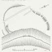
This earthwork lies at 800 ft OD on the gentle N slope of Bowden Moor, and is flanked by the left bank of the Huntly Burn which here runs through a defile 40 ft deep. The remains now consist of a C-shaped earthen bank, the E side of the earthwork being defined only by the lip of the defile. The earthwork is 200 ft from N to S by about 125 ft wide. The bank, still 5 ft high at the N and S ends, has been reduced by cultivation on the W side to a low terrace. At the SE corner, where the bank is spread to a width of 22 ft, there is a short length of external ditch, 20 ft wide. At the N end the bank stops short 20 ft from the lip of the defile with what appears to be an original rounded end. There are no internal features.
The earthwork, which is crossed from N to S by a track, was probably a cattle-pen placed beside the burn at the N limit of an area of rough grazing land.
RCAHMS 1956, visited 1948
This earthwork is as described above. The position is a commanding one, and the nature of the work itself gives the impression that is was defensive rather than pastoral.
Surveyed at 1:2500.
Visited by OS (WDJ) 7 February 1961
Note (24 August 2015 - 14 November 2016)
This small fort or fortified settlement is situated in a clearing in a coniferous plantation above the W bank of the Huntly Burn, which here runs in a gully over 10m deep. Roughly D-shaped on plan, backing onto the lip of the gully on the E, where there is no trace of any other defences, it measures about 67m from NE to SW by a maximum of 30m transversely within a single rampart up to 6.5m in thickness by 1.5m in height, with an external ditch up to 6m in breadth. The rampart is best preserved on the NNE and S, having been ploughed down and reduced to a scarp on the W, while the ditch is still visible on the S. The entrance was probably on the NE, where the rampart terminates short of the edge of the gully. Apart from a hollowed trackway that traverses the enclosure from N to S, the interior is featureless.
Information from An Atlas of Hillforts of Great Britain and Ireland – 14 November 2016. Atlas of Hillforts SC3329
Sbc Note
Visibility: This is an upstanding earthwork or monument.
Information from Scottish Borders Council

