
Rock Plantation


Enclosure (Period Unassigned)(Possible), Fort (Period Unassigned)(Possible), Linear Feature(S) (Period Unassigned)
Site Name Rock Plantation
Classification Enclosure (Period Unassigned)(Possible), Fort (Period Unassigned)(Possible), Linear Feature(S) (Period Unassigned)
Alternative Name(s) Chester Craig
Canmore ID 55456
Site Number NT52SE 14
NGR NT 5959 2318
Datum OSGB36 - NGR
Permalink http://canmore.org.uk/site/55456


- Council Scottish Borders, The
- Parish Ancrum
- Former Region Borders
- Former District Roxburgh
- Former County Roxburghshire
NT52SE 14 5959 2318.
(NT 5959 2318) Probable Dark Age Fort. The remains have been heavily robbed and are extremely slight. The site was first noted by G O Wood, of Thornbank, Denholm, Hawick.
Information from a letter and plan to K A Steer 9 January 1958
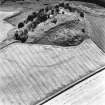
The site is mainly a large rocky spur with vague indications of a rampart wall on the edge of, and connecting, stretches of outcropping rock. The rock outcrop itself, at varying levels, has served as part of the defences. On the lowest terrace, on the SE side, is a massive bank of earth and stone, running N-S, sealing off the terrace on the E. The 'hut' floors shown on the RCAHMS plan appear to be the result of surface quarrying. The remains are too slight for survey at 1:2500; and there is no real evidence for dating it to the Dark Ages, other than by comparison with such greater forts such as Dalmahoy, Midlothian, or even the nearby 'Dunion'.
Visited by OS (EGC) 3 March 1967
No indisputable evidence of antiquity was discerned in long grass at the date of visit. The situation has strong natural defences, but has been re-sculpted by extensive quarrying and the construction of (presumably related) trackways. The 'rampart' that is noted by the Ordnance Survey may be identified with a revetted stone dyke, and the suggested house-platforms are apparently defined by fortuitous scarps.
Visited by RCAHMS (RM/JRS) 28 September 1993.
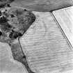
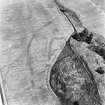
Recent aerial photography (RCAHMSAP 1995) has revealed a series of cropmarks immediately to the NNW side of the fort. A linear cropmark forming an arc of ditch towards the fort is visible for at least 230m and is aligned E-W curving to the SW. This cropmark appears to enclose a possible enclosure and other linear cropmarks visible to the S of it and to the N of the fort. The two visible sides of the enclosure suggest that it measure at least 50m SW-NE by 30m transversely within a broad ditch. Immediately to the NW a series of narrow linear cropmarks are visible, possibly forming another enclosure. The relation between these cropmarks and the possible fort are not clear and can not be confirmed by aerial photography alone.
Information from RCAHMS (KJ) 5 November 1999.
Note (20 August 2015 - 9 August 2016)
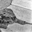
What may be a fort situated on the spur overlooking the top of Chesters Glen has had a chequered history of recording, so much so that there is some doubt as to what remains visible on the ground. Omitted from the RCAHMS County Inventory, it was first noted about 1958 and subsequently planned by RCAHMS investigators in 1961, apparently comprising traces of a heavily-robbed rampart extending along the edge of the crag and linking up outcrops. In 1967 the OS detected only vague traces of a rampart, which they regarded as too slight to appear on the 1:2500 scale map, and a subsequent visit in 1993 by RCAHMS investigators found the site under long grass and, while noting extensive evidence of quarrying on the outcrop, did not locate the rampart. As planned in 1961 (RCAHMS RXD 315/1; DC31519-21), it comprises three contiguous enclosures occupying the rectilinear summit area of the outcrops and a slightly lower terrace on the NE and enclosing a total area measuring about 150m from NE to SW by 30m transversely, with traces of another enclosure taking in a patch of rough ground to the NW and others taking in a terrace on the slope below the summit area on the SE. These latter, which were examined by the OS, were dismissed by other RCAHMS investigators in 1993; they considered the principal feature crossing NE end of the the terrace to be no more than the revetment of an old dyke. The seven platforms in the rough ground to the NW were thought to be surface quarries and fortuitous scarps.
Whether any of these features are the remains of fortifications can only be demonstrated by excavation, but cropmarks have revealed other features that suggest the presence of a much larger fort occupying the spur. Its defences comprise a ditch about 4m in breadth, which springs from the edge of the escarpment on the NE and extends westwards in a broad arc to peter out at the edge of the field on the NW. The area enclosed against the scarp edge is roughly D-shaped on plan and measures about 220m from NE to SW along the chord by at least 130m transversely, not only taking in the enclosures on the summit of the outcrops, but also the rough ground on the NW. Apart from the enclosures on the summit, the only features visible within the interior are an angle of ditch about 6m broad, which forms an enclosure in the angle between the rough ground and the outcrops and measures internally about 50m from NE to SW by 45m transversely; traces of other enclosure ditches lie immediately to its NW.
Information from An Atlas of Hillforts of Great Britain and Ireland – 09 August 2016. Atlas of Hillforts SC3318
Sbc Note
Visibility: This is an upstanding earthwork or monument.
Information from Scottish Borders Council

