
Longfaugh


Fort (Prehistoric), Coin Hoard (Roman)
Site Name Longfaugh
Classification Fort (Prehistoric), Coin Hoard (Roman)
Canmore ID 54796
Site Number NT46SW 10
NGR NT 4038 6176
Datum OSGB36 - NGR
Permalink http://canmore.org.uk/site/54796


- Council Midlothian
- Parish Crichton
- Former Region Lothian
- Former District Midlothian
- Former County Midlothian
NT46SW 10 4038 6176
See also NT46SW 19.
(NT 4038 6176) Fort (NR)
OS 6" map (1971)
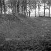
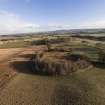
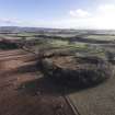
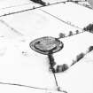
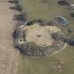
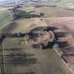
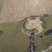
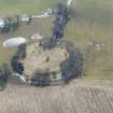
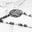
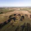
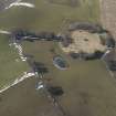
The remains of this circular fort stand on the ridge W of Longfaugh farmhouse. The defences originally consisted of two heavy concentric ramparts apparently constructed of earth heaped up from the ditch between them and faced with stone or timber.
Macdonald refers to twelve Roman coins found about 1785, probably from here.
R W Feachem 1963; RCAHMS 1929; G Macdonald 1918
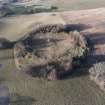
This fort is generally as discribed. It appears to have originally measured about 130.0m in diameter, the entrance probably having been in the E side. The inner rampart remains to a height of 3.0m in the W, where it is best preserved.
Visited by OS (BS) 30 July 1975
Field Visit (29 July 1913)
Fort, Longfaugh.
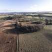
On the summit of a slight eminence planted with trees, on gently rising ground about 500 yards west of Longfaugh Farm, and at an elevation of 800 feet above sea-level, is a roughly circular fort (Fig.102) surrounded by the remains of two earthen ramparts, the interior dimensions being on an average 275 feet from east to west and 250 feet from north to south. The inner rampart, rising in places 5 feet above the inner level, is raised on the edge of the scarp, which shows a height of 13 to 15 feet. The distance between the crests of the ramparts is on an average 57 feet at the north and 54 feet at the south. The outer rampart is entirely obliterated on the west, south, and northeast. Of the sections left on the east the most complete measures approximately 24 feet in breadth, 4 feet 6 inches in height on the inside, and 11 feet on the outside. In other parts, where a modern dyke has encroached, the outer rampart rises from 4 to 5 feet 6 inches above the interior and 6 to 8 feet above the field outside. For a distance of some 180 feet on the east the inner defence is quite destroyed, and opposite the southern extremity of this gap, where the outer rampart also shows a break, there may possibly have been an entrance. Some 65 feet to the south of this supposed entrance the outer rampart bifurcates, as shown on plan.
Twelve Roman bronze coins of the late emperors, which were said to have been found ‘in a Roman encampment on the estate of Crichton-dean’, were presented to the Society of Antiquaries of Scotland in 1785, and others are reported to have been picked up in the immediate vicinity. With regard to these finds, however, see Proc. Soc. Ant. Scot., lii (1917-8), pp. 212-3 and 272. The 6-inch O.S. map also records the finding of a bronze patella at a site almost midway between Longfaugh and Crichton Dean.
RCAHMS 1929, visited 29 July 1913.
OS map: xv N.W.
Field Visit (24 May 1955)
There is nothing to add to the Inventory account and plan. The work is probably an Early Iron Age fort and appears to belong to the circular type common in East Lothian (e.g. Kidlaw [NT56SW 1]).
Visited by RCAHMS (KAS), 24 May 1955.
Note (1988)
Longfaugh NT 4038 6176 NT46SW 10
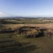
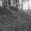
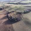
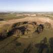
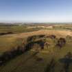
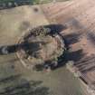
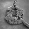
About 500m W of Longfaugh farmhouse a substantial fort is situated on a knoll at the E end of a ridge of higher ground. Circular on plan, it measures about 70m in diameter within two ramparts and a broad medial ditch; the inner rampart rises up to 4.5m above the bottom of the ditch but the outer is reduced to little more than a scarp. The entrance, which has been severely damaged, is on the E and appears to have been· protected by a hornwork springing from the outer rampart a short distance to the S. The interior is occupied by a mature plantation of beech trees, some of which have been blown down causing severe damage. An 18th-century find of Roman coins (NT46SW 19) may have come from this fort.
RCAHMS 1988
(RCAHMS 1929, 52, no. 60; Feachem 1977, 137)
Note (20 November 2015 - 24 May 2016)
This fort occupies a low hillock which had been incorporated into a roundel in the designed landscape around Longfaugh by the mid 18th century. Oval on plan, it measures about 88m from NE to SW by 75m transversely (0.5ha) within twin ramparts with a broad medial ditch. Both ramparts have been mutilated at various points around the circuit, the outer overlain by the plantation boundary, but where best preserved the inner still stands 1.5m high internally and up to 4.5m externally above the bottom of the ditch. The entrance was probably on the E, where a large sector of the inner rampart has been largely levelled, but the purpose of another bank between the two ramparts on the S side of this gap is unknown. The interior is featureless.
Information from An Atlas of Hillforts of Great Britain and Ireland – 24 May 2016. Atlas of Hillforts SC3767

