 |
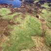
On-line Digital Images |
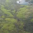
DP 080264 |
RCAHMS Aerial Photography Digital |
General oblique aerial view of the township buildings, dykes, rig and hut-circles at Dola, taken from the SE. |
29/5/2009 |
Item Level |
|
 |
On-line Digital Images |
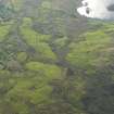
DP 080265 |
RCAHMS Aerial Photography Digital |
General oblique aerial view of the township buildings, dykes, rig and hut-circles at Dola, taken from the SE. |
29/5/2009 |
Item Level |
|
 |
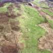
On-line Digital Images |
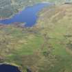
DP 080314 |
RCAHMS Aerial Photography Digital |
General oblique aerial view of the buildings, dykes, rig and hut-circles at Dola looking towards Loch Craggie, taken from the W. |
29/5/2009 |
Item Level |
|
 |
On-line Digital Images |
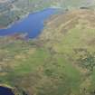
DP 080315 |
RCAHMS Aerial Photography Digital |
General oblique aerial view of the buildings, dykes, rig and hut-circles at Dola looking towards Loch Craggie, taken from the W. |
29/5/2009 |
Item Level |
|
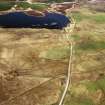 |
On-line Digital Images |
SC 1906825 |
Papers of James Sloan Bone, landscape historian, Inverness, Highland, Scotland |
An oblique aerial view of Loch Dola, Lairg, Sutherland, looking NE. |
2000 |
Item Level |
|
 |
On-line Digital Images |
SC 1906848 |
Papers of James Sloan Bone, landscape historian, Inverness, Highland, Scotland |
An oblique aerial view of Dola, Lairg, Sutherland, looking SE. |
2000 |
Item Level |
|
 |
On-line Digital Images |
SC 1906849 |
Papers of James Sloan Bone, landscape historian, Inverness, Highland, Scotland |
An oblique aerial view of Dola, Lairg, Sutherland, looking SE. |
2000 |
Item Level |
|
 |
On-line Digital Images |
SC 2347784 |
Records of the Ordnance Survey, Southampton, Hampshire, England |
Dola, NC60NW 4, Ordnance Survey index card, page number 1, Recto |
1958 |
Item Level |
|
 |
On-line Digital Images |
SC 2347785 |
Records of the Ordnance Survey, Southampton, Hampshire, England |
Dola, NC60NW 4, Ordnance Survey index card, page number 2, Verso |
1958 |
Item Level |
|


