
Dola


Head Dyke (Post Medieval), Kiln(S) (Period Unassigned), Township (Period Unassigned)
Site Name Dola
Classification Head Dyke (Post Medieval), Kiln(S) (Period Unassigned), Township (Period Unassigned)
Canmore ID 5456
Site Number NC60NW 4
NGR NC 609 075
Datum OSGB36 - NGR
Permalink http://canmore.org.uk/site/5456


- Council Highland
- Parish Lairg
- Former Region Highland
- Former District Sutherland
- Former County Sutherland
NC60NW 4 609 075.
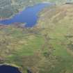
(Area NC 6090 0757) Dola (NAT)
OS 6"map, Sutherlandshire, 2nd ed., (1908)
Doler: shown as a settlement of five buildings with arable.
W Roy 1747-55.
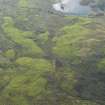
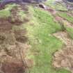
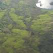
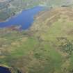
Within a prominent bank are the footings of twenty-two buildings, four kilns, and associated enclosures. The building walls are some 0.9m thick and average 0.4m high. The buildings vary in size from 35m by 4m to 8m by 4m.
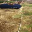
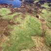
An area of depopulation centred NC 6080 0723 contains eight buildings, a kiln and associated enclosures. The remains of the buildings consist of the wall footings, 0.4m high on average, the walls being some 0.9m thick. The buildings vary in size from 22m by 4m to 4m by 3m.
Surveyed at 1:10,560.
Visited by OS (W D J) 2 July 1963.
No change to the previous field report.
Revised at 1:10,000.
Visited by OS (J B) 5 December 1980.
A township, comprising six unroofed building, one enclosure, a field-system and a head-dyke, is depicted on the 1st edition of the OS 6-inch map (Sutherland 1879, sheet xcv). One roofed building, twenty-four unroofed structures, of which twenty are buildings, nine enclosures, a field-system and a head-dyke are shown on the current edition of the OS 1:10,000 map (1992).
Information from RCAHMS (AKK) 20 November 1995.

