
Dola


Cairn(S) (Period Unassigned), Hut Circle(S) (Prehistoric)
Site Name Dola
Classification Cairn(S) (Period Unassigned), Hut Circle(S) (Prehistoric)
Canmore ID 5441
Site Number NC60NW 26
NGR NC 614 076
NGR Description Centred NC 614 076
Datum OSGB36 - NGR
Permalink http://canmore.org.uk/site/5441


- Council Highland
- Parish Lairg
- Former Region Highland
- Former District Sutherland
- Former County Sutherland
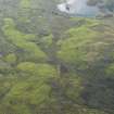
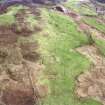
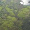
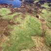
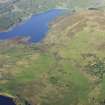
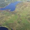
NC60NW 26 centred 614 076.
Centred at NC 614 076 are three closely grouped hut circles ('A' - 'C'), situated on a S-facing slope below an eminence on ground also settled in early-modern times. 'A' is set into the slope in the N, and measures 11.0m in diameter within a turf-covered wall spread to 2.0m and 0.4m internal height. A gap in the S is probably the entrance although it may be quarrying executed during the construction of a later, small sheiling-like footing which obscures the wall in the SW. 'B' is set into the slope in the N and E. It is turf and heather-covered and measures 7.5m N-S by 6.5m internally. Although the wall is clearly indicated being spread from 2.5m - 3.0m and 0.5m high it is ill-defined owing to its spread and slumped nature; its remains are rather angular in the NW. 'C' is strongly built and heather-covered. It measures 9.0m N-S by 8.5m within a wall spread from 2.0m - 2.5m and 0.5m high internally, but 1.1m high externally in the NE.
The entrance in the S is marked by two large blocks on either side. Later cultivation has overlaid much of the area, but some obviously contemporary clearance heaps occur particularly around 'C'.
Surveyed at 1:10,000.
Visited by OS (J B) 7 October 1980.

