
Whytbank Tower


Tower (Medieval)
Site Name Whytbank Tower
Classification Tower (Medieval)
Alternative Name(s) Whytebank Tower
Canmore ID 54409
Site Number NT43NW 3
NGR NT 44186 37668
Datum OSGB36 - NGR
Permalink http://canmore.org.uk/site/54409


- Council Scottish Borders, The
- Parish Caddonfoot
- Former Region Borders
- Former District Ettrick And Lauderdale
- Former County Selkirkshire
NT43NW 3 44186 37668
NT43NW 3.01 4415 3758 Buildings; Enclosure
(NT 4418 3767) Whytbank Tower (NR) (Remains of)
OS 6" map (1957)
NMRS REFERENCE
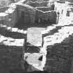
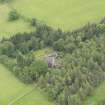
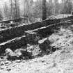
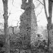
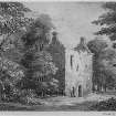
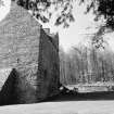
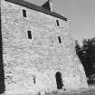
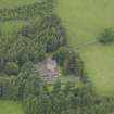
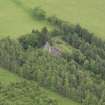
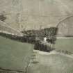
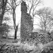
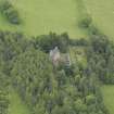
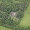
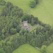
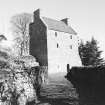
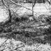
Whytebank Tower stands at 850ft OD on the E slope of Knowes Hill; it is one of the four towers in the district characterised by their association with terraced enclosures.
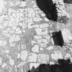
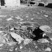
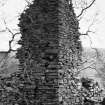
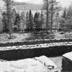
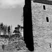
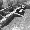
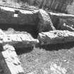
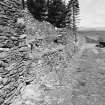
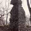
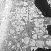
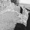
Built in the 16th century, it is now very dilapidated. Above the ground floor little survives except a 'tooth' of masonry at the W corner, which still stands 40ft high and bears the remains of a cap-house. Four storeys in height when entire, the building is oblong on plan, measuring 37 1/2 ft by 25ft, excluding a massive buttress which has been added to the SE end of the NE gable. The masonry is whin rubble.
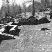
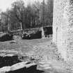
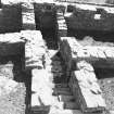
The courtyard, entered from the N and communicating with a level enclosure on the SE, measures 85ft by 60ft. The oblong building on its E side measures 90ft by 23ft.
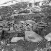
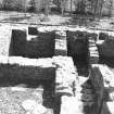
Now reduced to a ruinous ground floor, it contains four apartments, one vaulted. The ruinous oblong building at the SW corner of the courtyard was single-storeyed. It measures 38ft by 21 1/2 ft and appears to have been partly rebuilt. Another structure, which has almost entirely disappeared, lay between this and the building on the E side of the courtyard.
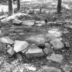
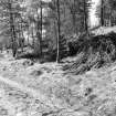
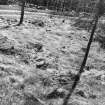
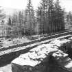
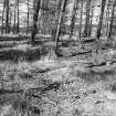
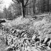
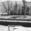
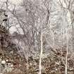
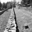
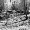
The tower is approached from the S by an old road which runs along a terrace parallel to the contour and flanked on the E by a second, lower terrace.
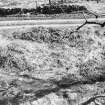
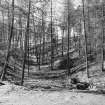
The upper terrace and the hillside above it are both revetted with drystone walling and the lower terrace may have been similarly revetted, although where the bank on the lower side is breached the construction seems to be heaped earth rather than building. These terraces extend for at least 300 yds until, on the N, they meet the enclosures surrounding the tower. Here the rocky hillside on the W of the approach has been extensively quarried and against the rock faces may be seen the remains of crudely built huts, all much later then the tower. The terrace carrying the road dies out on the W side of the tower.
The lower terrace broadens as it nears the site to accommodate the tower and its outbuildings.
On the E of the courtyard there are four more terraces, alternately broad and narrow, all of which show ruinous retaining walls of stone laid in clay in the revetment of one terrace there are two small recesses, probably for beehives. On the S of the courtyard there is a level enclosure situated at the N end of the lower terrace mentioned above; on its E side a long, narrow, sloping enclosure, probably an orchard, abuts on the S end of the four terraces E of the courtyard. RCAHMS 1957, visited 1934
One unroofed building annotated Whytbank (Ruins of) and a series of conjoined enclosures are depicted on the 1st edition of the OS 6-inch map (Selkirkshire 1863, sheet iii). Three unroofed buildings and a series of enclosures are shown on the current edition of the OS 1:10000 map (1982).
Information from RCAHMS (SAH) 12 September 2000
EXTERNAL REFERENCES
RCAHMS confirmed. Unable to confirm correct spelling of 'Whytbank'. Earthworks surveyed at 1:2500.
Visited by OS (WDJ) 6 January 1966
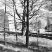
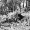
The owner of the properties concerned prefers the name without the 'e' in accordance with local spelling, and would preserve conformity as on title deeds and all estate correspondence. (Information from JM 1967) The remains of Whytbank Tower with its associated buildings and terraces are covered by dense vegetation but they are generally as described by the RCAHM.
Published survey (25") correct.
Visited by OS (MJF) 29 November 1979.
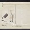
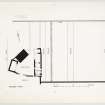
A detailed survey was carried out by Scotia Archaeology Limited of the tower, its courtyard and associated buildings; a terraced garden; and several outlying structures, perhaps associated with the occupation of the tower during the 18th and 19th centuries. The area surveyed measured approximately 170m by 170m.
Sponsor: The Mitchell Trust.
Lewis and Terry 1994
Sbc Note
Visibility: Upstanding building, which may not be intact.
Information from Scottish Borders Council

