 |
On-line Digital Images |
SC 505230 |
|
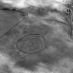
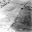
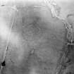
Huntly Burn, oblique aerial view, taken from the SW, centred on the cropmarks of two settlements, and an area of rig and furrow cultivation. |
|
Item Level |
|
 |
On-line Digital Images |
SC 1738396 |
RCAHMS Aerial Photography |
Oblique aerial view. |
1994 |
Item Level |
|
 |
On-line Digital Images |
SC 1738397 |
RCAHMS Aerial Photography |
Oblique aerial view. |
1994 |
Item Level |
|
 |
On-line Digital Images |
SC 1738398 |
RCAHMS Aerial Photography |
Oblique aerial view. |
1994 |
Item Level |
|
 |
On-line Digital Images |
SC 1738399 |
RCAHMS Aerial Photography |
Oblique aerial view. |
1994 |
Item Level |
|
 |
On-line Digital Images |
SC 1738400 |
RCAHMS Aerial Photography |
Oblique aerial view. |
1994 |
Item Level |
|
 |
On-line Digital Images |
SC 1738422 |
RCAHMS Aerial Photography |
Oblique aerial view. |
1992 |
Item Level |
|
 |
On-line Digital Images |
SC 1738423 |
RCAHMS Aerial Photography |
Oblique aerial view. |
1992 |
Item Level |
|
 |
On-line Digital Images |
SC 1738437 |
RCAHMS Aerial Photography |
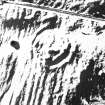
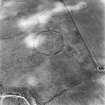
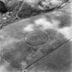
Huntly Burn, oblique aerial view, taken from the E, centred on the cropmarks of two settlements, and an area of rig and furrow cultivation. |
8/8/1995 |
Item Level |
|
 |
On-line Digital Images |
SC 1738438 |
RCAHMS Aerial Photography |
Huntly Burn, oblique aerial view, taken from the N, centred on the cropmarks of two settlements, and an area of rig and furrow cultivation. |
8/8/1995 |
Item Level |
|
 |
On-line Digital Images |
SC 1738439 |
RCAHMS Aerial Photography |
Huntly Burn, oblique aerial view, taken from the WNW, centred on the cropmarks of two settlements, and an area of rig and furrow cultivation. |
8/8/1995 |
Item Level |
|
 |
On-line Digital Images |
SC 1738440 |
RCAHMS Aerial Photography |
Huntly Burn, oblique aerial view, taken from the SW, centred on the cropmarks of two settlements, and an area of rig and furrow cultivation. |
8/8/1995 |
Item Level |
|
 |
On-line Digital Images |
SC 1738446 |
|
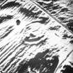
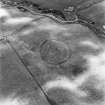
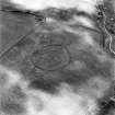
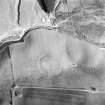
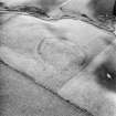
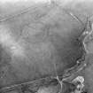
Huntly Burn, oblique aerial view, taken from the SW, centred on the cropmarks of a settlement and rig. A second enclosure is visible in the left centre of the photograph. |
26/7/1996 |
Item Level |
|
 |
On-line Digital Images |
SC 1738448 |
RCAHMS Aerial Photography |
Huntly Burn, oblique aerial view, taken from the SE, centred on the cropmarks of a settlement and rig. A second enclosure is partly visible in the upper left of the photograph. |
26/7/1996 |
Item Level |
|
 |
On-line Digital Images |
SC 1738449 |
RCAHMS Aerial Photography |
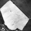
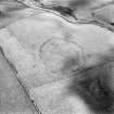
Huntly Burn, oblique aerial view, taken from the SE, centred on the cropmarks of a possible settlement. The cropmarks of a second settlement and rig are visible in the bottom right of the photograph. |
26/7/1996 |
Item Level |
|
 |
On-line Digital Images |
SC 1738450 |
RCAHMS Aerial Photography |
Huntly Burn, oblique aerial view, centred on the cropmarks of a settlement and rig. A seconf enclosure is visible in the upper middle of the photograph. |
26/7/1996 |
Item Level |
|
 |
On-line Digital Images |
SC 1738452 |
RCAHMS Aerial Photography |
Huntly Burn, oblique aerial view, taken from the NE, centred on the cropmarks of a possible settlement. The cropmarks of a second settlement and rig are visible in the left centre of the photograph. |
26/7/1996 |
Item Level |
|
 |
On-line Digital Images |
SC 1738472 |
RCAHMS Aerial Photography |
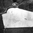
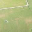
Oblique aerial view centred on the remains of the settlement, taken from the NW. |
11/5/2005 |
Item Level |
|
 |
On-line Digital Images |
SC 1738483 |
RCAHMS Aerial Photography |
Oblique aerial view. |
1981 |
Item Level |
|
 |
On-line Digital Images |
SC 1738484 |
RCAHMS Aerial Photography |
Oblique aerial view. |
1981 |
Item Level |
|
 |
On-line Digital Images |
SC 1738497 |
RCAHMS Aerial Photography |
Oblique aerial view |
1976 |
Item Level |
|
 |
On-line Digital Images |
SC 1738498 |
RCAHMS Aerial Photography |
Oblique aerial view |
1976 |
Item Level |
|
 |
On-line Digital Images |
DP 280776 |
Historic Environment Scotland |
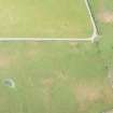
Oblique aerial view. |
14/7/2018 |
Item Level |
|
 |
On-line Digital Images |
DP 280777 |
Historic Environment Scotland |
Oblique aerial view. |
14/7/2018 |
Item Level |
|


