
Lettie's Grave


Square Cairn(S) (Iron Age)
Site Name Lettie's Grave
Classification Square Cairn(S) (Iron Age)
Canmore ID 5412
Site Number NC60NE 1
NGR NC 6920 0529
Datum OSGB36 - NGR
Permalink http://canmore.org.uk/site/5412


- Council Highland
- Parish Rogart
- Former Region Highland
- Former District Sutherland
- Former County Sutherland
NC60NE 1 6920 0529.
(NC 6920 0529) Lettie's Grave (NAT)
OS 6"map, (1969)
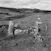
'Lettie's Grave' is a rectangular construction set on the flat haunch of the hill about 150ft above the Lettie River. It has apparently been about 7ft square internally with sides lying N-S and E-W. Only the E side seems to be complete; it consists of an upright stone at each end with two flat stones set on edge between them. Along the N side lie two stones, one small and just visible, and the other 4ft 5ins long. Three large boulders, which probably formed part of the structure, lie towards what would have been the SW corner.
About 40ft to the NW there is another rectangular structure about 5ft by 6ft internally, formed of boulders set on edge but with no standing stones at the corners.
A semblance of a third structure similar to the latter lies about 30ft to the west of 'Lettie's Grave'. Remains of crofter settlement occur in the immediate vicinity (NC60NE 2).
RCAHMS 1911, visited 1909.
Lettie's Grave, the position of which was indicated by Mr Bierman (Information from L Bierman, Blarich to OS), who says it is the grave of a local chief, is generally as described by the RCAHMS. The larger of the upright stones is 1.0m high. The other two structures mentioned by the RCAHMS are probably associated with the nearby depopulated settlement.
Visited by OS (W D J) 7 July 1963.
The area is named 'Lettie' by Morrison (1853) and was originally so named in the ONB (1872), but the spelling was changed to 'Leudaichte' by Rev Jas Joass. By 1908 it had become 'Leataidh' (OS 6"map, Sutherlandshire, 2nd ed., {1908}) which was probably pronouced the same as Morrison's form. It is presumably from this that the name 'Lettie's Grave' is derived.
H Morrison 1853; Name Book 1872.
No change to the previous field report.
Visited by OS (J M) 8 October 1980.
Field Visit (21 June 1995)
The remains of three square cairns stand on a bracken-covered terrace above the modern track which runs up the NE side of the Abhainn Leataidh. The cairns lie about 11m to 12 metres apart from one another in a roughly equilateral triangle.
The best-preserved cairn is that to the SE (ROG95 728), which measures 2.4m E-W by 2.2m transversely over a kerb of edge-set slabs up to 0.45m high which remain in situ only on the N and E. Corner posts at the NE and SE stand 0.9m and 1.1m high respectively, and large stones, which presumably stood at the other two corners, lie close to their probable original positions. Within the kerb the cairn material measures about 0.2m in height.
The second cairn (ROG95 729), to the NW, measures 2.7m square over a kerb which stands 0.45m high on the NE side but has largely been destroyed on the other sides; the cairn material within the kerb stands about 0.3m high. A large stone at the E corner stands 0.7m high, although as it is longer than it is high, it cannot be described as a corner post.
To the W of the first cairn there are traces of a third example (ROG95 730). This appears to have measured at least 1.7m square, although its NE and SE sides are poorly defined. There are the remains of a kerb at the W corner, one stone standing 0.3m high, otherwise the cairn barely rises above ground level. Two stones lying to the SE may be displaced kerb stones.
(ROG95 728-30)
Visited by RCAHMS (SDB) 21 June 1995
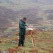
Measured Survey (18 May 1995)
RCAHMS surveyed three square cairns at Lettie’s Grave with alidade and plane-table on 18 May 1995 at a scale of 1:100. A cross-section through the best-preserved cairn was also recorded at 1:50. The resultant plan was redrawn in ink at a scale of 1:200.

