 |
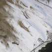
On-line Digital Images |
DP 086147 |
RCAHMS Aerial Photography Digital |
Oblique aerial view of the settlement, looking NW. |
2/3/2010 |
Item Level |
|
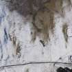 |
On-line Digital Images |
DP 086148 |
RCAHMS Aerial Photography Digital |
Oblique aerial view of the settlement and enclosures, looking W. |
2/3/2010 |
Item Level |
|
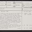 |
On-line Digital Images |
SC 2446638 |
Records of the Ordnance Survey, Southampton, Hampshire, England |
Broadhaugh Hill, NT40NE 10, Ordnance Survey index card, page number 1, Recto |
1958 |
Item Level |
|
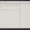 |
On-line Digital Images |
SC 2446639 |
Records of the Ordnance Survey, Southampton, Hampshire, England |
Broadhaugh Hill, NT40NE 10, Ordnance Survey index card, page number 2, Verso |
1958 |
Item Level |
|
 |
On-line Digital Images |
SC 2446640 |
Records of the Ordnance Survey, Southampton, Hampshire, England |
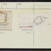
Broadhaugh Hill, NT40NE 10, Ordnance Survey index card, Recto |
1958 |
Item Level |
|
 |
On-line Digital Images |
SC 2446641 |
Records of the Ordnance Survey, Southampton, Hampshire, England |
Broadhaugh Hill, NT40NE 10, Ordnance Survey index card, Recto |
1958 |
Item Level |
|


