 |
On-line Digital Images |
SC 398070 |
|
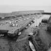
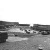
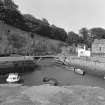
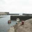
Dysart Harbour.
Slipway (left) and gated channel to inner basin. |
|
Item Level |
|
 |
On-line Digital Images |
SC 398071 |
|
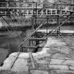
Dysart Harbour.
Detail of East gate. |
|
Item Level |
|
 |
On-line Digital Images |
SC 398072 |
|
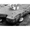
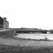
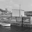
Dysart Harbour.
Recess for dock gates. |
|
Item Level |
|
 |
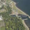
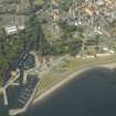
On-line Digital Images |
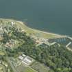
SC 398077 |
|
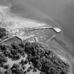
Dysart Harbour.
Aerial view from West. |
|
Item Level |
|
 |
On-line Digital Images |
SC 444498 |
Papers of Professor John R Hume, economic and industrial historian, Glasgow, Scotland |
Dysart, Harbou
View of Outer Basin from Ashlar Head, looking SE |
1974 |
Item Level |
|
 |
On-line Digital Images |
SC 444499 |
Papers of Professor John R Hume, economic and industrial historian, Glasgow, Scotland |
Dysart, Harbour
View of Inner Basin, looking S to Outer Basin |
1974 |
Item Level |
|
 |
On-line Digital Images |
SC 454946 |
Papers of Professor John R Hume, economic and industrial historian, Glasgow, Scotland |
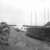
Dysart Harbour
View down slipway from carpark, from N |
2/9/1975 |
Item Level |
|
 |
On-line Digital Images |
SC 454947 |
Papers of Professor John R Hume, economic and industrial historian, Glasgow, Scotland |
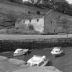
Dysart Harbour
View of inner basin and harbour buildings, from W |
2/9/1975 |
Item Level |
|
 |
On-line Digital Images |
SC 454948 |
Papers of Professor John R Hume, economic and industrial historian, Glasgow, Scotland |
Dysart Harbour
View of inner basin and harbour buildings, from S |
2/9/1975 |
Item Level |
|
 |
On-line Digital Images |
SC 454950 |
Papers of Professor John R Hume, economic and industrial historian, Glasgow, Scotland |
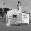
Dysart Harbour
View of building on tip of central pier, fom W |
2/9/1975 |
Item Level |
|
 |
On-line Digital Images |
SC 454951 |
Papers of Professor John R Hume, economic and industrial historian, Glasgow, Scotland |
Dysart Harbour
View of ruined storehouse on W quay, from S |
2/9/1975 |
Item Level |
|
 |
On-line Digital Images |
SC 454952 |
Papers of Professor John R Hume, economic and industrial historian, Glasgow, Scotland |
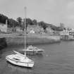
Dysart Harbour
View of outer basin, from S |
2/9/1975 |
Item Level |
|
 |
On-line Digital Images |
SC 454953 |
Papers of Professor John R Hume, economic and industrial historian, Glasgow, Scotland |
Dysart Harbour
View of building on central pier, from W |
2/9/1975 |
Item Level |
|
 |
On-line Digital Images |
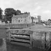
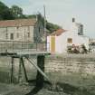
SC 791020 |
Papers of Professor John R Hume, economic and industrial historian, Glasgow, Scotland |
View from SW showing harbour footbridge with Harbourmaster's House in the background. |
1979 |
Item Level |
|
 |
On-line Digital Images |
SC 796164 |
Papers of Professor John R Hume, economic and industrial historian, Glasgow, Scotland |
General view from NNW |
1975 |
Item Level |
|
 |
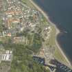
On-line Digital Images |
DP 016708 |
RCAHMS Aerial Photography Digital |
General oblique aerial view centred on the harbour with the monastery, garden, church, churchyard and burial ground adjacent, taken from the W. |
8/6/2006 |
Item Level |
|
 |
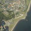
On-line Digital Images |
DP 016710 |
RCAHMS Aerial Photography Digital |
Oblique aerial view centred on the harbour with the monastery, garden, church, churchyard and burial ground adjacent, taken from the W. |
8/6/2006 |
Item Level |
|
 |
On-line Digital Images |
DP 016711 |
RCAHMS Aerial Photography Digital |
Oblique aerial view centred on the house, monastery and gardens with the church, burial ground and harbour adjacent, taken from the WSW. |
8/6/2006 |
Item Level |
|
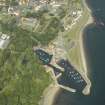 |
On-line Digital Images |
DP 016712 |
RCAHMS Aerial Photography Digital |
Oblique aerial view centred on the harbour with the monastery, garden, church, churchyard and burial ground adjacent, taken from the SW. |
8/6/2006 |
Item Level |
|
 |
On-line Digital Images |
DP 016714 |
RCAHMS Aerial Photography Digital |
Oblique aerial view centred on the house, monastery and gardens with the church, burial ground and harbour adjacent, taken from the SSW. |
8/6/2006 |
Item Level |
|
 |
On-line Digital Images |
DP 016715 |
RCAHMS Aerial Photography Digital |
Oblique aerial view centred on the harbour with the monastery, garden, church, churchyard and burial ground adjacent, taken from the SSE. |
8/6/2006 |
Item Level |
|
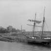 |
On-line Digital Images |
SC 1106694 |
Brian C Clayton |
View from South of harbour, St Serf's kirk and The Shore. Includes a top-sail schooner, called the 'Regina Brake'. |
c. 1930 |
Item Level |
|
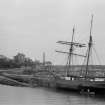 |
On-line Digital Images |
SC 1106695 |
Brian C Clayton |
View from South of harbour, St Serf's kirk and The Shore. Includes a top-sail schooner, called the 'Regina Brake'. |
c. 1930 |
Item Level |
|
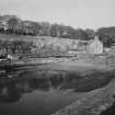 |
On-line Digital Images |
SC 1575435 |
Records of the Scottish National Buildings Record, Edinburgh, Scotland
|
View of Dysart harbour from S. |
11/1964 |
Item Level |
|


