
Methil Docks


Dock(S) (19th Century), Harbour (19th Century)
Site Name Methil Docks
Classification Dock(S) (19th Century), Harbour (19th Century)
Alternative Name(s) Methil Harbour; Firth Of Forth
Canmore ID 53943
Site Number NT39NE 11
NGR NT 37711 99545
NGR Description Centred NT 37711 99545
Datum OSGB36 - NGR
Permalink http://canmore.org.uk/site/53943


- Council Fife
- Parish Wemyss
- Former Region Fife
- Former District Kirkcaldy
- Former County Fife
NT39NE 11.00 centred 37711 99545
Location formerly entered as NT 375 995.
NT39NE 11.01 NT 37522 98977 Beacon ('Lighthouse' on breakwater)
NT39NE 11.02 NT 37520 98972 to NT c. 37739 99467 Breakwater
NT39NE 11.03 NT c. 37501 99134 to NT c. 37507 99281 Nos. 1 and 2 Docks, Entrance Channel
NT39NE 11.04 NT c. 37512 99079 to NT c. 37782 99602 No. 3 Dock, Entrance Channel
NT39NE 11.05 NT 37661 99443 Wave Basin
NT39NE 11.06 NT 37423 99230 Harbour
NT39NE 11.07 NT 37609 99630 No. 1 Dock
NT39NE 11.08 NT 37520 99412 No. 2 Dock
NT39NE 11.09 NT 33873 99751 No. 3 Dock
NT39NE 11.10 NT 37508 99295 Nos. 1 and 2 Docks, Entrance Gates
NT39NE 11.11 NT 37801 99633 No. 3 Dock, Entrance Lock
(Location cited as NT 37 99). Methil, Fife: no remains of the old harbour of Methil appear to have survived the construction of the modern docks, but the place deserves to be mentioned for various reasons. The fact that it was built about 1650 points to activity at that time in the local coal-mining industry, and as its builder was the 2nd Earl of Wemyss one is tempted to regard the harbour at West Wemyss (NT39SW 5), the date of which is unknown, as a parallel and contemporary development. This seems the more likely as the plans of the two harbours, as marked on Roy's Map of Scotland (1747-55), are distinctly similar, both consisting of a pair of piers which curve out from the shoreline to enclose a harbour-area segmental in shape. Adair, rather earlier, had noted 'two strong, high and well-built moles of hewen stone'.
A point of incidental interest is the colliery waggon-way, two miles [3.2km] long, that served the harbour at the end of the 18th century.
A Graham 1971.
There was probably a harbour at Methil by the 17th century and in 1795 a tramroad was built to it for the carriage of coal. The modern dock system results from improvements carried out in 1872-87 by the Wemyss family and in 1907-13 by the North British Rly.
B Lenman 1975.
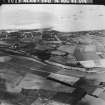
(Location cited as NT 995 375). Methil Harbour: in its present form dates from 1887 when a small wet dock was built for R Erskine Wemyss. It was extended between 1895 and 1913 by the North British Railway. It has 2 decayed piers at the north-east end to increase the number of berths available. There are 3 coal hoists still in position, with associated elevated railway lines. The earlier docks are built of stone, the latter of concrete. Both were designed for coal shipment, which finally ceased in 1970.
J R Hume 1976.
The Forth Ports Authority (FPA) was formed in 1968 to control the ports of Leith (NT27NE 57), Grangemouth (NS98SW 7), Burntisland (NT28NW 30), Methil (NT39NE 11), Kirkcaldy (NT29SE 44) and Granton (NT27NW 28), from headquarters at Leith. Between 1968 and 1983 over £40 million was spent on facilities. In 1982 over 27.5 million tonnes of cargo (of varied types) passed through the Firth of Forth. The FPA also controls the Forth Navigation Service, and is the pilotage authority. The FPA fleet provides towage at Leith, Granton and the Forth ports.
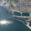
Situated close to the estuarine mouth of the Firth of Forth, the impounded Methil docks are chiefly important for the import of grain and other feedstuffs, timber, fertiliser and pulp; regular exports currently include scrap metal. Traffic has increased considerably in recent years, following the end of the port's traditional coal exports and a consequent major reconstruction of facilities. This has included the improvement of the road access, the resurfacing of quays, and the provision of new dock gates, transit sheds, and cranes. Storage provision for pulp has been increased in recent years, and further warehousing is planned. The creation of an industrial estate should occasion additional traffic at Methil, which already handles raw materials for a nearby fabrication yard. Principal details are as follows:
Access: half-tidal entrance 15.2m wide to Nos. 1 and 2 Docks. The maximum permissible beam is 14.4m, and the gates are normally opened between 3hrs before HW and HW.
Area: total water 16.4ha, total land 16.6ha.
No. 1 Dock: water area 1.9 ha, quayage 340m. (No transit sheds).
No. 2 Dock: water area 2.6 ha, quayage 500m, floor area of transit sheds 1120 sq. m. (There is road and rail access to both docks).
Total cargo handled in 1982 was 162,916t (128,971t inwards, and 33,945t outwards).
[Forth Ports Authority] 1983.
Site recorded by Maritime Fife during the Coastal Assessment Survey for Historic Scotland, Kincardine to Fife Ness 1996
Project (2007)
This project was undertaken to input site information listed in 'Civil engineering heritage: Scotland - Lowlands and Borders' by R Paxton and J Shipway, 2007.
Publication Account (2007)
Although a small coal shipping dock had existed from 1860 near the mouth of the Leven it was not until 1883–87 that the first thoroughly equipped dock was built (No. 1) to meet greatly increased coal production. It occupies 434 acres, has a 50 ft wide entrance with 24 ft of water on the sill and had three hydraulic hoists each capable of shipping 10 000 tons of coal per week. Soon afterwards it was sold to the North British Railway Company who, from 1894–99, built an additional wet dock of 6.5 acres (No. 2) with 27 ft
depth of water and similar capability, costing £300 000.
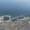
The third and outer dock was constructed in 1907–12, with area of 1634acres and a quay length of 6000 ft, at a
cost of about £700 000. Its entrance was 1800 ft long by 80 ft wide with a water depth of 32 ft. The scheme required construction, often in formidable weather, of a curved seawall in mass concrete some 3600 ft long and in places 41 ft high from rock foundation to quay level. It was partially protected from wave forces by some 700 concrete blocks, each weighing 50 tons, placed on its exposed outer base by a floating Titan crane.The contractor for this dock was Robert McAlpine&Sons and the consulting engineers were Blyth & Westland of
Edinburgh.
The scheme also required a power station, coal hoists, timber jetties, a railway bridge and some 14 miles of railway sidings. On its completion Methil was Scotland’s largest coal port. With the demise of the coal industry the outer dock area and sidings have been infilled and redeveloped but the original docks are still operational for present day requirements.
R Paxton and J Shipway 2007
Reproduced from 'Civil Engineering heritage: Scotland - Lowlands and Borders' with kind permission from Thomas Telford Publishers.

