
Inveresk


Temporary Camp (Roman)
Site Name Inveresk
Classification Temporary Camp (Roman)
Alternative Name(s) Monktonhall Junction
Canmore ID 53866
Site Number NT37SW 33
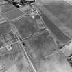
NGR NT 34800 71200
NGR Description Centred on NT 34800 71200
Datum OSGB36 - NGR
Permalink http://canmore.org.uk/site/53866


- Council East Lothian
- Parish Inveresk (East Lothian)
- Former Region Lothian
- Former District East Lothian
- Former County Midlothian
NT37SW 33 centred on NT 34800 71200
See also NT37SW 68 and NT37SW 77 -8, 182-6 and 1000-2, and NT37SE 49 and NT37SE 75.
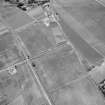
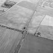
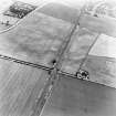
The most prominent of the linear cropmarks previously reported (St Joseph 1965) has been excavated and found to be a large V-shaped ditch, 6' deep, and characteristically Roman type. Cropmarks establish two sectors of its course, 975ft and 625ft in length, inclined at an obtuse angle, probably defining the NW and W sides of a larege camp, lying on carefully chosen ground protected on these sides by a scarp sloping down to the River Esk, and to the E by the extensive Howe Mire, now converted to arable land. Repeated search has failed to reveal a corresponding ditch to E and SE. However the E-W dimension is unlikely to be less than 1550ft, and there is space for a camp of the largest size. The position is six miles from Pathhead, and it may be noted that this is the last space S of the fort in Inveresk village on which it is possible to lay out, on level ground, a camp of 120 acres or more.
J K St Joseph 1969
An area of featureless pasture land containing no surface indications of these markings.
OS Field Report April 1975
Parts of the W and S sides of the ditch of a large Roman temporary ca mp of perhaps 50 acres (20ha) were uncovered. Sections showed a sharp V-shaped profile (2m to 3m wide; 1m deep), but provided no dating evidence.
W S Hanson 1985
The possibility that the large camp at Inveresk might be a member of the 65 ha (165 acre) group, also presumed to be of Severan date, has not been confirmed. Its S side, which appears as a linear cropmark running for 274m parallel to the SE side of the lane from the main road A6124, to Cowpits, was observed during reconnaissance in 1981 and earlier years. The feature is crossed by a branch railway and extends beneath an old school house and cottages. At one point there is a detached length of ditch like a traverse set forward to the SE, presumably marking an entrance; the main cropmark, though not interrupted, appreciably narrows opposite the traverse. Two exploratory trenches revealed, where the cropmark was of full-width, a V-shaped ditch 2.7m wide and 1.8m deep from the present surface; where the cropmark narrowed there was a smaller ditch 1.8m wide and only 1.2m deep.
G S Maxwell and D R Wilson 1987.
NT 3210 7303 to NT 3579 7184 Archaeological works along the line of a sewer pipeline revealed significant archaeological remains. The pipeline ran for 5km between Wallyford Waste Water Treatment Works and the eastern interceptor sewer near Portobello.
The investigation of an extensive area of cropmarks at Inveresk, specifically those to the S of the Edinburgh to Dunbar railway line, exposed three main groups of features: linear features that formed enclosures (NMRS NT37SE 50) and field systems lying on a pronounced gravel ridge; two Roman temporary marching camps (NMRS NT37SW 33 and NT37SW 186 ); and features whose function and origin is not known (NMRS NT37SW 68 and NT37SW 182 ).
The main group of cropmark features (NMRS NT37SE 50), is assumed to represent the southern extent of a field system associated with Inveresk Roman fort to the N and comprises four feature groups: a series of ditches bounding large areas to the NE; a series of smaller enclosures; a small rectilinear enclosure to the far SW; and a linear trackway running roughly NE-SW through the series of smaller enclosures
Sponsor: M J Gleeson Group plc.
Murray Cook 2001
Trial Trench (26 October 1966 - 30 October 1966)
The most prominent of the linear cropmarks previously reported (St Joseph 1965) has been excavated and found to be a large V-shaped ditch, 6' deep, and characteristically Roman type. Cropmarks establish two sectors of its course, 975ft and 625ft in length, inclined at an obtuse angle, probably defining the NW and W sides of a larege camp, lying on carefully chosen ground protected on these sides by a scarp sloping down to the River Esk, and to the E by the extensive Howe Mire, now converted to arable land. Repeated search has failed to reveal a corresponding ditch to E and SE. However the E-W dimension is unlikely to be less than 1550ft, and there is space for a camp of the largest size. The position is six miles from Pathhead, and it may be noted that this is the last space S of the fort in Inveresk village on which it is possible to lay out, on level ground, a camp of 120 acres or more.
J K St Joseph 1969
Field Visit (April 1975)
An area of featureless pasture land containing no surface indications of these markings.
OS Field Report April 1975
Excavation (30 June 1984 - 31 July 1984)
Trial Trench (1985)
Parts of the W and S sides of the ditch of a large Roman temporary ca mp of perhaps 50 acres (20ha) were uncovered. Sections showed a sharp V-shaped profile (2m to 3m wide; 1m deep), but provided no dating evidence.
W S Hanson 1985
Trial Trench (1987)
The possibility that the large camp at Inveresk might be a member of the 65 ha (165 acre) group, also presumed to be of Severan date, has not been confirmed. Its S side, which appears as a linear cropmark running for 274m parallel to the SE side of the lane from the main road A6124, to Cowpits, was observed during reconnaissance in 1981 and earlier years. The feature is crossed by a branch railway and extends beneath an old school house and cottages. At one point there is a detached length of ditch like a traverse set forward to the SE, presumably marking an entrance; the main cropmark, though not interrupted, appreciably narrows opposite the traverse. Two exploratory trenches revealed, where the cropmark was of full-width, a V-shaped ditch 2.7m wide and 1.8m deep from the present surface; where the cropmark narrowed there was a smaller ditch 1.8m wide and only 1.2m deep.
G S Maxwell and D R Wilson 1987.
Archaeological Evaluation (2001)
NT 3210 7303 to NT 3579 7184 Archaeological works along the line of a sewer pipeline revealed significant archaeological remains. The pipeline ran for 5km between Wallyford Waste Water Treatment Works and the eastern interceptor sewer near Portobello.
The investigation of an extensive area of cropmarks at Inveresk, specifically those to the S of the Edinburgh to Dunbar railway line, exposed three main groups of features: linear features that formed enclosures (NMRS NT 37 SE 50) and field systems lying on a pronounced gravel ridge; two Roman temporary marching camps (NMRS NT 37 SW 33 and 186); and features whose function and origin is not known (NMRS NT 37 SW 68 and 182).
The main group of cropmark features (NMRS NT 37 SE 50), is assumed to represent the southern extent of a field system associated with Inveresk Roman fort to the N and comprises four feature groups: a series of ditches bounding large areas to the NE; a series of smaller enclosures; a small rectilinear enclosure to the far SW; and a linear trackway running roughly NE-SW through the series of smaller enclosures
Sponsor: M J Gleeson Group plc.
Murray Cook 2001
Publication Account (17 December 2011)
The camps at Inveresk lie on the east side of the River Esk at Musselburgh, south-east of the Antonine fort which sits on a high plateau in a meander of the river. A vicus sits to the east of the fort and other features in the area include a field system, a triple-ditched feature and an unusual structure interpreted as a possible amphitheatre (Neighbour 2002a), as well as monuments of other periods (a probable Neolithic cursus monument and a possible long cist cemetery).
Both camps were recorded as cropmarks by St Joseph in the 1960s (1965: 80; 1969: 107–8). Camp II, the smaller of the two, sits within camp I and probably utilised part of its perimeter. Parts of three sides of camp I are known, demonstrating that it enclosed around 460m from north-west to south-east by at least 350m trans- versely; the location of the north east side is unknown. It therefore enclosed at least 16.3ha (40 acres) and possibly close to 22ha (54 acres). Entrance gaps protected by tituli are visible in the south-west and south-east sides.
Various excavations have taken place on the camps and other features in the vicinity. In 1966, St Joseph excavated on the north-west side and recorded a large V-shaped ditch, 1.75m deep and 3m wide filled with silt and large stones (RCAHMS St Joseph Collection: Notebook 4). Further excavations in 1981 recorded slightly smaller dimensions, along with a small V-shaped ditch across the causeway of the gate on the south-east side, possibly indicating a secondary use (see Inveresk II (Rankov 1982: 340; RCAHMS St Joseph Collection: Notebook 8)). Hanson excavated on the south-west and south-east sides in the mid-1980s in advance of road construction, recording that the ditch was V-shaped, up to 1m deep and 2–3m wide; one section produced a fragment of Antonine samian. He suggested that the ditches may have been deliberately backfilled on the basis of the gravel in-fill (Hanson 2002: 53). Later excavations by Cook on the north-west side of Inveresk I recorded a section of that camp and two other ditches which he originally interpreted as possible camps (2002a: 66–8) but subsequently suggested that not all may relate to the Roman occupation (2005). Given that the field system produced V-shaped ditches with apparent ‘ankle-breaker’ slots, the interpretation of features in this area as being part of temporary camps must be treated with caution. In addition to sections of ditch, Hanson’s excavations also recorded five probable ‘dumb-bell-shaped’ ovens, up to 3m long and 1.5m wide, containing charcoal and carbonised grain (Hanson 2002: 53–5). Cook’s excavations revealed a further possible field oven (‘a bipartite pit filled with ash and charcoal’) close to the north-west side of the camp and cut by a later ditch. This produced radiocarbon dates of the late 1st and early 2nd century ad (Cook 2005: 153).
A series of pits is also visible on the air photographs close to the west part of the north-west side. It is possible that these pits represent further remains of ovens. Some 250m of the north-west side of camp II are known, with a central entrance gap and titulus, together with a rounded corner angle and short stretch of the adjacent north-east side. St Joseph excavated eight trenches to establish the line of the ditch and gate on this camp in 1967, and noted that it had a small V-shaped ditch, 0.75m deep and 1.7m wide (St Joseph 1969: 108). The gate was 10.4m wide with the titulus ditch set some 8m from the entrance (RCAHMS St Joseph Collection: Notebook 4). The ditch of the titulus was interrupted by the rectangular slot of a foundation trench for a timber building. The top of this revealed a worn dupondius, possibly of Domitian (St Joseph 1969: 108).
If camp II utilised the southern portion of camp I, suggested by St Joseph’s excavations on the south-east entrance of this camp, then it could be almost 300m in length and enclose around 8.5ha (21 acres). Hanson’s excavations did not show any sign of recutting of the ditch of camp I, which led him to suggest that there may have been a short time-gap between the occupation of the two camps (2002a: 57).
R H Jones.

