 |
On-line Digital Images |
SC 1681279 |
RCAHMS Aerial Photography |
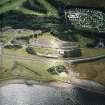
Oblique aerial view centred on the museum and the remains of the coal mine, brick and tileworks and harbour, taken from the NNW. |
13/7/2004 |
Item Level |
|
|
Photographs and Off-line Digital Images |
SC 2218617 |
Records of the Royal Commission on the Ancient and Historical Monuments of Scotland (RCAHMS), Edinbu |
Coalfields of Scotland: Distribution map of Collieries in the Fifeshire and Lothians coalfields.
Map of Collieries in 1942 |
1942 |
Item Level |
|
 |
On-line Digital Images |
SC 2446045 |
Records of the Ordnance Survey, Southampton, Hampshire, England |
Prestongrange Colliery, NT37SE 78, Ordnance Survey index card, Recto |
1958 |
Item Level |
|
 |
On-line Digital Images |
SC 2588483 |
|
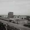
Prestongrange Colliery.
View of pithead baths. |
c. 1960 |
Item Level |
|
 |
On-line Digital Images |
SC 2588484 |
|
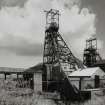
Prestongrange Colliery.
General view of surface arrangement. |
c. 1960 |
Item Level |
|


